Estimated Value: $297,956 - $332,000
4
Beds
3
Baths
2,532
Sq Ft
$122/Sq Ft
Est. Value
About This Home
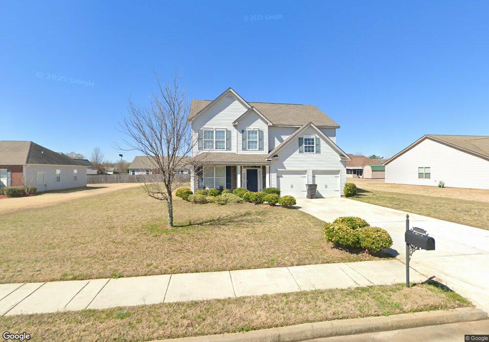
This home is located at 218 Cumberland Dr, Byron, GA 31008 and is currently estimated at $309,489, approximately $122 per square foot. 218 Cumberland Dr is a home located in Peach County with nearby schools including Byron Elementary School, Byron Middle School, and Peach County High School.
Ownership History
Date
Name
Owned For
Owner Type
Purchase Details
Closed on
Mar 29, 2010
Sold by
D R Horton Inc
Bought by
Lamb Jamessa R
Current Estimated Value
Home Financials for this Owner
Home Financials are based on the most recent Mortgage that was taken out on this home.
Original Mortgage
$157,091
Outstanding Balance
$104,289
Interest Rate
5.25%
Mortgage Type
FHA
Estimated Equity
$205,200
Purchase Details
Closed on
Jan 23, 2009
Sold by
Cumberland Shores Llc
Bought by
D R Horton Inc
Purchase Details
Closed on
Feb 22, 2005
Sold by
Vinson Jr Edgar Keith and Vinson Jr Robert Grayden
Bought by
Cumberland Shores Llc
Purchase Details
Closed on
Jan 3, 2003
Sold by
Vinson Edgar Keith and Robert Grayden
Bought by
Cumberland Shores Llc
Create a Home Valuation Report for This Property
The Home Valuation Report is an in-depth analysis detailing your home's value as well as a comparison with similar homes in the area
Home Values in the Area
Average Home Value in this Area
Purchase History
| Date | Buyer | Sale Price | Title Company |
|---|---|---|---|
| Lamb Jamessa R | $159,990 | -- | |
| D R Horton Inc | $61,950 | -- | |
| Cumberland Shores Llc | -- | -- | |
| Cumberland Shores Llc | -- | -- |
Source: Public Records
Mortgage History
| Date | Status | Borrower | Loan Amount |
|---|---|---|---|
| Open | Lamb Jamessa R | $157,091 |
Source: Public Records
Tax History
| Year | Tax Paid | Tax Assessment Tax Assessment Total Assessment is a certain percentage of the fair market value that is determined by local assessors to be the total taxable value of land and additions on the property. | Land | Improvement |
|---|---|---|---|---|
| 2025 | $4,374 | $125,400 | $13,960 | $111,440 |
| 2024 | $4,033 | $113,000 | $13,720 | $99,280 |
| 2023 | $3,974 | $110,640 | $11,000 | $99,640 |
| 2022 | $2,649 | $98,400 | $11,000 | $87,400 |
| 2021 | $2,505 | $80,240 | $8,800 | $71,440 |
| 2020 | $2,313 | $74,080 | $8,800 | $65,280 |
| 2019 | $2,324 | $74,080 | $8,800 | $65,280 |
| 2018 | $2,345 | $74,360 | $8,800 | $65,560 |
| 2017 | $2,356 | $74,360 | $8,800 | $65,560 |
| 2016 | $2,346 | $74,360 | $8,800 | $65,560 |
| 2015 | $2,350 | $74,360 | $8,800 | $65,560 |
| 2014 | $2,354 | $74,360 | $8,800 | $65,560 |
| 2013 | -- | $74,360 | $8,800 | $65,560 |
Source: Public Records
Map
Nearby Homes
- 206 Christopher Dr
- 246 Shantz Way Unit (LOT A40)
- 246 Shantz Way
- 106 Christopher Dr
- 250 Shantz Way
- 250 Shantz Way Unit LOT A42
- 252 Shantz Way Unit (LOT A43)
- 252 Shantz Way
- 262 Shantz Way Unit (LOT A48)
- 0 Peavy Rd
- 0 W White West Rd
- 174 Majestic Oak Cir
- 205 White Rd
- 109 Belfair Dr
- 118 Manchester Ln
- 424 Lamplight Dr Unit LOT D55
- 424 Lamplight Dr
- 108 Manchester Ln
- 420 Lamplight Dr
- 106 Gassett Ct
- 218 Cumberland Drive(2015)
- 216 Cumberland Dr
- 220 Cumberland Dr
- 121 Christopher Dr
- 123 Christopher Dr
- 119 Christopher Dr
- 214 Cumberland Dr
- 222 Cumberland Dr
- 222 Cumberland Dr Unit 3067
- 222 Cumberland Drive(34)
- 217 Cumberland Dr
- 219 Cumberland Dr
- 125 Christopher Dr
- 215 Cumberland Dr
- 215 Cumberland Drive (13)
- 221 Cumberland Dr
- 221 Cumberland Dr Unit 3002
- 221 Cumberland Drive(3002)
- 117 Christopher Dr
- 212 Cumberland Dr
Your Personal Tour Guide
Ask me questions while you tour the home.