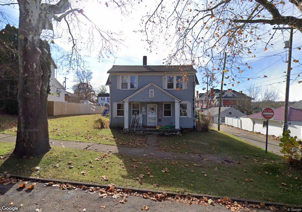
218 E A St Wellston, OH 45692
Estimated Value: $153,749 - $185,000
3
Beds
2
Baths
1,586
Sq Ft
$107/Sq Ft
Est. Value
About This Home
This home is located at 218 E A St, Wellston, OH 45692 and is currently estimated at $169,437, approximately $106 per square foot. 218 E A St is a home located in Jackson County with nearby schools including Bundy Elementary School, Wellston Intermediate School, and Wellston Middle School.
Ownership History
Date
Name
Owned For
Owner Type
Purchase Details
Closed on
Dec 10, 2007
Sold by
Kemp Robert H and Kemp Julia A
Bought by
Long Edward S and Long Kelli G
Current Estimated Value
Home Financials for this Owner
Home Financials are based on the most recent Mortgage that was taken out on this home.
Original Mortgage
$58,997
Interest Rate
5.2%
Mortgage Type
Future Advance Clause Open End Mortgage
Purchase Details
Closed on
Dec 7, 2007
Sold by
Kemp Robert H and Kemp Julie A
Bought by
Long Edward S and Long Kelli G
Home Financials for this Owner
Home Financials are based on the most recent Mortgage that was taken out on this home.
Original Mortgage
$58,997
Interest Rate
5.2%
Mortgage Type
Future Advance Clause Open End Mortgage
Purchase Details
Closed on
May 30, 2002
Sold by
Hagerty Michael L
Bought by
Kemp Robert H and Kemp Julie A
Create a Home Valuation Report for This Property
The Home Valuation Report is an in-depth analysis detailing your home's value as well as a comparison with similar homes in the area
Home Values in the Area
Average Home Value in this Area
Purchase History
| Date | Buyer | Sale Price | Title Company |
|---|---|---|---|
| Long Edward S | $10,750 | None Available | |
| Long Edward S | $69,000 | None Available | |
| Kemp Robert H | $58,000 | -- |
Source: Public Records
Mortgage History
| Date | Status | Borrower | Loan Amount |
|---|---|---|---|
| Open | Long Edward S | $6,304 | |
| Previous Owner | Long Edward S | $58,997 |
Source: Public Records
Tax History
| Year | Tax Paid | Tax Assessment Tax Assessment Total Assessment is a certain percentage of the fair market value that is determined by local assessors to be the total taxable value of land and additions on the property. | Land | Improvement |
|---|---|---|---|---|
| 2025 | $7,542 | $34,710 | $4,540 | $30,170 |
| 2024 | $5,737 | $34,710 | $4,540 | $30,170 |
| 2023 | $4,135 | $34,710 | $4,540 | $30,170 |
| 2022 | $1,133 | $23,960 | $3,890 | $20,070 |
| 2021 | $958 | $23,960 | $3,890 | $20,070 |
| 2020 | $981 | $23,960 | $3,890 | $20,070 |
| 2019 | $980 | $23,210 | $3,780 | $19,430 |
| 2018 | $952 | $23,210 | $3,780 | $19,430 |
| 2017 | $3,918 | $23,210 | $3,780 | $19,430 |
| 2016 | $1,819 | $22,580 | $4,200 | $18,380 |
| 2015 | $891 | $22,580 | $4,200 | $18,380 |
| 2013 | $817 | $21,680 | $4,200 | $17,480 |
| 2012 | $2,823 | $21,680 | $4,200 | $17,480 |
Source: Public Records
Map
Nearby Homes
- 22 N Pennsylvania Ave
- 16 N Pennsylvania Ave
- 223 E Broadway St
- 1 N New York Ave
- 217 E A St
- 219 E A St
- 304 E A St
- 215 E A St
- 221 E A St
- 104 N Pennsylvania Ave
- 114 N Pennsylvania Ave
- 312 E A St
- 4 N New York Ave
- 0 State Route 93 Unit 9912693
- 301 E A St
- 116 N Pennsylvania Ave
- 309 E A St
- 220 E B St
- 320 E A St
- 21 N Pennsylvania Ave
Your Personal Tour Guide
Ask me questions while you tour the home.