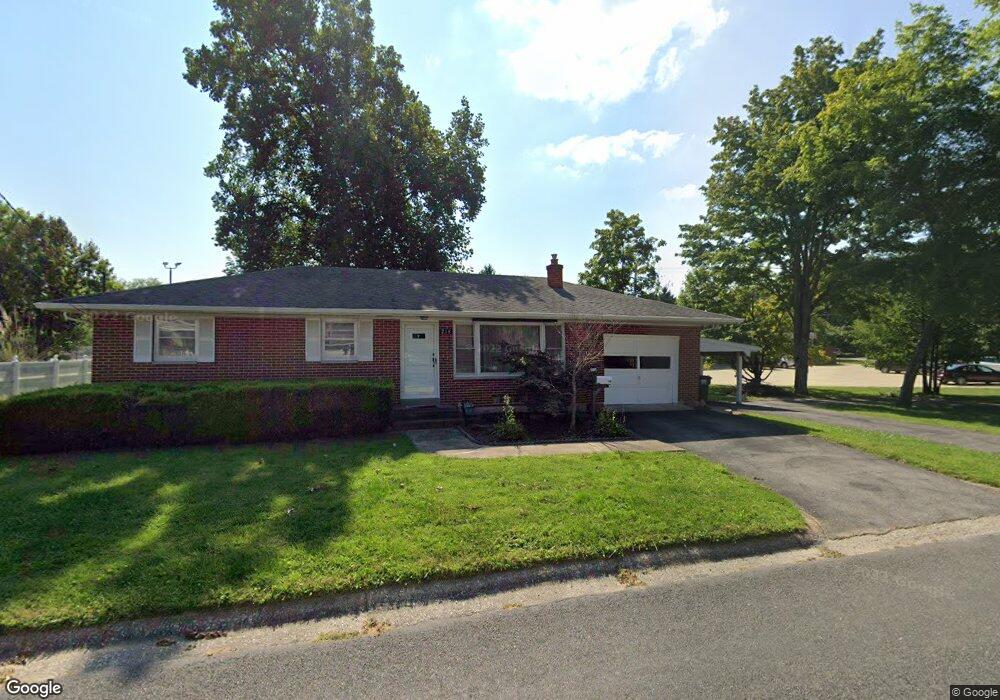
218 E Locust St Columbia, IL 62236
Estimated Value: $159,705 - $261,000
3
Beds
--
Bath
1,040
Sq Ft
$204/Sq Ft
Est. Value
About This Home
This home is located at 218 E Locust St, Columbia, IL 62236 and is currently estimated at $212,426, approximately $204 per square foot. 218 E Locust St is a home located in Monroe County with nearby schools including Columbia Middle School, Columbia High School, and Gibault Catholic High School.
Ownership History
Date
Name
Owned For
Owner Type
Purchase Details
Closed on
May 31, 2018
Sold by
Hutchings Donald R and Hutchings Sharron E
Bought by
Demond Kristin M
Current Estimated Value
Home Financials for this Owner
Home Financials are based on the most recent Mortgage that was taken out on this home.
Original Mortgage
$130,500
Outstanding Balance
$113,350
Interest Rate
4.88%
Mortgage Type
New Conventional
Estimated Equity
$99,076
Create a Home Valuation Report for This Property
The Home Valuation Report is an in-depth analysis detailing your home's value as well as a comparison with similar homes in the area
Home Values in the Area
Average Home Value in this Area
Purchase History
| Date | Buyer | Sale Price | Title Company |
|---|---|---|---|
| Demond Kristin M | $145,000 | Accent Title Inc |
Source: Public Records
Mortgage History
| Date | Status | Borrower | Loan Amount |
|---|---|---|---|
| Open | Demond Kristin M | $130,500 |
Source: Public Records
Tax History
| Year | Tax Paid | Tax Assessment Tax Assessment Total Assessment is a certain percentage of the fair market value that is determined by local assessors to be the total taxable value of land and additions on the property. | Land | Improvement |
|---|---|---|---|---|
| 2024 | $2,327 | $40,713 | $8,734 | $31,979 |
| 2023 | $2,358 | $38,550 | $8,270 | $30,280 |
| 2022 | $2,398 | $38,550 | $8,270 | $30,280 |
| 2021 | $2,378 | $38,550 | $8,270 | $30,280 |
| 2020 | $2,678 | $49,540 | $8,270 | $41,270 |
| 2019 | $2,857 | $46,830 | $8,270 | $38,560 |
| 2018 | $2,249 | $41,750 | $8,270 | $33,480 |
| 2017 | $2,213 | $42,512 | $8,419 | $34,093 |
| 2016 | $0 | $40,380 | $8,070 | $32,310 |
| 2015 | $2,216 | $41,820 | $8,380 | $33,440 |
| 2014 | $1,893 | $37,710 | $8,380 | $29,330 |
| 2012 | -- | $46,060 | $7,220 | $38,840 |
Source: Public Records
Map
Nearby Homes
- 203 S Metter Ave
- 214 E Market St
- 422 E Cherry St
- 103 N Rapp Ave
- 221 S Rapp Ave
- 209 Heritage St
- 000 Young Or Divers
- 9700 Route 3
- 3 Ogle Estates
- 1 Ogle Estates
- 419 Dianne Ave
- 527 Fairfax Dr
- 1504 Gedern Dr
- 1597 Ghent Rd
- 1374 Walnut Ridge Dr
- 0 Timber Rock Lot 39 Unit MIS25078033
- 0 Timber Rock Lot 40 Unit MIS25078031
- 0 Timber Rock Lot 38 Unit MIS25078035
- 0 Timber Rock Lot 32 Unit MIS25078226
- 0 Timber Rock Lot 37 Unit MIS25078038
- 226 E Locust St
- 205 N Briegel St
- 210 E Mulberry St
- 209 N Briegel St
- 0 N Briegel Unit 22055870
- 206 N Briegel St
- 210 N Metter Ave
- 210 N Briegel St
- 300 E Locust St
- 209 E Mulberry St
- 115 N Metter Ave
- 217 E Mulberry St
- 217 N Briegel St
- 218 N Metter Ave
- 216 N Briegel St
- 317 E Locust St
- 203 N Metter Ave
- 314 E Mulberry St
- 105 N Metter Ave
- 224 N Metter Ave