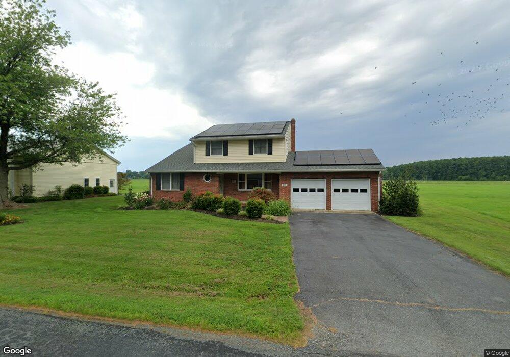
218 Kentmorr Rd Stevensville, MD 21666
Estimated Value: $569,000 - $614,000
--
Bed
2
Baths
1,994
Sq Ft
$299/Sq Ft
Est. Value
About This Home
This home is located at 218 Kentmorr Rd, Stevensville, MD 21666 and is currently estimated at $595,696, approximately $298 per square foot. 218 Kentmorr Rd is a home located in Queen Anne's County with nearby schools including Matapeake Elementary School, Matapeake Middle School, and Kent Island High School.
Ownership History
Date
Name
Owned For
Owner Type
Purchase Details
Closed on
Jul 11, 2007
Sold by
Martin Mary Virginia Trustee
Bought by
Howey Paul W
Current Estimated Value
Purchase Details
Closed on
Jun 29, 2007
Sold by
Martin Mary Virginia Trustee
Bought by
Howey Paul W
Purchase Details
Closed on
Apr 2, 2007
Sold by
Martin Robert C and Martin Mary
Bought by
Martin Mary Virginia Trustee
Purchase Details
Closed on
Mar 17, 2007
Sold by
Martin Robert C and Martin Mary
Bought by
Martin Mary Virginia Trustee
Create a Home Valuation Report for This Property
The Home Valuation Report is an in-depth analysis detailing your home's value as well as a comparison with similar homes in the area
Home Values in the Area
Average Home Value in this Area
Purchase History
| Date | Buyer | Sale Price | Title Company |
|---|---|---|---|
| Howey Paul W | $450,000 | -- | |
| Howey Paul W | $450,000 | -- | |
| Martin Mary Virginia Trustee | -- | -- | |
| Martin Mary Virginia Trustee | -- | -- |
Source: Public Records
Tax History Compared to Growth
Tax History
| Year | Tax Paid | Tax Assessment Tax Assessment Total Assessment is a certain percentage of the fair market value that is determined by local assessors to be the total taxable value of land and additions on the property. | Land | Improvement |
|---|---|---|---|---|
| 2025 | $4,243 | $513,233 | $0 | $0 |
| 2024 | $4,045 | $492,567 | $0 | $0 |
| 2023 | $3,915 | $471,900 | $264,000 | $207,900 |
| 2022 | $3,726 | $444,533 | $0 | $0 |
| 2021 | $3,430 | $417,167 | $0 | $0 |
| 2020 | $3,430 | $389,800 | $184,100 | $205,700 |
| 2019 | $3,256 | $359,567 | $0 | $0 |
| 2018 | $3,089 | $329,333 | $0 | $0 |
| 2017 | $2,929 | $299,100 | $0 | $0 |
| 2016 | -- | $299,100 | $0 | $0 |
| 2015 | $3,907 | $299,100 | $0 | $0 |
| 2014 | $3,907 | $367,500 | $0 | $0 |
Source: Public Records
Map
Nearby Homes
- 0 Reynolds Ave
- 114 Queens Colony High Rd
- 0 Allen Ave
- 511 Chesapeake Ave
- 303 Queens Colony High Rd
- 312 Queens Colony High Rd
- 206 Columbia Ln
- 410 5 Farms Dr
- 227 Queen Anne Club Dr
- 303 Queen Anne Club Dr
- 412 Five Farms Dr
- 312 Columbia Ln
- Lot 7 Maple Rd
- 103 Chesapeake Estates Dr
- 0 Chesapeake Estates Dr
- 116 Mallard Dr
- 122 Mallard Dr
- 1709 Batts Neck Rd
- 100 Eareckson Ln
- 101 Oak St
- 217 Kentmorr Rd
- 215 Kentmorr Rd
- 302 Kentmorr Rd
- 211 Kentmorr Rd
- 0 Kentmorr Rd
- 207 Kentmorr Rd
- 301 Kentmorr Rd
- 200 Kentmorr Rd
- 203 Kentmorr Rd
- 310 Kentmorr Rd
- 313 Kentmorr Rd
- 120 Kentmorr Rd
- 123 Kentmorr Rd
- 317 Kentmorr Rd
- 318 Kentmorr Rd
- 119 Kentmorr Rd
- 114 Kentmorr Rd
- 115 Kentmorr Rd
- 403 Kentmorr Rd
- 400 Kentmorr Rd