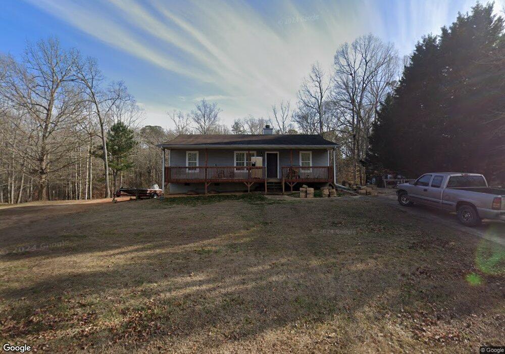
218 Rustin Dr Dallas, GA 30157
Estimated Value: $252,646 - $273,000
3
Beds
2
Baths
1,118
Sq Ft
$235/Sq Ft
Est. Value
About This Home
This home is located at 218 Rustin Dr, Dallas, GA 30157 and is currently estimated at $262,912, approximately $235 per square foot. 218 Rustin Dr is a home located in Paulding County with nearby schools including Union Elementary School, Carl Scoggins Sr. Middle School, and South Paulding High School.
Ownership History
Date
Name
Owned For
Owner Type
Purchase Details
Closed on
Mar 3, 2011
Sold by
Dennis Kimberlie J
Bought by
Nicholson Donald Trust
Current Estimated Value
Purchase Details
Closed on
Apr 27, 2001
Sold by
Ted Construction Co Inc
Home Financials for this Owner
Home Financials are based on the most recent Mortgage that was taken out on this home.
Original Mortgage
$86,235
Interest Rate
6.95%
Mortgage Type
FHA
Purchase Details
Closed on
Apr 19, 2001
Sold by
Ted Construction Co Inc
Bought by
Dennis Kimberlie J
Home Financials for this Owner
Home Financials are based on the most recent Mortgage that was taken out on this home.
Original Mortgage
$86,235
Interest Rate
6.95%
Mortgage Type
FHA
Create a Home Valuation Report for This Property
The Home Valuation Report is an in-depth analysis detailing your home's value as well as a comparison with similar homes in the area
Home Values in the Area
Average Home Value in this Area
Purchase History
| Date | Buyer | Sale Price | Title Company |
|---|---|---|---|
| Nicholson Donald Trust | $35,000 | -- | |
| Donald Nicholson Irrevocable Trust | $35,000 | -- | |
| -- | $87,000 | -- | |
| Dennis Kimberlie J | $87,000 | -- |
Source: Public Records
Mortgage History
| Date | Status | Borrower | Loan Amount |
|---|---|---|---|
| Previous Owner | Dennis Kimberlie J | $86,235 |
Source: Public Records
Tax History
| Year | Tax Paid | Tax Assessment Tax Assessment Total Assessment is a certain percentage of the fair market value that is determined by local assessors to be the total taxable value of land and additions on the property. | Land | Improvement |
|---|---|---|---|---|
| 2025 | $558 | $103,224 | $12,000 | $91,224 |
| 2024 | $1,212 | $96,204 | $12,000 | $84,204 |
| 2023 | $1,241 | $91,128 | $12,000 | $79,128 |
| 2022 | $1,177 | $80,436 | $12,000 | $68,436 |
| 2021 | $1,463 | $61,508 | $8,000 | $53,508 |
| 2020 | $1,310 | $55,204 | $8,000 | $47,204 |
| 2019 | $1,199 | $50,904 | $8,000 | $42,904 |
| 2018 | $1,298 | $43,076 | $8,000 | $35,076 |
| 2017 | $801 | $37,412 | $6,000 | $31,412 |
Source: Public Records
Map
Nearby Homes
- 177 Rustin Dr
- 0 Rustin Dr Unit 10617842
- 0 Rustin Dr Unit 7657021
- 128 Tanner Dr
- 8713 Buchanan Hwy
- 453 Mulberry Rock Rd
- 391 Mulberry Rock Rd
- 42 Bryan Miller Rd
- 8277 Buchanan Hwy
- 292 Harmony Woods Dr
- 723 Mulberry Rock Rd
- 703 Mulberry Rock Rd
- 59 Mullberry Path
- 320 Twin Oaks Ln
- 0 Old Yorkville Rd Unit 10574003
- 232 Cynthia Ct
- 161 Rachel Dr
- 163 Rachel Dr
- 265 Honeysuckle Ln
- 10331 Buchanan Hwy
- 242 Rustin Dr
- 196 Rustin Dr
- 229 Rustin Dr
- 265 Rustin Dr
- 266 Rustin Dr
- 166 Rustin Dr Unit 110
- 263 Rustin Dr
- 292 Rustin Dr
- 159 Rustin Dr
- 295 Rustin Dr
- 130 Rustin Dr
- 141 Rustin Dr
- 141 Rustin Dr Unit 54
- 312 Rustin Dr
- 290 Kyler Way
- 280 Kyler Way
- 280 Kyler Way Unit 45
- 341 Rustin Dr
- 341 Rustin Dr Unit 341
- 84 Rustin Dr
Your Personal Tour Guide
Ask me questions while you tour the home.