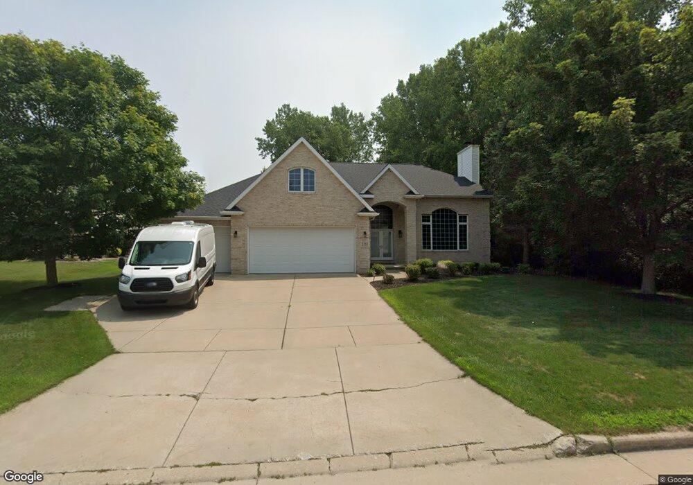
2181 Shady Ln Green Bay, WI 54313
Estimated Value: $542,780 - $602,000
5
Beds
3
Baths
3,138
Sq Ft
$181/Sq Ft
Est. Value
About This Home
This home is located at 2181 Shady Ln, Green Bay, WI 54313 and is currently estimated at $568,945, approximately $181 per square foot. 2181 Shady Ln is a home located in Brown County with nearby schools including Valley View Elementary School, Parkview Middle School, and Ashwaubenon High School.
Ownership History
Date
Name
Owned For
Owner Type
Purchase Details
Closed on
Jul 31, 2008
Sold by
Rockstroh Michael J and Rockstroh Molly A
Bought by
Wisneski Roger and Wisneski Jane
Current Estimated Value
Home Financials for this Owner
Home Financials are based on the most recent Mortgage that was taken out on this home.
Original Mortgage
$230,000
Outstanding Balance
$147,506
Interest Rate
5.87%
Mortgage Type
Purchase Money Mortgage
Estimated Equity
$421,439
Purchase Details
Closed on
Jan 30, 1998
Sold by
Krawczyk Roland R and Krawczyk Susan M
Bought by
Rockstroh Michael J and Rockstroh Molly A
Create a Home Valuation Report for This Property
The Home Valuation Report is an in-depth analysis detailing your home's value as well as a comparison with similar homes in the area
Home Values in the Area
Average Home Value in this Area
Purchase History
| Date | Buyer | Sale Price | Title Company |
|---|---|---|---|
| Wisneski Roger | $290,000 | Bay Title | |
| Rockstroh Michael J | $43,600 | Bay Title & Abstract Inc |
Source: Public Records
Mortgage History
| Date | Status | Borrower | Loan Amount |
|---|---|---|---|
| Open | Wisneski Roger | $230,000 |
Source: Public Records
Tax History Compared to Growth
Tax History
| Year | Tax Paid | Tax Assessment Tax Assessment Total Assessment is a certain percentage of the fair market value that is determined by local assessors to be the total taxable value of land and additions on the property. | Land | Improvement |
|---|---|---|---|---|
| 2024 | $6,736 | $471,100 | $71,000 | $400,100 |
| 2023 | $6,273 | $471,100 | $71,000 | $400,100 |
| 2022 | $6,075 | $372,500 | $60,600 | $311,900 |
| 2021 | $6,282 | $372,500 | $60,600 | $311,900 |
| 2020 | $5,605 | $312,700 | $57,400 | $255,300 |
| 2019 | $5,478 | $312,700 | $57,400 | $255,300 |
| 2018 | $5,409 | $280,200 | $54,700 | $225,500 |
| 2017 | $5,444 | $280,200 | $54,700 | $225,500 |
| 2016 | $5,497 | $280,200 | $54,700 | $225,500 |
| 2015 | $5,432 | $280,200 | $54,700 | $225,500 |
| 2014 | $5,774 | $280,200 | $54,700 | $225,500 |
| 2013 | $5,774 | $280,200 | $54,700 | $225,500 |
Source: Public Records
Map
Nearby Homes
- 1570 Mesa Dr
- 1445 Cormier Rd
- 1439 Cormier Rd
- 2060 Trissino Way
- 1514 Ashley Ct
- 2031 Bradbury Ln
- 2044 Ann Ln
- 1387 Cormier Rd
- 2466 Parkwood Dr
- 1680 Cormier Rd
- 2060 Wintergreen Ct
- 1450 Woodmont Way
- 1471 Parkway Dr
- 1371 View Ln
- 1973 Knotty Pine Dr
- 2445 Basswood St
- 1288 Canterbury Rd
- 2203 Gilson Ct
- 1307 Blue Ridge Dr
- 1217 Echo Ln
- 2175 Shady Ln
- 2170 S Courtland Dr
- 2171 Shady Ln
- 2176 Shady Ln
- 2174 S Courtland Dr
- 2180 Shady Ln
- 2166 S Courtland Dr
- 2161 Shady Ln
- 2170 Shady Ln
- 2160 Shady Ln
- 2160 S Courtland Dr
- 2175 S Courtland Dr
- 2151 Shady Ln
- 2150 Shady Ln
- 2150 S Courtland Dr
- 2171 S Courtland Dr
- 1515 Mesa Dr
- 2167 S Courtland Dr
- 2200 Balsam Way Unit BLOCK
- 2200 Balsam Way Unit BLOCK