
Seller's Agent in 2025
Tyler Stoltz
Berkshire Hathaway HomeServices Homesale Realty
(717) 201-5960
6 in this area
208 Total Sales
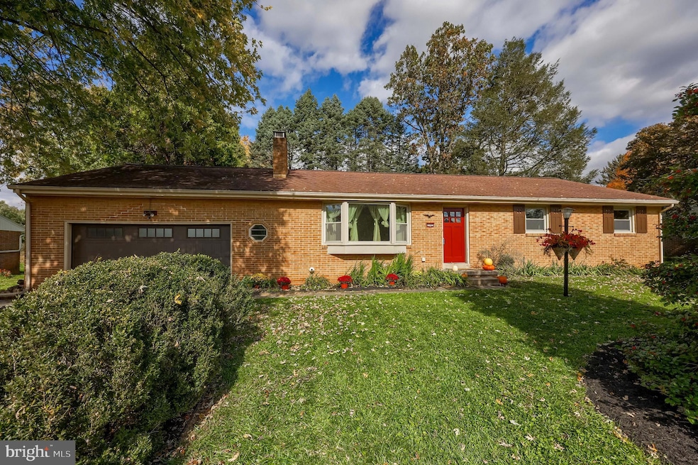


Welcome to 2183 Kolb Dr - An all brick, single-level ranch in a quiet neighborhood on a .29-acre lot. This 3 bedroom, 2 full bath home features an oversized 2 car garage (front & rear doors, extra storage/workspace), wood burning fireplace, central air, hardwood floors, and replaced double-hung windows throughout. Recent upgrades include a brand-new cooktop, garage door, and a new water-softening system. First floor bedrooms, multiple bathrooms AND laundry offers true, first floor living. Generously sized bedrooms, full attic and a large dry basement with bonus/workshop/utility space ready for finishing. Beautiful perennial gardens provide four season color. Walking distance to Fritz Elementary and offering easy access to Rte 30 and Rte 222, as well as Lancaster City. 2183 Kolb Drive is a rare find. Beautifully built, lovingly maintained, and ready for its next chapter. Schedule your private tour today and experience all this remarkable home has to offer!
Last Agent to Sell the Property
(717) 560-9100 tstoltz@homesale.com Berkshire Hathaway HomeServices Homesale Realty License #RS339473 Listed on: 10/31/2025
| Date | Type | Sale Price | Title Company |
|---|---|---|---|
| Deed | $376,000 | Capstone Agent Transfer Servic | |
| Deed | $210,000 | None Available |
| Date | Status | Loan Amount | Loan Type |
|---|---|---|---|
| Open | $357,200 | New Conventional | |
| Previous Owner | $168,000 | Fannie Mae Freddie Mac |
| Date | Event | Price | List to Sale | Price per Sq Ft |
|---|---|---|---|---|
| 11/28/2025 11/28/25 | Sold | $376,000 | +7.7% | $245 / Sq Ft |
| 11/03/2025 11/03/25 | Pending | -- | -- | -- |
| 10/31/2025 10/31/25 | For Sale | $349,000 | -- | $227 / Sq Ft |
| Year | Tax Paid | Tax Assessment Tax Assessment Total Assessment is a certain percentage of the fair market value that is determined by local assessors to be the total taxable value of land and additions on the property. | Land | Improvement |
|---|---|---|---|---|
| 2025 | $3,743 | $184,900 | $51,500 | $133,400 |
| 2024 | $3,743 | $184,900 | $51,500 | $133,400 |
| 2023 | $3,657 | $184,900 | $51,500 | $133,400 |
| 2022 | $3,566 | $184,900 | $51,500 | $133,400 |
| 2021 | $3,440 | $184,900 | $51,500 | $133,400 |
| 2020 | $3,440 | $184,900 | $51,500 | $133,400 |
| 2019 | $3,366 | $184,900 | $51,500 | $133,400 |
| 2018 | $4,761 | $184,900 | $51,500 | $133,400 |
| 2017 | $3,252 | $150,200 | $41,700 | $108,500 |
| 2016 | $3,213 | $150,200 | $41,700 | $108,500 |
| 2015 | $821 | $150,200 | $41,700 | $108,500 |
| 2014 | $2,132 | $150,200 | $41,700 | $108,500 |
Seller's Agent in 2025
Tyler Stoltz
Berkshire Hathaway HomeServices Homesale Realty
(717) 201-5960
6 in this area
208 Total Sales
Buyer's Agent in 2025
Michael Stoltzfus
Coldwell Banker Realty
(717) 380-3367
2 in this area
110 Total Sales
Source: Bright MLS
MLS Number: PALA2078722
APN: 310-23407-0-0000
Disclaimer: Certain information contained herein is derived from information provided by parties other than Homes.com. All information provided is deemed reliable, but is not guaranteed to be accurate and should be independently verified.
![]() The data relating to real estate for sale on this website appears in part through the BRIGHT Internet Data Exchange program, a voluntary cooperative exchange of property listing data between licensed real estate brokerage firms, and is provided by BRIGHT through a licensing agreement.
The data relating to real estate for sale on this website appears in part through the BRIGHT Internet Data Exchange program, a voluntary cooperative exchange of property listing data between licensed real estate brokerage firms, and is provided by BRIGHT through a licensing agreement.
Listing information is from various brokers who participate in the Bright MLS IDX program and not all listings may be visible on the site.
The property information being provided on or through the website is for the personal, non-commercial use of consumers and such information may not be used for any purpose other than to identify prospective properties consumers may be interested in purchasing.
Some properties which appear for sale on the website may no longer be available because they are for instance, under contract, sold or are no longer being offered for sale.
Property information displayed is deemed reliable but is not guaranteed.
Copyright 2026 Bright MLS, Inc.
Ask me questions while you tour the home.