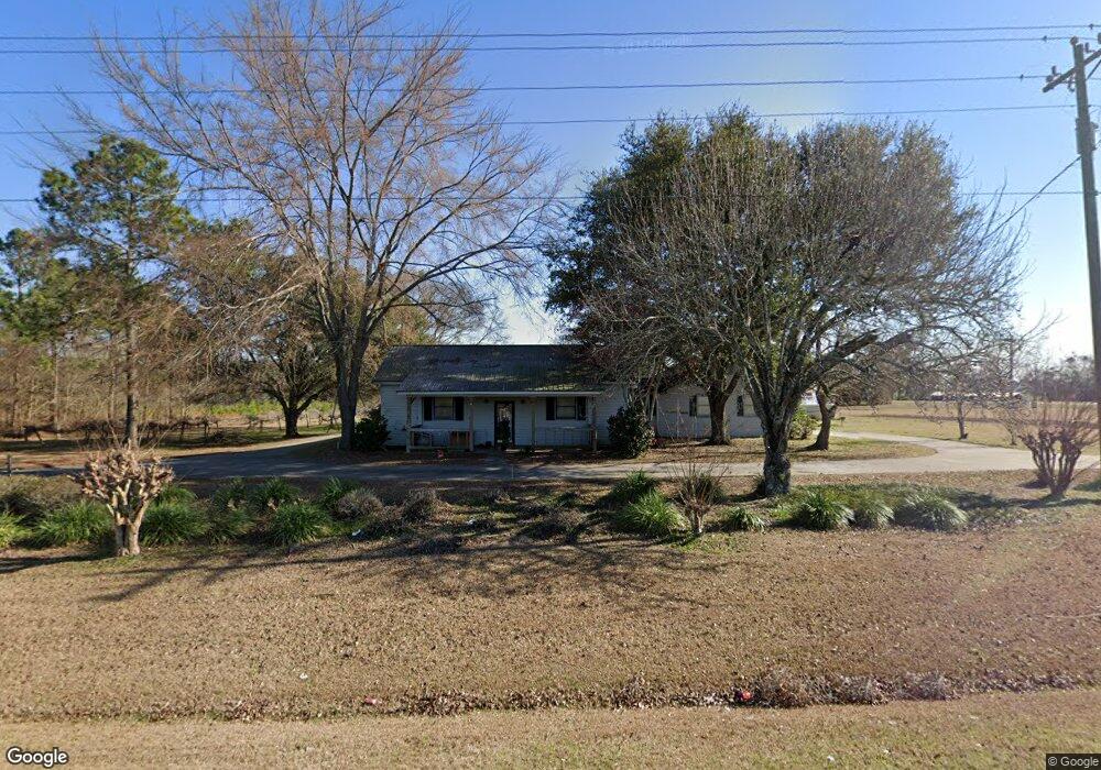
2185 Ga Highway 111 Moultrie, GA 31768
Estimated Value: $209,000 - $218,000
--
Bed
2
Baths
1,906
Sq Ft
$112/Sq Ft
Est. Value
About This Home
This home is located at 2185 Ga Highway 111, Moultrie, GA 31768 and is currently estimated at $214,061, approximately $112 per square foot. 2185 Ga Highway 111 is a home located in Colquitt County with nearby schools including Hamilton Elementary School, C.A. Gray Junior High School, and Willie J. Williams Middle School.
Ownership History
Date
Name
Owned For
Owner Type
Purchase Details
Closed on
May 10, 2018
Sold by
Rodgers
Bought by
Sloan William
Current Estimated Value
Home Financials for this Owner
Home Financials are based on the most recent Mortgage that was taken out on this home.
Original Mortgage
$99,071
Outstanding Balance
$87,350
Interest Rate
5.5%
Mortgage Type
FHA
Estimated Equity
$126,712
Purchase Details
Closed on
Jan 19, 2000
Sold by
Rodgers W Ralph
Bought by
Rodgers W Ralph Sr Life
Purchase Details
Closed on
Nov 18, 1986
Bought by
Rodgers W Ralph
Create a Home Valuation Report for This Property
The Home Valuation Report is an in-depth analysis detailing your home's value as well as a comparison with similar homes in the area
Home Values in the Area
Average Home Value in this Area
Purchase History
| Date | Buyer | Sale Price | Title Company |
|---|---|---|---|
| Sloan William | $100,900 | -- | |
| Rodgers W Ralph Sr Life | -- | -- | |
| Rodgers W Ralph | $22,000 | -- |
Source: Public Records
Mortgage History
| Date | Status | Borrower | Loan Amount |
|---|---|---|---|
| Open | Sloan William | $99,071 |
Source: Public Records
Tax History Compared to Growth
Tax History
| Year | Tax Paid | Tax Assessment Tax Assessment Total Assessment is a certain percentage of the fair market value that is determined by local assessors to be the total taxable value of land and additions on the property. | Land | Improvement |
|---|---|---|---|---|
| 2024 | $1,337 | $69,246 | $8,451 | $60,795 |
| 2023 | $1,418 | $57,120 | $8,451 | $48,669 |
| 2022 | $1,192 | $52,051 | $7,512 | $44,539 |
| 2021 | $1,090 | $46,884 | $7,512 | $39,372 |
| 2020 | $1,044 | $44,245 | $7,512 | $36,733 |
| 2019 | $1,067 | $42,485 | $7,512 | $34,973 |
| 2018 | $890 | $34,782 | $7,512 | $27,270 |
| 2017 | $881 | $32,363 | $5,093 | $27,270 |
| 2016 | $893 | $32,363 | $5,093 | $27,270 |
| 2015 | $901 | $32,363 | $5,093 | $27,270 |
| 2014 | $884 | $32,363 | $5,093 | $27,270 |
| 2013 | -- | $32,362 | $5,092 | $27,270 |
Source: Public Records
Map
Nearby Homes
- 0 Kendallwood Dr Unit 1652301
- 182 Mcginty Rd
- 219 Cox Dairy Rd
- 198 Westwoods Dr
- 2393 Georgia 37
- Lot 45 Fox Trot Dr
- 0 Fox Trot Dr
- LOT 23 Westwoods Dr
- LOT 30 Merganser Ln
- 216 Circle Rd
- 372 Westwoods Dr Unit 21
- 2010 West Blvd
- 1215 12th St SW
- 0 Gatewood Cir Unit 1652303
- 904 Barbara Cir
- 905 Barbara Cir
- 39 Hummingbird Rd
- 1321 Hallmark Dr
- Lot 3 Hummingbird Ln
- 10 Hummingbird Rd
- 1975 Kendallwood Church Rd
- 2151 Ga Highway 111
- 1976 Kendallwood Church Rd
- 1994 Kendallwood Church Rd
- 2273 Ga Highway 111
- KENDALLWO0D Kendallwood Church Rd
- 2294 Ga Highway 111
- 2067 Ga Highway 111
- 109 Kendallwood Dr
- 2058 Ga Highway 111
- 121 Ashen Ct
- 131 Kendallwood Dr
- 143 Kendallwood Dr
- 166 Fireplace Ln
- 1755 Kendallwood Church Rd
- 2047 Ga Highway 111
- 471 Kendallwood Dr
- 447 Kendallwood Dr
- 111 Fireplace Ln
- 423 Kendallwood Dr