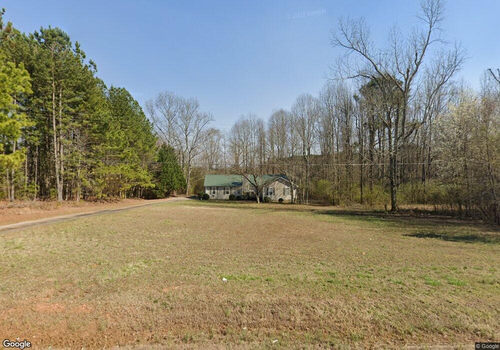
2187 Highway 82 Statham, GA 30666
Estimated Value: $299,000 - $349,000
--
Bed
2
Baths
1,457
Sq Ft
$219/Sq Ft
Est. Value
About This Home
This home is located at 2187 Highway 82, Statham, GA 30666 and is currently estimated at $318,864, approximately $218 per square foot. 2187 Highway 82 is a home located in Barrow County with nearby schools including Statham Elementary School, Bear Creek Middle School, and Winder-Barrow High School.
Ownership History
Date
Name
Owned For
Owner Type
Purchase Details
Closed on
Jun 27, 2014
Sold by
Murrell Tommy J
Bought by
Dunahoo Judy R
Current Estimated Value
Purchase Details
Closed on
Apr 24, 1998
Sold by
Dunahoo W T
Bought by
Murrell Tommy J
Home Financials for this Owner
Home Financials are based on the most recent Mortgage that was taken out on this home.
Original Mortgage
$80,000
Interest Rate
7.09%
Mortgage Type
New Conventional
Create a Home Valuation Report for This Property
The Home Valuation Report is an in-depth analysis detailing your home's value as well as a comparison with similar homes in the area
Home Values in the Area
Average Home Value in this Area
Purchase History
| Date | Buyer | Sale Price | Title Company |
|---|---|---|---|
| Dunahoo Judy R | -- | -- | |
| Murrell Tommy J | $80,000 | -- |
Source: Public Records
Mortgage History
| Date | Status | Borrower | Loan Amount |
|---|---|---|---|
| Previous Owner | Murrell Tommy J | $80,000 |
Source: Public Records
Tax History Compared to Growth
Tax History
| Year | Tax Paid | Tax Assessment Tax Assessment Total Assessment is a certain percentage of the fair market value that is determined by local assessors to be the total taxable value of land and additions on the property. | Land | Improvement |
|---|---|---|---|---|
| 2024 | $1,692 | $78,644 | $16,000 | $62,644 |
| 2023 | $1,269 | $78,644 | $16,000 | $62,644 |
| 2022 | $1,358 | $53,241 | $16,000 | $37,241 |
| 2021 | $1,251 | $46,171 | $12,000 | $34,171 |
| 2020 | $1,130 | $41,068 | $10,000 | $31,068 |
| 2019 | $1,148 | $41,068 | $10,000 | $31,068 |
| 2018 | $1,126 | $41,068 | $10,000 | $31,068 |
| 2017 | $1,054 | $36,214 | $10,000 | $26,214 |
| 2016 | $989 | $36,528 | $10,000 | $26,528 |
| 2015 | $1,011 | $37,158 | $10,000 | $27,158 |
| 2014 | $868 | $32,373 | $4,900 | $27,473 |
| 2013 | -- | $31,063 | $4,900 | $26,163 |
Source: Public Records
Map
Nearby Homes
- 3845 S Highway 82
- 0 Georgia 330
- 1914 Hearthstone Ct
- 1916 Hearthstone Ct
- 1917 Hearthstone Ct
- 310 Jacobs Ln
- 126 Old Indian Trail
- 1642 White Oak Dr
- 1415 Red Oak Way
- 1423 Red Oak Way
- 1955 Paynes Point
- 0 Old Hunter Rd Unit TRACT 5
- 0 Old Hunter Rd Unit TRACT 3 10552618
- 3036 Johnson-Hale Rd
- 0 Old Hunter Road Tract 3
- 0 Old Hunter Road Tract 5
- 207 Cedar Grove Church Rd
- 308 Kinsley Way
- 1593 Highway 82