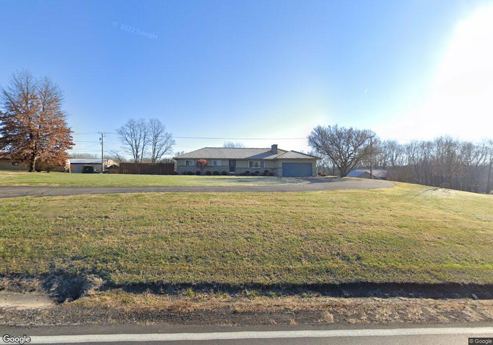
2188 State Route 13 NE New Lexington, OH 43764
Estimated Value: $225,000
5
Beds
5
Baths
2,862
Sq Ft
$79/Sq Ft
Est. Value
About This Home
This home is located at 2188 State Route 13 NE, New Lexington, OH 43764 and is currently estimated at $225,000, approximately $78 per square foot. 2188 State Route 13 NE is a home located in Perry County with nearby schools including New Lexington Elementary School, Junction City Elementary School, and New Lexington Middle School.
Ownership History
Date
Name
Owned For
Owner Type
Purchase Details
Closed on
Jun 5, 2019
Sold by
Stephens Anthony and Stephens Amanda
Bought by
Epifano James R and Epifano James V
Current Estimated Value
Purchase Details
Closed on
Jan 14, 2019
Sold by
Epifano James V
Bought by
Epifano James V and Epifano James R
Purchase Details
Closed on
Sep 14, 2018
Sold by
Epifano James R
Bought by
Epifano James V
Purchase Details
Closed on
Jun 28, 2018
Sold by
Epifano James R and Epifano Rhonda
Bought by
Stephens Anthony and Stephens Amanda
Create a Home Valuation Report for This Property
The Home Valuation Report is an in-depth analysis detailing your home's value as well as a comparison with similar homes in the area
Home Values in the Area
Average Home Value in this Area
Purchase History
| Date | Buyer | Sale Price | Title Company |
|---|---|---|---|
| Epifano James R | $3,595 | Van Horn Title | |
| Epifano James V | -- | None Available | |
| Epifano James V | -- | None Available | |
| Stephens Anthony | $3,595 | Van Horn Title | |
| Epifano James R | -- | None Available | |
| Epifano James R | -- | Van Horn Title Agency | |
| Van Horn Title Agency Inc | -- | Van Horn Title |
Source: Public Records
Tax History Compared to Growth
Tax History
| Year | Tax Paid | Tax Assessment Tax Assessment Total Assessment is a certain percentage of the fair market value that is determined by local assessors to be the total taxable value of land and additions on the property. | Land | Improvement |
|---|---|---|---|---|
| 2024 | $33 | $770 | $770 | $0 |
| 2023 | $33 | $770 | $770 | $0 |
| 2022 | $23 | $440 | $440 | $0 |
| 2021 | $22 | $440 | $440 | $0 |
| 2020 | $25 | $440 | $440 | $0 |
| 2019 | $19 | $380 | $380 | $0 |
| 2018 | $19 | $380 | $380 | $0 |
| 2017 | $1,588 | $37,260 | $10,560 | $26,700 |
| 2016 | $1,844 | $48,550 | $13,300 | $35,250 |
| 2015 | $1,840 | $48,550 | $13,300 | $35,250 |
| 2014 | $1,729 | $48,550 | $13,300 | $35,250 |
| 2013 | $1,499 | $45,770 | $12,110 | $33,660 |
| 2012 | -- | $42,390 | $8,730 | $33,660 |
Source: Public Records
Map
Nearby Homes
- 418 W Broadway St Unit Rear
- 221 W Broadway St
- 210 Academy St
- 318 N Pleasant St
- 836 Johnson Ave
- 2755 Old Somerset Rd
- 200 N Main St
- 551 W Brown St
- 314 W Brown St
- 524 Shawnee St
- 603 Shawnee St
- 227 Park Ave
- 211 S High St
- 218 Park Ave
- 398 North Ave
- 412 Church St
- 105 S Maple Heights
- 263 S Maple Heights
- 522 S Main St
- 1893 Lovers Ln
- 2188 State Route 13 NE
- 2136 State Route 13 NE
- 2135 State Route 13 NE
- 2120 State Route 13 NE
- 209 Reading St
- 6126 County Road 113
- 410 W Lincoln St
- 500 W Broadway St
- 320 W Lincoln St
- 160 Imperial St
- 318 W Lincoln St
- 430 W Broadway St
- 314 W Lincoln St
- 420 W Broadway St
- 148 Imperial St
- 161 Imperial St
- 158 Somerset St
- 322 Reading St
- 418 W Broadway St
- 310 W Lincoln St