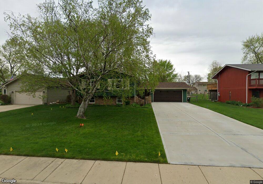
219 April Ln North Aurora, IL 60542
Estimated Value: $288,000 - $350,413
4
Beds
2
Baths
2,422
Sq Ft
$131/Sq Ft
Est. Value
About This Home
This home is located at 219 April Ln, North Aurora, IL 60542 and is currently estimated at $318,353, approximately $131 per square foot. 219 April Ln is a home located in Kane County with nearby schools including Schneider Elementary School, Herget Middle School, and West Aurora High School.
Ownership History
Date
Name
Owned For
Owner Type
Purchase Details
Closed on
Oct 1, 2020
Sold by
Barton Derek and Barton Gwendolyn
Bought by
Barton Derek and Barton Gwendolyn
Current Estimated Value
Home Financials for this Owner
Home Financials are based on the most recent Mortgage that was taken out on this home.
Original Mortgage
$157,000
Outstanding Balance
$112,476
Interest Rate
2.75%
Mortgage Type
New Conventional
Estimated Equity
$205,877
Purchase Details
Closed on
Jun 15, 2007
Sold by
Hester Daniel L and Hester Karen E
Bought by
Barton Derek and Deblois Gwendolyn
Home Financials for this Owner
Home Financials are based on the most recent Mortgage that was taken out on this home.
Original Mortgage
$187,200
Interest Rate
6.37%
Mortgage Type
Purchase Money Mortgage
Purchase Details
Closed on
Mar 1, 1999
Sold by
Mcmanus Patrick J and Mcmanus Joann M
Bought by
Hester Daniel L and Hester Karen E
Purchase Details
Closed on
Aug 23, 1996
Sold by
Howrey James M and Howrey Mary M
Bought by
Mcmanus Patrick J and Mcmanus Joann
Home Financials for this Owner
Home Financials are based on the most recent Mortgage that was taken out on this home.
Original Mortgage
$58,500
Interest Rate
8.3%
Create a Home Valuation Report for This Property
The Home Valuation Report is an in-depth analysis detailing your home's value as well as a comparison with similar homes in the area
Home Values in the Area
Average Home Value in this Area
Purchase History
| Date | Buyer | Sale Price | Title Company |
|---|---|---|---|
| Barton Derek | -- | None Available | |
| Barton Derek | $234,000 | Fatc | |
| Hester Daniel L | $149,000 | Law Title Insurance Co Inc | |
| Mcmanus Patrick J | $140,500 | Law Title Insurance Co Inc |
Source: Public Records
Mortgage History
| Date | Status | Borrower | Loan Amount |
|---|---|---|---|
| Open | Barton Derek | $157,000 | |
| Previous Owner | Barton Derek | $187,200 | |
| Previous Owner | Mcmanus Patrick J | $58,500 |
Source: Public Records
Tax History Compared to Growth
Tax History
| Year | Tax Paid | Tax Assessment Tax Assessment Total Assessment is a certain percentage of the fair market value that is determined by local assessors to be the total taxable value of land and additions on the property. | Land | Improvement |
|---|---|---|---|---|
| 2024 | $5,780 | $84,898 | $11,007 | $73,891 |
| 2023 | $5,619 | $77,054 | $9,990 | $67,064 |
| 2022 | $4,984 | $66,315 | $9,336 | $56,979 |
| 2021 | $4,837 | $62,893 | $8,854 | $54,039 |
| 2020 | $4,817 | $61,684 | $8,684 | $53,000 |
| 2019 | $4,864 | $59,501 | $8,377 | $51,124 |
| 2018 | $4,816 | $57,235 | $8,058 | $49,177 |
| 2017 | $4,739 | $55,347 | $7,792 | $47,555 |
| 2016 | $4,723 | $53,735 | $7,565 | $46,170 |
| 2015 | -- | $52,512 | $7,393 | $45,119 |
| 2014 | -- | $50,859 | $7,160 | $43,699 |
| 2013 | -- | $51,873 | $9,360 | $42,513 |
Source: Public Records
Map
Nearby Homes
- 215 Dee Rd
- 254 Ridge Rd
- 302 Dee Rd
- 114 Briar Ln Unit 2
- 105 April Ln Unit 2
- 203 Lilac Ln
- 273 Ridley St
- 202 Linn Ct Unit C
- 719 Pinecreek Dr
- 616 Pinehurst Dr
- 509 Wingfoot Dr
- 122 E State St
- 925 Darwin St
- 148 N Lincolnway
- 24 S Grant St
- 810 Columbia Cir Unit 3
- 12 N Lincolnway
- 355 Hilltop Dr
- 218 Timber Oaks Dr
- 344 Hilltop Dr