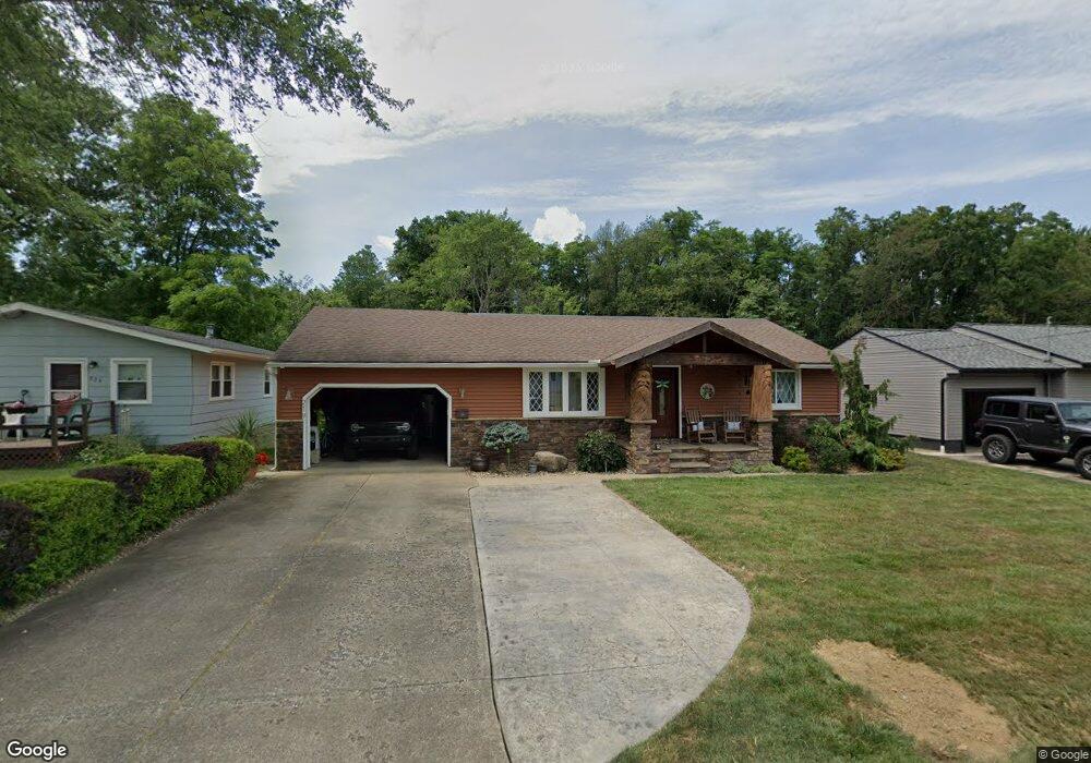
219 Bonnieview Ave Alliance, OH 44601
Estimated Value: $163,000 - $209,000
4
Beds
2
Baths
1,440
Sq Ft
$123/Sq Ft
Est. Value
About This Home
This home is located at 219 Bonnieview Ave, Alliance, OH 44601 and is currently estimated at $177,302, approximately $123 per square foot. 219 Bonnieview Ave is a home located in Stark County with nearby schools including Alliance Early Learning School, Alliance Intermediate School at Northside, and Alliance Middle School.
Ownership History
Date
Name
Owned For
Owner Type
Purchase Details
Closed on
Nov 9, 1995
Sold by
Gorby Kevin
Bought by
Trautman Fred W and Trautman Lynne
Current Estimated Value
Home Financials for this Owner
Home Financials are based on the most recent Mortgage that was taken out on this home.
Original Mortgage
$71,250
Outstanding Balance
$1,006
Interest Rate
7.7%
Mortgage Type
New Conventional
Estimated Equity
$176,296
Purchase Details
Closed on
May 11, 1989
Create a Home Valuation Report for This Property
The Home Valuation Report is an in-depth analysis detailing your home's value as well as a comparison with similar homes in the area
Home Values in the Area
Average Home Value in this Area
Purchase History
| Date | Buyer | Sale Price | Title Company |
|---|---|---|---|
| Trautman Fred W | $75,000 | -- | |
| -- | $45,500 | -- |
Source: Public Records
Mortgage History
| Date | Status | Borrower | Loan Amount |
|---|---|---|---|
| Open | Trautman Fred W | $71,250 |
Source: Public Records
Tax History Compared to Growth
Tax History
| Year | Tax Paid | Tax Assessment Tax Assessment Total Assessment is a certain percentage of the fair market value that is determined by local assessors to be the total taxable value of land and additions on the property. | Land | Improvement |
|---|---|---|---|---|
| 2025 | -- | $49,850 | $7,390 | $42,460 |
| 2024 | -- | $49,850 | $7,390 | $42,460 |
| 2023 | $1,596 | $39,730 | $5,500 | $34,230 |
| 2022 | $1,607 | $39,730 | $5,500 | $34,230 |
| 2021 | $1,609 | $39,730 | $5,500 | $34,230 |
| 2020 | $1,463 | $33,740 | $4,760 | $28,980 |
| 2019 | $1,442 | $33,740 | $4,760 | $28,980 |
| 2018 | $1,449 | $33,740 | $4,760 | $28,980 |
| 2017 | $1,425 | $32,660 | $4,900 | $27,760 |
| 2016 | $1,332 | $30,280 | $6,130 | $24,150 |
| 2015 | $1,344 | $30,280 | $6,130 | $24,150 |
| 2014 | $1,379 | $29,580 | $5,990 | $23,590 |
| 2013 | $688 | $29,580 | $5,990 | $23,590 |
Source: Public Records
Map
Nearby Homes
- 565 W Broadway St
- 725 W Summit St
- 734 Parkway Blvd
- 345 W Market St
- 645 W Summit St
- 329 1/2 W Main St
- 511 W Ely St
- 432 Johnson Ave
- 896 Parkway Blvd
- 132 S Haines Ave
- 163 W Market St
- 970 Kingsway St
- 738 Kingsway St
- 1038 Fairview Place
- 140 W Summit St
- 000 Klinger Ave
- 427 S Union Ave
- 1321 Parkway Blvd
- 0 W Main St Unit 5090123
- 1201 Overlook Dr
- 229 Bonnieview Ave
- 209 Bonnieview Ave
- 239 Bonnieview Ave
- 179 Bonnieview Ave
- 220 Bonnieview Ave
- 210 Bonnieview Ave
- 251 Bonnieview Ave
- 230 Bonnieview Ave
- 159 Bonnieview Ave
- 244 Bonnieview Ave
- 265 Bonnieview Ave
- 160 Bonnieview Ave
- 139 Bonnieview Ave
- 967 W Broadway St
- 309 Bonnieview Ave
- 140 Bonnieview Ave
- 304 Bonnieview Ave
- 119 Bonnieview Ave
- 959 W Broadway St
- 325 Bonnieview Ave