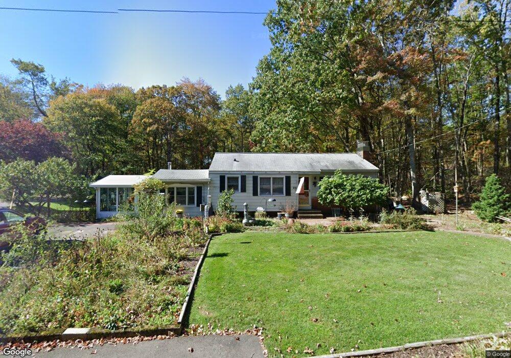
219 Cedar Swamp Rd Coventry, CT 06238
Estimated Value: $313,000 - $344,000
3
Beds
2
Baths
1,164
Sq Ft
$279/Sq Ft
Est. Value
About This Home
This home is located at 219 Cedar Swamp Rd, Coventry, CT 06238 and is currently estimated at $324,343, approximately $278 per square foot. 219 Cedar Swamp Rd is a home located in Tolland County with nearby schools including Coventry Grammar School, George Hersey Robertson School, and Capt. Nathan Hale School.
Ownership History
Date
Name
Owned For
Owner Type
Purchase Details
Closed on
Sep 27, 2017
Sold by
Duffy Robert J and Duffy Joy E
Bought by
Healy Kelly S
Current Estimated Value
Purchase Details
Closed on
Aug 22, 2017
Sold by
Duffy Robert J and Duffy Joy E
Bought by
Fuller Kimberly J
Purchase Details
Closed on
Aug 8, 1973
Bought by
Duffy Robert J
Create a Home Valuation Report for This Property
The Home Valuation Report is an in-depth analysis detailing your home's value as well as a comparison with similar homes in the area
Home Values in the Area
Average Home Value in this Area
Purchase History
| Date | Buyer | Sale Price | Title Company |
|---|---|---|---|
| Healy Kelly S | -- | -- | |
| Fuller Kimberly J | -- | -- | |
| Duffy Robert J | -- | -- | |
| Healy Kelly S | -- | -- | |
| Fuller Kimberly J | -- | -- |
Source: Public Records
Mortgage History
| Date | Status | Borrower | Loan Amount |
|---|---|---|---|
| Previous Owner | Duffy Robert J | $70,000 |
Source: Public Records
Tax History
| Year | Tax Paid | Tax Assessment Tax Assessment Total Assessment is a certain percentage of the fair market value that is determined by local assessors to be the total taxable value of land and additions on the property. | Land | Improvement |
|---|---|---|---|---|
| 2025 | $4,367 | $183,800 | $50,800 | $133,000 |
| 2024 | $3,687 | $110,700 | $41,900 | $68,800 |
| 2023 | $3,514 | $110,700 | $41,900 | $68,800 |
| 2022 | $3,448 | $110,700 | $41,900 | $68,800 |
| 2021 | $3,448 | $110,700 | $41,900 | $68,800 |
| 2020 | $3,451 | $110,700 | $41,900 | $68,800 |
| 2019 | $3,565 | $110,700 | $41,900 | $68,800 |
| 2018 | $3,375 | $104,800 | $41,900 | $62,900 |
| 2017 | $3,354 | $104,800 | $41,900 | $62,900 |
| 2016 | $3,270 | $104,800 | $41,900 | $62,900 |
| 2015 | $3,270 | $104,800 | $41,900 | $62,900 |
| 2014 | $3,428 | $120,400 | $51,100 | $69,300 |
Source: Public Records
Map
Nearby Homes
- 23 Neville St
- 5 Laurelwood Ln Unit lot 16
- 7 Laurelwood Ln Unit Lot 15
- 12 Laurelwood Ln Unit lot 8
- 939 Boston Turnpike
- 61 Stone Hedge Ln
- 0 Boston Turnpike Unit 24128587
- 279 Mark Dr
- 687 Hop River Rd
- 25 Wolf Hill Rd
- 37 Wolf Hill Rd Unit Lot 40
- 37 Wolf Hill Lot (#40) Rd
- 93 Dockerel Rd
- 151 Pine Hill Rd
- 395 Grant Hill (Mill Race Drive) Lot #21 Rd
- 395 Grant Hill Rd Unit Lot21
- 361 Dunn Rd
- 16 Higgins Way
- 612 Broad Way
- 2 Vine Dr
- 209 Cedar Swamp Rd
- 228 Cedar Swamp Rd
- 250 Cedar Swamp Rd
- 240 Cedar Swamp Rd
- 260 Cedar Swamp Rd
- 181 Cedar Swamp Rd
- 276 Cedar Swamp Rd
- 271 Cedar Swamp Rd
- 190 Cedar Swamp Rd
- 201 Cedar Swamp Rd
- 285 Cedar Swamp Rd
- 177 Cedar Swamp Rd
- 195 Cedar Swamp Rd
- 166 Cedar Swamp Rd
- 300 Cedar Swamp Rd
- 155 Cedar Swamp Rd
- 293 Cedar Swamp Rd
- 307 Cedar Swamp Rd
- 146 Cedar Swamp Rd
- 299 Cedar Swamp Rd
Your Personal Tour Guide
Ask me questions while you tour the home.