Estimated Value: $267,797 - $312,000
Studio
--
Bath
1,008
Sq Ft
$289/Sq Ft
Est. Value
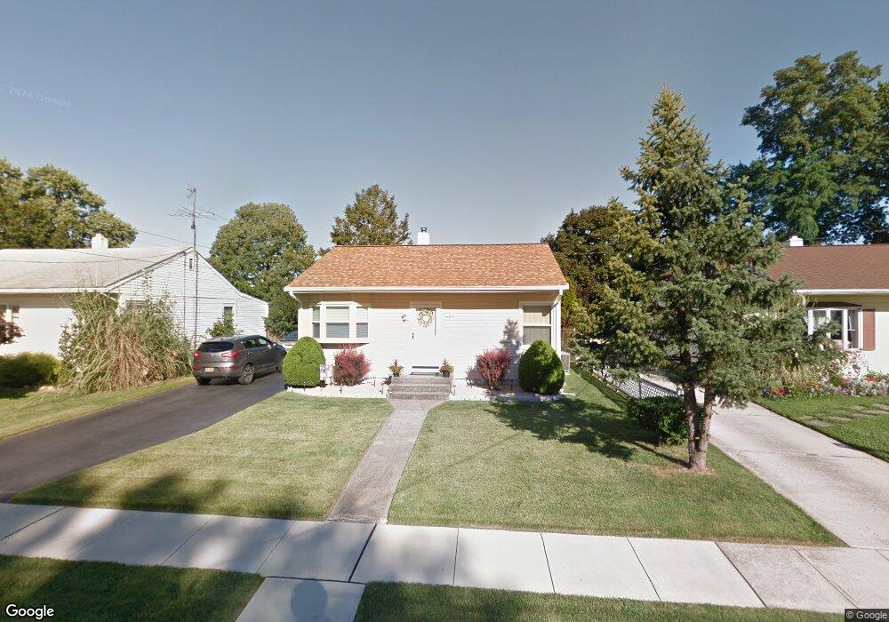
About This Home
This home is located at 219 Clamer Rd, Ewing, NJ 08628 and is currently estimated at $291,699, approximately $289 per square foot. 219 Clamer Rd is a home located in Mercer County with nearby schools including Ewing High School, The Village Charter School, and Christina Seix Academy.
Ownership History
Date
Name
Owned For
Owner Type
Purchase Details
Closed on
Apr 29, 1997
Sold by
Albertson Robert
Bought by
Dix Robert and Russell Sandra
Current Estimated Value
Home Financials for this Owner
Home Financials are based on the most recent Mortgage that was taken out on this home.
Original Mortgage
$93,000
Outstanding Balance
$12,573
Interest Rate
7.85%
Mortgage Type
Purchase Money Mortgage
Estimated Equity
$279,126
Purchase Details
Closed on
Nov 25, 1991
Sold by
Moore Winifred Helene
Bought by
Kalbertson Robert F and Kalbertson Claudia
Create a Home Valuation Report for This Property
The Home Valuation Report is an in-depth analysis detailing your home's value as well as a comparison with similar homes in the area
Home Values in the Area
Average Home Value in this Area
Purchase History
| Date | Buyer | Sale Price | Title Company |
|---|---|---|---|
| Dix Robert | $89,000 | -- | |
| Kalbertson Robert F | $96,000 | -- |
Source: Public Records
Mortgage History
| Date | Status | Borrower | Loan Amount |
|---|---|---|---|
| Open | Dix Robert | $93,000 |
Source: Public Records
Tax History
| Year | Tax Paid | Tax Assessment Tax Assessment Total Assessment is a certain percentage of the fair market value that is determined by local assessors to be the total taxable value of land and additions on the property. | Land | Improvement |
|---|---|---|---|---|
| 2025 | $6,151 | $156,400 | $52,800 | $103,600 |
| 2024 | $5,782 | $156,400 | $52,800 | $103,600 |
| 2023 | $5,782 | $156,400 | $52,800 | $103,600 |
| 2022 | $5,626 | $156,400 | $52,800 | $103,600 |
| 2021 | $5,488 | $156,400 | $52,800 | $103,600 |
| 2020 | $5,410 | $156,400 | $52,800 | $103,600 |
| 2019 | $5,269 | $156,400 | $52,800 | $103,600 |
| 2018 | $5,118 | $96,900 | $44,600 | $52,300 |
| 2017 | $5,237 | $96,900 | $44,600 | $52,300 |
| 2016 | $5,167 | $96,900 | $44,600 | $52,300 |
| 2015 | $5,098 | $96,900 | $44,600 | $52,300 |
| 2014 | $5,084 | $96,900 | $44,600 | $52,300 |
Source: Public Records
Map
Nearby Homes
- 152 Franklyn Rd
- 322 Wynnewood Rd
- 860 Lower Ferry Rd Unit 5P
- 860 Lower Ferry Rd Unit 4C
- 860 Lower Ferry Rd Unit 2K
- 860 Lower Ferry Rd Unit 6M
- 1200 Silvia St
- 33 Stratford Ave
- 25 Preston Ave
- 22 Farrell Ave
- 1060 Terrace Blvd
- 1183 Lower Ferry Rd
- 126 Rutledge Ave
- 15 Decou Ave
- 768 Parkway Ave
- 6 Michelle Ct
- 16 Ranchwood Dr
- 41 Harding St
- 24 Glen Stewart Dr
- 9 Weston Rd
Your Personal Tour Guide
Ask me questions while you tour the home.