Estimated Value: $277,000 - $289,439
3
Beds
3
Baths
1,884
Sq Ft
$151/Sq Ft
Est. Value
About This Home
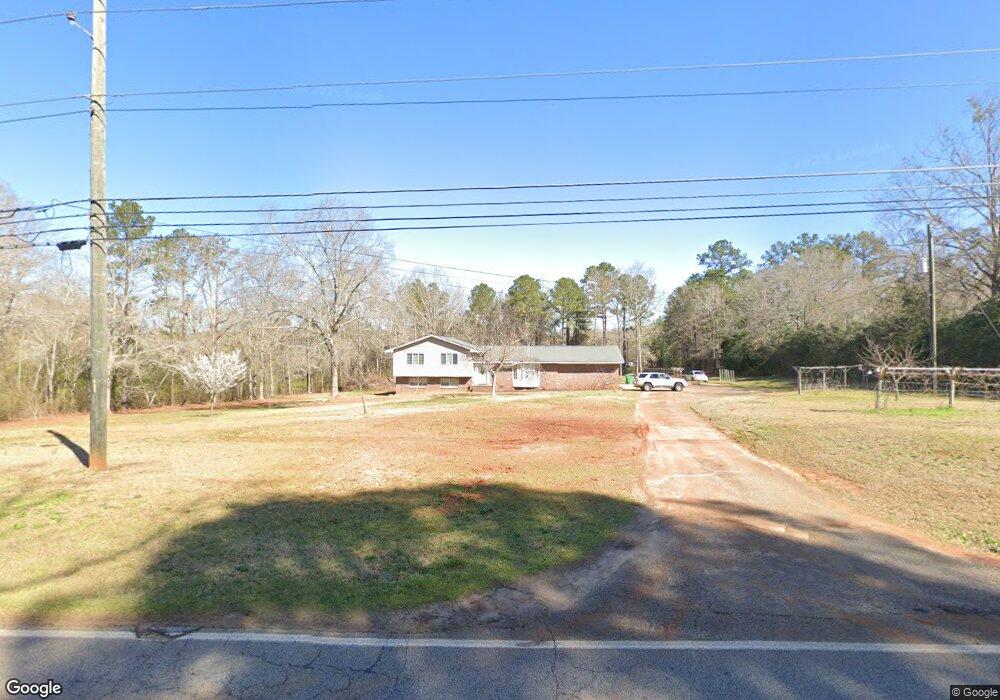
This home is located at 219 Langston Rd, Perry, GA 31069 and is currently estimated at $283,610, approximately $150 per square foot. 219 Langston Rd is a home located in Houston County with nearby schools including Langston Road Elementary School, Mossy Creek Middle School, and Perry High School.
Ownership History
Date
Name
Owned For
Owner Type
Purchase Details
Closed on
Feb 13, 2025
Sold by
Gaff Family Irrevocable Trust and Gaff Gregory W
Bought by
Gaff Jeffery D
Current Estimated Value
Purchase Details
Closed on
Jul 12, 2019
Sold by
Gaff J Wendell and Gaff Mary M
Bought by
Gaff Gregory W and Gaff Jeffery D
Purchase Details
Closed on
Mar 9, 2001
Sold by
Grant Bruce G and Grant Elizabeth R
Bought by
Mary Gaff J and Mary M*
Purchase Details
Closed on
May 16, 1979
Sold by
Walston Alton B and Walston Frankie A
Bought by
Grant Bruce G and Grant Elizabeth R
Purchase Details
Closed on
Feb 20, 1976
Sold by
Little Elizabeth F
Bought by
Walston Alton B and Walston Frankie A
Purchase Details
Closed on
Aug 23, 1972
Sold by
Norris Donald A
Bought by
Little Elizabeth F
Purchase Details
Closed on
Jan 1, 1966
Bought by
Norris Donald A
Create a Home Valuation Report for This Property
The Home Valuation Report is an in-depth analysis detailing your home's value as well as a comparison with similar homes in the area
Home Values in the Area
Average Home Value in this Area
Purchase History
| Date | Buyer | Sale Price | Title Company |
|---|---|---|---|
| Gaff Jeffery D | -- | None Listed On Document | |
| Gaff Gregory W | -- | None Available | |
| Mary Gaff J | $139,900 | -- | |
| Grant Bruce G | -- | -- | |
| Walston Alton B | -- | -- | |
| Little Elizabeth F | -- | -- | |
| Norris Donald A | -- | -- |
Source: Public Records
Tax History Compared to Growth
Tax History
| Year | Tax Paid | Tax Assessment Tax Assessment Total Assessment is a certain percentage of the fair market value that is determined by local assessors to be the total taxable value of land and additions on the property. | Land | Improvement |
|---|---|---|---|---|
| 2024 | $1,829 | $76,440 | $32,120 | $44,320 |
| 2023 | $1,530 | $63,320 | $27,360 | $35,960 |
| 2022 | $1,447 | $59,880 | $27,360 | $32,520 |
| 2021 | $1,128 | $46,440 | $14,280 | $32,160 |
| 2020 | $1,095 | $44,880 | $7,960 | $36,920 |
| 2019 | $1,095 | $44,880 | $7,960 | $36,920 |
| 2018 | $1,095 | $44,880 | $7,960 | $36,920 |
| 2017 | $1,097 | $44,880 | $7,960 | $36,920 |
| 2016 | $1,098 | $44,880 | $7,960 | $36,920 |
| 2015 | $1,100 | $44,880 | $7,960 | $36,920 |
| 2014 | -- | $44,880 | $7,960 | $36,920 |
| 2013 | -- | $47,600 | $7,960 | $39,640 |
Source: Public Records
Map
Nearby Homes
- Gloria Plan at Lake Forest
- Delilah Plan at Lake Forest
- Lowell Plan at Lake Forest
- Camden Plan at Lake Forest
- Cannaberra Plan at Lake Forest
- Aspen Plan at Lake Forest
- Benton Plan at Lake Forest
- Birch Plan at Lake Forest
- Hawthorne Plan at Lake Forest
- Dogwood Plan at Lake Forest
- Ashley Plan at Lake Forest
- Hunter Plan at Lake Forest
- 108 E River Cane Run
- 126 W River Cane Run
- 133 W River Cane Run
- 108 Dog Fennel Ln
- 215 Goldenrod Trail
- 209 Bald Cypress Dr Unit 38G
- 209 Bald Cypress Dr
- 207 Bald Cypress Dr Unit 37G
- 215 Langston Rd
- 229 Langston Rd
- 217 Langston Rd
- 107 Red Cedar Run Unit Lot 4F
- 107 Red Cedar Run
- 107 Red Cedar Run Unit 4F
- 204 Langston Rd
- 230 Langston Rd
- 104 Red Cedar Run Unit 6F
- 104 Red Cedar Run Unit Lot 6F
- 104 Red Cedar Run
- 105 Red Cedar Run Unit 3F
- 105 Red Cedar Run
- 103 Waxmyrtle Way
- 103 Waxmyrtle Way Unit 49
- 105 Wax Myrtle Way Unit 48
- 232 Langston Rd
- 405 Dog Fennel Ln
- 405 Dog Fennel Ln Unit 7F
- 107 Wax Myrtle Way Unit 47