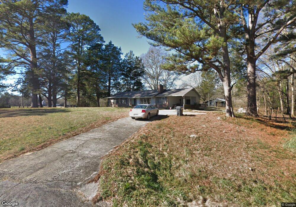
219 Martin Rd Sharpsburg, GA 30277
Estimated Value: $255,129 - $441,000
3
Beds
2
Baths
1,547
Sq Ft
$223/Sq Ft
Est. Value
About This Home
This home is located at 219 Martin Rd, Sharpsburg, GA 30277 and is currently estimated at $345,282, approximately $223 per square foot. 219 Martin Rd is a home located in Coweta County with nearby schools including Poplar Road Elementary School, East Coweta Middle School, and East Coweta High School.
Ownership History
Date
Name
Owned For
Owner Type
Purchase Details
Closed on
Aug 24, 2018
Sold by
Stanford Charles David
Bought by
Scott Robert M
Current Estimated Value
Purchase Details
Closed on
Nov 7, 2013
Sold by
Morningstar Thomas W
Bought by
Morningstar Charles David
Purchase Details
Closed on
Feb 3, 1994
Bought by
Morningstar Thomas W and Morningst Donna R
Purchase Details
Closed on
Sep 16, 1975
Bought by
Morningstar Thomas W
Create a Home Valuation Report for This Property
The Home Valuation Report is an in-depth analysis detailing your home's value as well as a comparison with similar homes in the area
Home Values in the Area
Average Home Value in this Area
Purchase History
| Date | Buyer | Sale Price | Title Company |
|---|---|---|---|
| Scott Robert M | -- | -- | |
| Morningstar Charles David | $175,000 | -- | |
| Morningstar Thomas W | $49,500 | -- | |
| Morningstar Thomas W | $49,500 | -- |
Source: Public Records
Tax History Compared to Growth
Tax History
| Year | Tax Paid | Tax Assessment Tax Assessment Total Assessment is a certain percentage of the fair market value that is determined by local assessors to be the total taxable value of land and additions on the property. | Land | Improvement |
|---|---|---|---|---|
| 2025 | $1,595 | $67,516 | $3,352 | $64,164 |
| 2024 | $1,535 | $66,136 | $2,287 | $63,849 |
| 2023 | $1,535 | $60,927 | $2,516 | $58,411 |
| 2022 | $1,114 | $53,209 | $2,401 | $50,808 |
| 2021 | $1,201 | $45,609 | $1,361 | $44,248 |
| 2020 | $1,437 | $63,807 | $19,559 | $44,248 |
| 2019 | $1,322 | $45,178 | $5,033 | $40,145 |
| 2018 | $1,325 | $45,178 | $5,033 | $40,145 |
| 2017 | $1,324 | $45,178 | $5,033 | $40,145 |
| 2016 | $1,308 | $45,178 | $5,033 | $40,145 |
| 2015 | $1,722 | $60,498 | $20,353 | $40,145 |
| 2014 | $858 | $60,498 | $20,353 | $40,145 |
Source: Public Records
Map
Nearby Homes
- 0 Cannon Rd Unit 7627017
- 0 Cannon Rd Unit 10566028
- 4083 Highway 54
- 165 Durham Estates Dr
- 65 Oakhurst Trail
- 69 Oakhurst Trail
- 49 Durham Estates Dr
- 465 Little Rd
- 215 Grey Fairs Ave
- 565 Timberbrook Dr
- 98 Ryeland Dr
- 136 Ryeland Dr
- 143 Ryeland Dr
- 0 Johnson Rd Unit LOT 4 10583889
- 0 Johnson Rd Unit LOT 3 10583885
- 0 Sid Hunter Rd Unit LOT 1
- 0 Sid Hunter Rd Unit LOT 2 10583878
- 46 Lullwater Ct
- 2812 Highway 16 E
- 83 Homesite Slick Ct