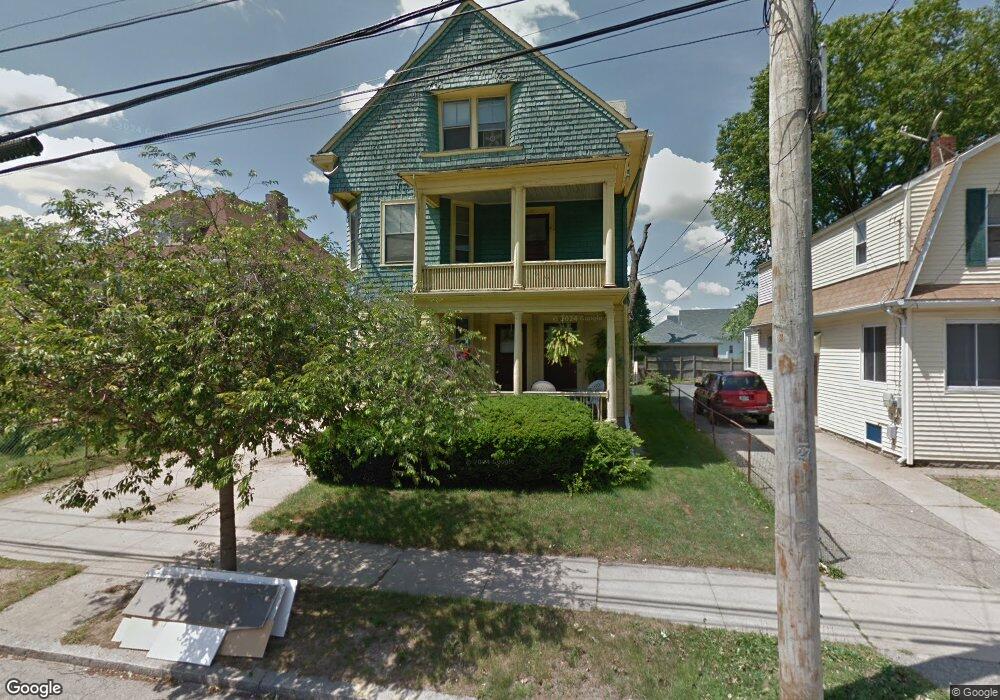
219 Melrose St Providence, RI 02907
Elmwood NeighborhoodEstimated Value: $573,000 - $603,000
5
Beds
3
Baths
2,765
Sq Ft
$212/Sq Ft
Est. Value
About This Home
This home is located at 219 Melrose St, Providence, RI 02907 and is currently estimated at $587,333, approximately $212 per square foot. 219 Melrose St is a home located in Providence County with nearby schools including Asa Messer Elementary School, Charles N. Fortes Elementary School, and Alfred Lima Sr. Elementary School.
Ownership History
Date
Name
Owned For
Owner Type
Purchase Details
Closed on
Dec 16, 2010
Sold by
Jones Joseph A
Bought by
Jones Joseph A and Young Peggy D
Current Estimated Value
Purchase Details
Closed on
Oct 17, 2007
Sold by
Jones Joseph A and Narragansett Bay Cmnty
Bought by
Narragansett Bay Cmnty
Create a Home Valuation Report for This Property
The Home Valuation Report is an in-depth analysis detailing your home's value as well as a comparison with similar homes in the area
Home Values in the Area
Average Home Value in this Area
Purchase History
| Date | Buyer | Sale Price | Title Company |
|---|---|---|---|
| Jones Joseph A | -- | -- | |
| Narragansett Bay Cmnty | $1,656 | -- |
Source: Public Records
Mortgage History
| Date | Status | Borrower | Loan Amount |
|---|---|---|---|
| Previous Owner | Narragansett Bay Cmnty | $19,600 | |
| Previous Owner | Narragansett Bay Cmnty | $10,000 |
Source: Public Records
Tax History Compared to Growth
Tax History
| Year | Tax Paid | Tax Assessment Tax Assessment Total Assessment is a certain percentage of the fair market value that is determined by local assessors to be the total taxable value of land and additions on the property. | Land | Improvement |
|---|---|---|---|---|
| 2025 | $4,821 | $638,500 | $121,500 | $517,000 |
| 2024 | $7,490 | $408,200 | $52,700 | $355,500 |
| 2023 | $7,490 | $408,200 | $52,700 | $355,500 |
| 2022 | $7,266 | $408,200 | $52,700 | $355,500 |
| 2021 | $6,511 | $265,100 | $38,600 | $226,500 |
| 2020 | $6,511 | $265,100 | $38,600 | $226,500 |
| 2019 | $6,511 | $265,100 | $38,600 | $226,500 |
| 2018 | $4,299 | $134,500 | $26,300 | $108,200 |
| 2017 | $4,299 | $134,500 | $26,300 | $108,200 |
| 2016 | $4,299 | $134,500 | $26,300 | $108,200 |
| 2015 | $2,900 | $87,600 | $32,200 | $55,400 |
| 2014 | $2,957 | $87,600 | $32,200 | $55,400 |
| 2013 | $2,504 | $74,200 | $32,200 | $42,000 |
Source: Public Records
Map
Nearby Homes
- 187 Warrington St
- 246 Sackett St
- 154 Gallatin St Unit 156
- 182 Adelaide Ave Unit 3
- 98 Sackett St
- 132 Atlantic Ave
- 76 Adelaide Ave
- 354 Adelaide Ave
- 33 Adelaide Ave
- 35 Humes St
- 8 Atlantic Ave
- 31 Burrows St
- 29 Crescent St
- 41 Rounds Ave
- 6 Warrington St
- 150 Early St
- 131 Mitchell St
- 51 Detroit Ave
- 136 Houston St
- 143 Houston St
- 225 Melrose St
- 215 Melrose St
- 195 Sackett St
- 211 Melrose St
- 222 Warrington St
- 199 Sackett St Unit 201
- 228 Warrington St
- 220 Melrose St
- 214 Melrose St
- 224 Melrose St
- 186 Sackett St
- 203 Sackett St
- 190 Sackett St
- 234 Warrington St
- 196 Sackett St
- 233 Melrose St
- 201 Melrose St
- 207 Sackett St
- 238 Warrington St
- 200 Sackett St