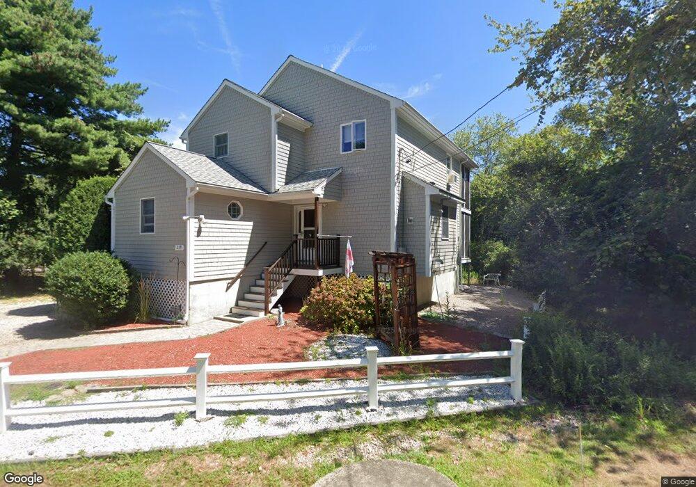
219 Middlebridge Rd Wakefield, RI 02879
Estimated Value: $669,000 - $885,000
2
Beds
2
Baths
1,741
Sq Ft
$435/Sq Ft
Est. Value
About This Home
This home is located at 219 Middlebridge Rd, Wakefield, RI 02879 and is currently estimated at $757,797, approximately $435 per square foot. 219 Middlebridge Rd is a home located in Washington County with nearby schools including South Kingstown High School, Quest Montessori School, and Monsignor Matthew Clarke Catholic Regional School.
Ownership History
Date
Name
Owned For
Owner Type
Purchase Details
Closed on
Jul 6, 2001
Sold by
Veltri Marjorie L
Bought by
Dery Leo H and Dery Alice A
Current Estimated Value
Purchase Details
Closed on
Jul 23, 1999
Sold by
Harrington David G and Harrington Donald C
Bought by
Veltri Majorie L
Create a Home Valuation Report for This Property
The Home Valuation Report is an in-depth analysis detailing your home's value as well as a comparison with similar homes in the area
Home Values in the Area
Average Home Value in this Area
Purchase History
| Date | Buyer | Sale Price | Title Company |
|---|---|---|---|
| Dery Leo H | $105,000 | -- | |
| Veltri Majorie L | $22,500 | -- |
Source: Public Records
Mortgage History
| Date | Status | Borrower | Loan Amount |
|---|---|---|---|
| Closed | Veltri Majorie L | $110,000 | |
| Closed | Veltri Majorie L | $270,000 | |
| Closed | Veltri Majorie L | $322,400 | |
| Closed | Veltri Majorie L | $200,000 |
Source: Public Records
Tax History
| Year | Tax Paid | Tax Assessment Tax Assessment Total Assessment is a certain percentage of the fair market value that is determined by local assessors to be the total taxable value of land and additions on the property. | Land | Improvement |
|---|---|---|---|---|
| 2025 | $5,347 | $598,100 | $239,400 | $358,700 |
| 2024 | $5,652 | $511,500 | $184,200 | $327,300 |
| 2023 | $5,652 | $511,500 | $184,200 | $327,300 |
| 2022 | $5,601 | $511,500 | $184,200 | $327,300 |
| 2021 | $5,786 | $400,400 | $160,100 | $240,300 |
| 2020 | $5,786 | $400,400 | $160,100 | $240,300 |
| 2019 | $5,786 | $400,400 | $160,100 | $240,300 |
| 2018 | $5,399 | $344,300 | $148,900 | $195,400 |
| 2017 | $5,271 | $344,300 | $148,900 | $195,400 |
| 2016 | $5,195 | $344,300 | $148,900 | $195,400 |
| 2015 | $5,229 | $336,900 | $145,600 | $191,300 |
| 2014 | $5,215 | $336,900 | $145,600 | $191,300 |
Source: Public Records
Map
Nearby Homes
- 19 Castle Rd
- 5 Wayland Trail
- 0 Indian Trail Trail S Unit 1389828
- 0 Indian Run Trail Unit 1403300
- 30 Crest Ave
- 727 Boston Neck Rd
- 844 Boston Neck Rd
- 63 Sassafras Trail
- 36 Sachem Rd
- 175 Bonnet Point Rd Unit B 44
- 175 Bonnet Point Rd Unit 29
- 18 Aroostook Trail
- 54 Othmar St
- 56 Wanda St
- 416 Bridgetown Rd
- 1029 Boston Neck Rd Unit 2
- 15 Jessica Ln
- 54 Isabelle Dr
- 51 Bonnet Shores Rd
- 53 Bonnet Shores Rd
- 235 Middlebridge Rd
- 201 Middlebridge Rd
- 51 Lafayette Ave
- 224 Middlebridge Rd
- 200 Middlebridge Rd
- 202 Middlebridge Rd
- 19 Lafayette Ave
- 4 Maple St Unit A
- 55 Lafayette Ave
- 44 Lafayette Ave
- 56 Grant Ave
- 234 Middlebridge Rd
- 13 Lafayette Ave
- 240 Middlebridge Rd
- 1 Maple St
- 9 Maple St
- 7 Lafayette Ave
- 188 Middlebridge Rd
- 64 Grant Ave
- 15 Maple St
Your Personal Tour Guide
Ask me questions while you tour the home.