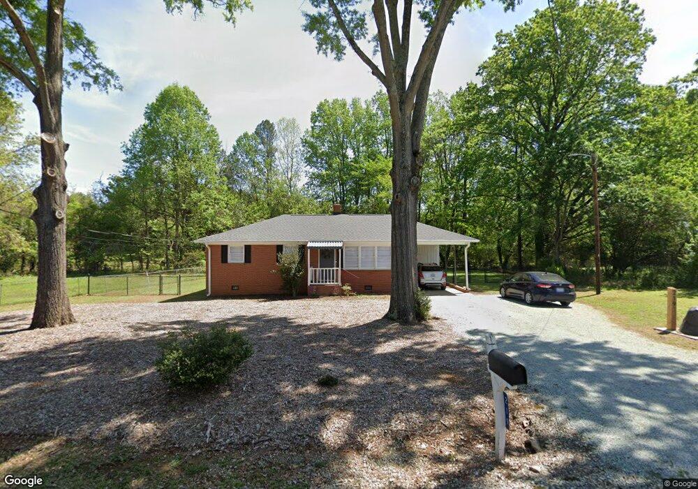
219 Parthenia Dr Durham, NC 27705
West Durham NeighborhoodEstimated Value: $227,000 - $337,000
3
Beds
1
Bath
1,014
Sq Ft
$277/Sq Ft
Est. Value
About This Home
This home is located at 219 Parthenia Dr, Durham, NC 27705 and is currently estimated at $280,444, approximately $276 per square foot. 219 Parthenia Dr is a home located in Durham County with nearby schools including Morehead Montessori, Brogden Middle, and Riverside High School.
Ownership History
Date
Name
Owned For
Owner Type
Purchase Details
Closed on
Nov 1, 2010
Sold by
Macgregor Justin C and Macgregor Emily R
Bought by
Trustees Of Mcmannen United Methodist Ch
Current Estimated Value
Purchase Details
Closed on
Apr 27, 2009
Sold by
Macgregor Daryl T and Macgregor Rob Roy
Bought by
Macgregor Justin Christopher and Macgregor Emily Ryan
Create a Home Valuation Report for This Property
The Home Valuation Report is an in-depth analysis detailing your home's value as well as a comparison with similar homes in the area
Home Values in the Area
Average Home Value in this Area
Purchase History
| Date | Buyer | Sale Price | Title Company |
|---|---|---|---|
| Trustees Of Mcmannen United Methodist Ch | $117,500 | None Available | |
| Macgregor Justin Christopher | -- | None Available | |
| Macgregor Daryl T | -- | None Available |
Source: Public Records
Tax History Compared to Growth
Tax History
| Year | Tax Paid | Tax Assessment Tax Assessment Total Assessment is a certain percentage of the fair market value that is determined by local assessors to be the total taxable value of land and additions on the property. | Land | Improvement |
|---|---|---|---|---|
| 2025 | -- | $310,592 | $159,600 | $150,992 |
| 2024 | -- | $170,582 | $84,200 | $86,382 |
| 2023 | $0 | $170,582 | $84,200 | $86,382 |
| 2022 | $0 | $170,582 | $84,200 | $86,382 |
| 2021 | $0 | $170,582 | $84,200 | $86,382 |
| 2020 | $2,122 | $170,582 | $84,200 | $86,382 |
| 2019 | $2,122 | $170,582 | $84,200 | $86,382 |
| 2018 | $1,651 | $121,688 | $52,625 | $69,063 |
| 2017 | $0 | $121,688 | $52,625 | $69,063 |
| 2016 | -- | $121,688 | $52,625 | $69,063 |
| 2015 | -- | $85,456 | $27,751 | $57,705 |
| 2014 | -- | $85,456 | $27,751 | $57,705 |
Source: Public Records
Map
Nearby Homes
- 28 Prestwick Place
- 13 Providence Ct
- 37 Georgetown Ct
- 210 Silas St
- 108 Panamint Dr
- 1229 Opal Ln Unit 84
- 74 Forest Oaks Dr
- 123 Forest Oaks Dr
- 82 Forest Oaks Dr
- 2100 Skipping Stone Dr
- 1100 Balsawood Dr
- 300 Vincent Ave
- 416 Morreene Rd
- 3 Greenway Cir
- Collins Plan at Stonewood Estates - Legacy
- Fisher Plan at Stonewood Estates - Landmark
- Winston Plan at Stonewood Estates - Landmark
- Mitchell Plan at Stonewood Estates - Landmark
- Hatteras Plan at Stonewood Estates - Landmark
- Elizabeth Plan at Stonewood Estates - Legacy