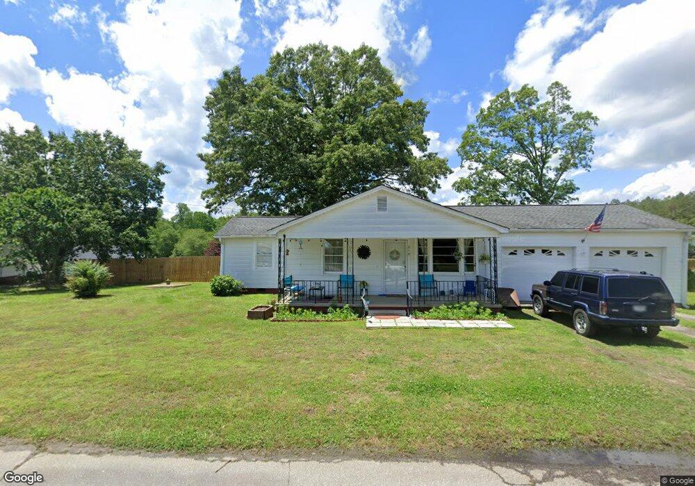
219 Poinsett Cir Easley, SC 29640
Estimated Value: $156,408 - $191,000
2
Beds
1
Bath
1,116
Sq Ft
$156/Sq Ft
Est. Value
About This Home
This home is located at 219 Poinsett Cir, Easley, SC 29640 and is currently estimated at $173,852, approximately $155 per square foot. 219 Poinsett Cir is a home located in Pickens County with nearby schools including Pickens Elementary School, Pickens Middle School, and Pickens High School.
Ownership History
Date
Name
Owned For
Owner Type
Purchase Details
Closed on
Jul 15, 2024
Sold by
Kean Autumn Leanna and Cullen Autumn
Bought by
Kean Autumn Leanna and Kean Tyler Aaron
Current Estimated Value
Home Financials for this Owner
Home Financials are based on the most recent Mortgage that was taken out on this home.
Original Mortgage
$79,000
Outstanding Balance
$78,056
Interest Rate
6.99%
Mortgage Type
New Conventional
Estimated Equity
$95,796
Purchase Details
Closed on
May 24, 2019
Sold by
Crumpton Dennis R and Crumpton Charles Allen
Bought by
Cullen Autumn
Purchase Details
Closed on
Sep 18, 2004
Sold by
Crumpton Bernice P
Bought by
Crumpton Bernice P
Create a Home Valuation Report for This Property
The Home Valuation Report is an in-depth analysis detailing your home's value as well as a comparison with similar homes in the area
Home Values in the Area
Average Home Value in this Area
Purchase History
| Date | Buyer | Sale Price | Title Company |
|---|---|---|---|
| Kean Autumn Leanna | -- | None Listed On Document | |
| Cullen Autumn | $87,000 | None Available | |
| Crumpton Bernice P | -- | None Available |
Source: Public Records
Mortgage History
| Date | Status | Borrower | Loan Amount |
|---|---|---|---|
| Open | Kean Autumn Leanna | $79,000 |
Source: Public Records
Tax History Compared to Growth
Tax History
| Year | Tax Paid | Tax Assessment Tax Assessment Total Assessment is a certain percentage of the fair market value that is determined by local assessors to be the total taxable value of land and additions on the property. | Land | Improvement |
|---|---|---|---|---|
| 2024 | $1,347 | $3,480 | $560 | $2,920 |
| 2023 | $418 | $3,480 | $560 | $2,920 |
| 2022 | $420 | $3,480 | $560 | $2,920 |
| 2021 | $436 | $3,480 | $560 | $2,920 |
| 2020 | $496 | $3,480 | $560 | $2,920 |
| 2019 | $437 | $2,780 | $560 | $2,220 |
| 2018 | $957 | $3,700 | $720 | $2,980 |
| 2017 | $180 | $3,700 | $720 | $2,980 |
| 2015 | $580 | $2,470 | $0 | $0 |
| 2008 | -- | $2,460 | $440 | $2,020 |
Source: Public Records
Map
Nearby Homes
- 316 Church Rd
- 102 Westwood Cir
- 306 Rice Rd
- 2156 Gentry Memorial Hwy
- 2224 Gentry Memorial Hwy
- 122 Harvest Dr
- 126 Edinburg Rd
- 281 Loch Lomond Dr
- 107 Bentwood Ln
- 145 Margaret St
- 105 Bentwood Ln
- 0 Griffin Mill Rd Unit Tract C
- 0 Griffin Mill Rd Unit 20294126
- 326 Chesapeake Trail
- 409 Mulberry Rd
- 407 Mulberry Rd
- 1121 Ireland Rd
- 500 Griffin Mill Rd
- 1057 Country Club Rd
- 1057 Country Club Rd
- 808 Elljean Rd
- 800 Elljean Rd
- 119 Poinsett Cir
- 205 Poinsett Cir
- 198 Poinsett Cir
- 722 Elljean Rd
- 116 Poinsett Cir
- 194 Poinsett Cir
- 167 Poinsett Cir
- 715 Elljean Rd
- 702 Elljean Rd
- 186 Poinsett Cir
- 132 Poinsett Cir
- 182 Poinsett Cir
- 164 Poinsett Cir
- 226 Bagwell St
- 237 Bagwell St
- 629 Elljean Rd
- 622 Elljean Rd
- 223 Bagwell St