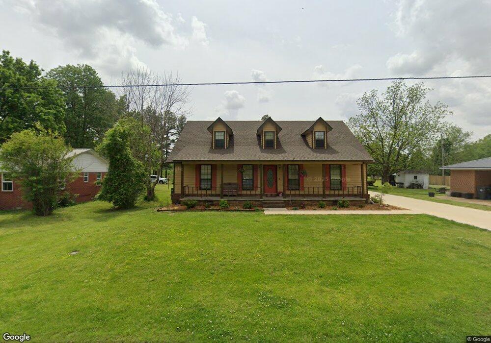
219 Rebecca Ln Walnut Ridge, AR 72476
Estimated Value: $191,553 - $290,000
--
Bed
2
Baths
2,392
Sq Ft
$98/Sq Ft
Est. Value
About This Home
This home is located at 219 Rebecca Ln, Walnut Ridge, AR 72476 and is currently estimated at $235,388, approximately $98 per square foot. 219 Rebecca Ln is a home located in Lawrence County with nearby schools including Walnut Ridge Elementary School and Walnut Ridge High School.
Ownership History
Date
Name
Owned For
Owner Type
Purchase Details
Closed on
Dec 14, 2021
Sold by
Fitzgerald Charles L and Fitzgerald Amy C
Bought by
Fitzgerald Charles L and Fitzgerald Amy C
Current Estimated Value
Purchase Details
Closed on
Jul 13, 2007
Sold by
Wallin Freddie Michael and Wallin Karen
Bought by
Fitzerald Charles L and Fitzerald Amy C
Home Financials for this Owner
Home Financials are based on the most recent Mortgage that was taken out on this home.
Original Mortgage
$120,000
Interest Rate
6.71%
Mortgage Type
New Conventional
Purchase Details
Closed on
Mar 24, 1994
Bought by
Wallin Karen and Kathy Mehringer
Purchase Details
Closed on
Jan 2, 1990
Bought by
Hawn James G and Hawn Nellie D
Create a Home Valuation Report for This Property
The Home Valuation Report is an in-depth analysis detailing your home's value as well as a comparison with similar homes in the area
Home Values in the Area
Average Home Value in this Area
Purchase History
| Date | Buyer | Sale Price | Title Company |
|---|---|---|---|
| Fitzgerald Charles L | -- | None Available | |
| Fitzgerald Charles L | -- | None Listed On Document | |
| Fitzerald Charles L | -- | None Avelable | |
| Wallin Karen | -- | -- | |
| Hawn James G | $8,000 | -- |
Source: Public Records
Mortgage History
| Date | Status | Borrower | Loan Amount |
|---|---|---|---|
| Previous Owner | Fitzerald Charles L | $120,000 |
Source: Public Records
Tax History Compared to Growth
Tax History
| Year | Tax Paid | Tax Assessment Tax Assessment Total Assessment is a certain percentage of the fair market value that is determined by local assessors to be the total taxable value of land and additions on the property. | Land | Improvement |
|---|---|---|---|---|
| 2024 | $716 | $34,397 | $1,800 | $32,597 |
| 2023 | $736 | $34,397 | $1,800 | $32,597 |
| 2022 | $731 | $24,160 | $1,800 | $22,360 |
| 2021 | $731 | $24,160 | $1,800 | $22,360 |
| 2020 | $731 | $24,160 | $1,800 | $22,360 |
| 2019 | $731 | $24,160 | $1,800 | $22,360 |
| 2018 | $731 | $24,160 | $1,800 | $22,360 |
| 2017 | $603 | $22,480 | $1,350 | $21,130 |
| 2016 | $603 | $22,480 | $1,350 | $21,130 |
| 2015 | $603 | $22,480 | $1,350 | $21,130 |
| 2014 | $603 | $22,480 | $1,350 | $21,130 |
Source: Public Records
Map
Nearby Homes
- 611 Pocahontas Rd
- 100 Charleston Dr
- 511 Pocahontas Rd
- 1 Acre Hwy 67 B
- 1 Acre Hwy 67b
- 107 NW Inman Dr
- 4.16 ac (+/-) 26-17-01e Highway 67
- 620 W Main St
- 1303 Magnolia Ave
- 823 NW 5th St
- 1402 Azalea Ave
- 906 NW 6th St
- 601 Stewart St
- 1409 Magnolia Ave
- 1080 Cr 438
- 420 NW 3rd St
- 202 W Hazel St
- 1309 Holly St
- 317 W Vine St
- 305 SW 3rd St