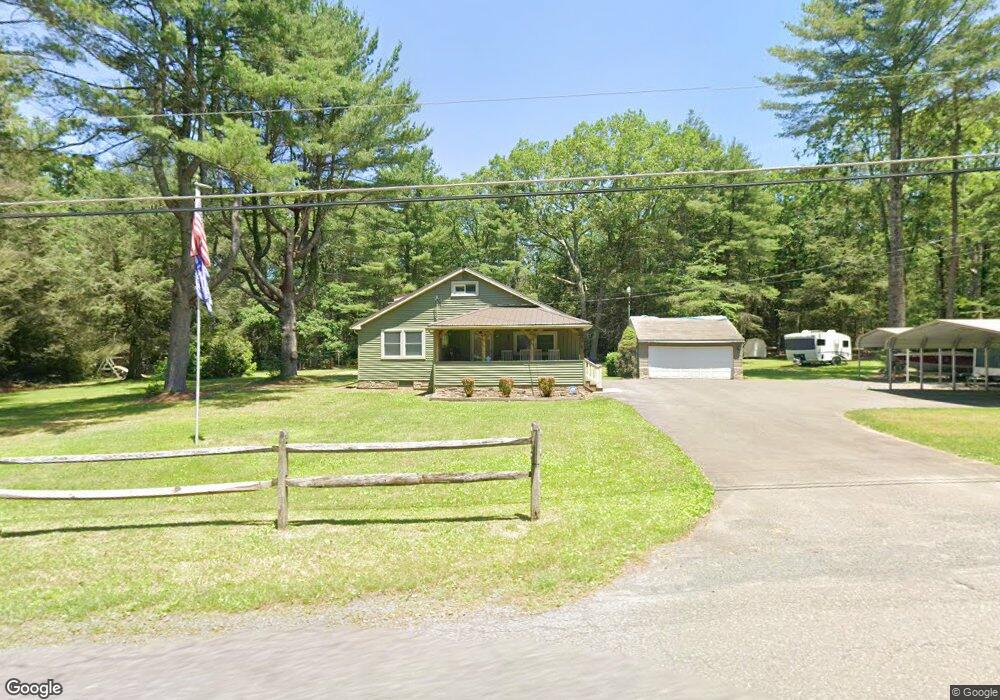
219 Smith Rd Jim Thorpe, PA 18229
Estimated Value: $154,432 - $444,000
4
Beds
1
Bath
1,420
Sq Ft
$176/Sq Ft
Est. Value
About This Home
This home is located at 219 Smith Rd, Jim Thorpe, PA 18229 and is currently estimated at $250,608, approximately $176 per square foot. 219 Smith Rd is a home located in Carbon County with nearby schools including Jim Thorpe Area High School.
Ownership History
Date
Name
Owned For
Owner Type
Purchase Details
Closed on
Dec 19, 2023
Sold by
Topieniak Steven and Topieniak Amber K
Bought by
Titan Enterprises Trust and Topieniak
Current Estimated Value
Purchase Details
Closed on
Sep 22, 2020
Sold by
Topieniak David and Topieniak Steven
Bought by
Topieniak Steven and Topieniak Amber K
Create a Home Valuation Report for This Property
The Home Valuation Report is an in-depth analysis detailing your home's value as well as a comparison with similar homes in the area
Home Values in the Area
Average Home Value in this Area
Purchase History
| Date | Buyer | Sale Price | Title Company |
|---|---|---|---|
| Titan Enterprises Trust | -- | None Listed On Document | |
| Topieniak Steven | -- | None Available |
Source: Public Records
Mortgage History
| Date | Status | Borrower | Loan Amount |
|---|---|---|---|
| Previous Owner | Topieniak Steven | $106,100 | |
| Previous Owner | Topieniak Steven | $19,000 | |
| Previous Owner | Topieniak Amber K | $159,200 | |
| Previous Owner | Topieniak Steven | $125,000 | |
| Previous Owner | Topieniak David | $46,000 | |
| Previous Owner | Topieniak David | $140,125 |
Source: Public Records
Tax History Compared to Growth
Tax History
| Year | Tax Paid | Tax Assessment Tax Assessment Total Assessment is a certain percentage of the fair market value that is determined by local assessors to be the total taxable value of land and additions on the property. | Land | Improvement |
|---|---|---|---|---|
| 2025 | $1,806 | $29,350 | $8,250 | $21,100 |
| 2024 | $1,718 | $29,350 | $8,250 | $21,100 |
| 2023 | $1,696 | $29,350 | $8,250 | $21,100 |
| 2022 | $1,696 | $29,350 | $8,250 | $21,100 |
| 2021 | $1,696 | $29,350 | $8,250 | $21,100 |
| 2020 | $1,696 | $29,350 | $8,250 | $21,100 |
| 2019 | $1,637 | $29,350 | $8,250 | $21,100 |
| 2018 | $1,637 | $29,350 | $8,250 | $21,100 |
| 2017 | $1,637 | $29,350 | $8,250 | $21,100 |
| 2016 | -- | $29,350 | $8,250 | $21,100 |
| 2015 | -- | $29,350 | $8,250 | $21,100 |
| 2014 | -- | $29,350 | $8,250 | $21,100 |
Source: Public Records
Map
Nearby Homes
- 66 Hummingbird Dr
- 169 Yellow Run Rd
- 0 Yellow Run Rd Unit 752474
- 0 Lot J769 Yellow Run Rd
- J752 Yellow Run Rd
- 1733 State Route 903
- 0 Poplar Ln Unit PM-135166
- 752 Yellow Run Rd
- 748 Yellow Run Rd
- 731 Yellow Run Rd
- A310 Poplar Dr
- A309 Poplar Dr
- 4 Redwood Dr
- A489 Redwood Dr
- 489 Redwood Dr
- Lot I731 Yellow Run Rd
- Lot 12 Rhododendron Rd
- H570 Cross Run Road & Engler Ln
- 0 Lot A12 Rhododendron Rd
- H593 Engler Ln
- 223 Smith Rd
- 216 Smith Rd
- 228 Smith Rd
- 42 White Pine Rd
- 34 White Pine Rd
- 48 White Pine Rd
- 203 Smith Rd
- 30-31 Oak St
- A7-02 Smith Rd
- A7.02 Smith Rd
- 17 Smith Cir
- 196 Smith Rd
- 0 White Pine Driftwood Rd
- 241 Smith Rd
- A48 White Pine & Red Oak Dr
- 0 A48 White Pine & Red Oak Dr Unit PM-91160
- 64 White Pine Rd
- 65 White Pine Rd
- 0 White Pine Rd
- 242 Smith Rd