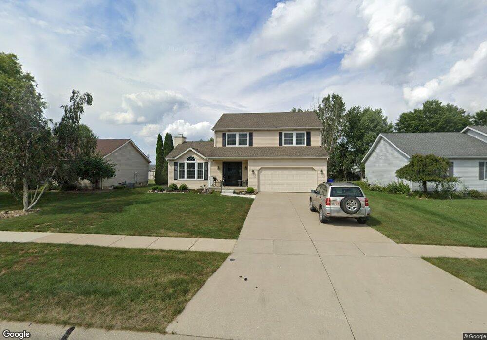
219 Taylor Blvd Lagrange, OH 44050
Estimated Value: $372,275 - $449,000
3
Beds
3
Baths
2,059
Sq Ft
$204/Sq Ft
Est. Value
About This Home
This home is located at 219 Taylor Blvd, Lagrange, OH 44050 and is currently estimated at $420,819, approximately $204 per square foot. 219 Taylor Blvd is a home located in Lorain County with nearby schools including Keystone Elementary School, Keystone Middle School, and Keystone High School.
Ownership History
Date
Name
Owned For
Owner Type
Purchase Details
Closed on
Oct 24, 2024
Sold by
Myhrman Traci L
Bought by
Traci L Myhrman Trust and Myhrman
Current Estimated Value
Purchase Details
Closed on
Sep 16, 2013
Sold by
Walker Richard G
Bought by
Myhrman Traci L
Home Financials for this Owner
Home Financials are based on the most recent Mortgage that was taken out on this home.
Original Mortgage
$146,625
Interest Rate
4.38%
Mortgage Type
Future Advance Clause Open End Mortgage
Purchase Details
Closed on
Mar 28, 2012
Sold by
Walker Stacy A and Dennis Stacy A
Bought by
Walker Richard G
Home Financials for this Owner
Home Financials are based on the most recent Mortgage that was taken out on this home.
Original Mortgage
$116,500
Interest Rate
3.9%
Mortgage Type
New Conventional
Purchase Details
Closed on
Oct 7, 1999
Sold by
Feeney Dale M and Feeney Nancy L
Bought by
Walker Richard G and Walker Stacey A
Home Financials for this Owner
Home Financials are based on the most recent Mortgage that was taken out on this home.
Original Mortgage
$134,000
Interest Rate
7.83%
Create a Home Valuation Report for This Property
The Home Valuation Report is an in-depth analysis detailing your home's value as well as a comparison with similar homes in the area
Home Values in the Area
Average Home Value in this Area
Purchase History
| Date | Buyer | Sale Price | Title Company |
|---|---|---|---|
| Traci L Myhrman Trust | -- | None Listed On Document | |
| Myhrman Traci L | $172,500 | Old Republic National Title | |
| Walker Richard G | -- | Lawyers Title Co | |
| Walker Richard G | $167,500 | Midland Title |
Source: Public Records
Mortgage History
| Date | Status | Borrower | Loan Amount |
|---|---|---|---|
| Previous Owner | Myhrman Traci L | $146,625 | |
| Previous Owner | Walker Richard G | $116,500 | |
| Previous Owner | Walker Richard G | $134,000 |
Source: Public Records
Tax History
| Year | Tax Paid | Tax Assessment Tax Assessment Total Assessment is a certain percentage of the fair market value that is determined by local assessors to be the total taxable value of land and additions on the property. | Land | Improvement |
|---|---|---|---|---|
| 2024 | $4,636 | $109,354 | $13,300 | $96,054 |
| 2023 | $3,667 | $72,226 | $12,226 | $60,001 |
| 2022 | $3,643 | $72,226 | $12,226 | $60,001 |
| 2021 | $3,644 | $72,226 | $12,226 | $60,001 |
| 2020 | $3,559 | $62,860 | $10,640 | $52,220 |
| 2019 | $3,539 | $62,860 | $10,640 | $52,220 |
| 2018 | $3,415 | $62,860 | $10,640 | $52,220 |
| 2017 | $3,514 | $60,570 | $9,380 | $51,190 |
| 2016 | $3,491 | $60,570 | $9,380 | $51,190 |
| 2015 | $3,486 | $60,570 | $9,380 | $51,190 |
| 2014 | $3,031 | $59,680 | $9,240 | $50,440 |
| 2013 | $2,904 | $58,950 | $9,240 | $49,710 |
Source: Public Records
Map
Nearby Homes
- 516 Appomattox Ct
- 548 William St
- 317 Church St
- 567 Vicksburg Ct
- 0 Dill Ct Unit 5072837
- 808 Buckingham Dr
- 800 Buckingham Dr
- 340 Granger Dr
- 801 Willich Ct
- 829 Robinson Dr
- 305 W Main St
- 110 Railroad St
- 40260 Whitney Rd
- 40175 Banks Rd
- 42113 Meadow Ln
- 40163 Banks Rd
- 1033 Parsons Rd Unit 11
- 704 Black Bear Run
- 510 Arabian Ct
- 476 Stallion Ct
- 223 Taylor Blvd
- 215 Taylor Blvd
- 227 Taylor Blvd
- 211 Taylor Blvd
- 218 Hendrix Blvd
- 214 Hendrix Blvd
- 222 Hendrix Blvd
- 231 Taylor Blvd
- 207 Taylor Blvd
- 210 Hendrix Blvd
- 220 Taylor Blvd
- 216 Taylor Blvd
- 224 Taylor Blvd
- 226 Hendrix Blvd
- 212 Taylor Blvd
- 228 Taylor Blvd
- 206 Hendrix Blvd
- 203 Taylor Blvd
- 503 Rundle St
- 208 Taylor Blvd
Your Personal Tour Guide
Ask me questions while you tour the home.