Estimated Value: $148,000 - $228,000
3
Beds
2
Baths
1,500
Sq Ft
$132/Sq Ft
Est. Value
About This Home
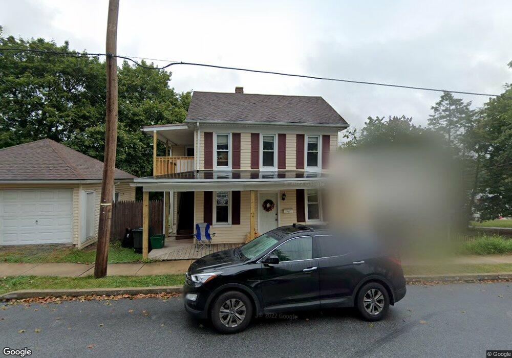
This home is located at 219 W Broad St, Yoe, PA 17313 and is currently estimated at $198,345, approximately $132 per square foot. 219 W Broad St is a home located in York County with nearby schools including Ore Valley Elementary School, Dallastown Area Middle School, and Dallastown Area High School.
Ownership History
Date
Name
Owned For
Owner Type
Purchase Details
Closed on
Oct 24, 2008
Sold by
Jp Morgan Chase Bank
Bought by
Thompson Eric A
Current Estimated Value
Home Financials for this Owner
Home Financials are based on the most recent Mortgage that was taken out on this home.
Original Mortgage
$101,449
Outstanding Balance
$66,482
Interest Rate
6.13%
Mortgage Type
FHA
Estimated Equity
$131,863
Purchase Details
Closed on
Aug 5, 2008
Sold by
Tweedy Peri and Tweedy Richard E
Bought by
Jp Morgan Chase Bank
Purchase Details
Closed on
Dec 22, 1998
Sold by
219 West Broad Street Land Trust
Bought by
Tweedy Richard E
Home Financials for this Owner
Home Financials are based on the most recent Mortgage that was taken out on this home.
Original Mortgage
$87,750
Interest Rate
6.89%
Purchase Details
Closed on
Aug 31, 1998
Sold by
Abendschoen Thomas J and Abendschoen Edward J
Bought by
219 West Broad Street Land Trust
Create a Home Valuation Report for This Property
The Home Valuation Report is an in-depth analysis detailing your home's value as well as a comparison with similar homes in the area
Home Values in the Area
Average Home Value in this Area
Purchase History
| Date | Buyer | Sale Price | Title Company |
|---|---|---|---|
| Thompson Eric A | $102,000 | None Available | |
| Jp Morgan Chase Bank | $2,262 | None Available | |
| Tweedy Richard E | $97,500 | -- | |
| 219 West Broad Street Land Trust | $37,000 | -- |
Source: Public Records
Mortgage History
| Date | Status | Borrower | Loan Amount |
|---|---|---|---|
| Open | Thompson Eric A | $101,449 | |
| Previous Owner | Tweedy Richard E | $87,750 |
Source: Public Records
Tax History Compared to Growth
Tax History
| Year | Tax Paid | Tax Assessment Tax Assessment Total Assessment is a certain percentage of the fair market value that is determined by local assessors to be the total taxable value of land and additions on the property. | Land | Improvement |
|---|---|---|---|---|
| 2025 | $3,356 | $89,510 | $25,570 | $63,940 |
| 2024 | $3,271 | $89,510 | $25,570 | $63,940 |
| 2023 | $3,271 | $89,510 | $25,570 | $63,940 |
| 2022 | $3,172 | $89,510 | $25,570 | $63,940 |
| 2021 | $3,085 | $89,510 | $25,570 | $63,940 |
| 2020 | $3,085 | $89,510 | $25,570 | $63,940 |
| 2019 | $3,031 | $89,510 | $25,570 | $63,940 |
| 2018 | $3,031 | $89,510 | $25,570 | $63,940 |
| 2017 | $2,881 | $89,510 | $25,570 | $63,940 |
| 2016 | $0 | $89,510 | $25,570 | $63,940 |
| 2015 | -- | $89,510 | $25,570 | $63,940 |
| 2014 | -- | $89,510 | $25,570 | $63,940 |
Source: Public Records
Map
Nearby Homes
- 74 S Main St
- 774 Blossom Hill Ln
- 27 Steeple Ave
- 246 Hudson Blvd
- 234 Hudson Blvd
- 732 Blossom Hill Ln
- 6 Hudson Blvd
- 350 Avon Dr Unit 270
- 362 Avon Dr Unit 276
- 376 Avon Dr Unit 283
- 433 Bradford Dr Unit 188
- 435 Bradford Dr Unit 187
- 437 Bradford Dr Unit 186
- 439 Bradford Dr Unit 185
- 443 Bradford Dr Unit 183
- 355 W Main St
- 0 S Franklin St
- 428 W Main St
- 0 Chapel Church Rd
- 64 S Pleasant Ave