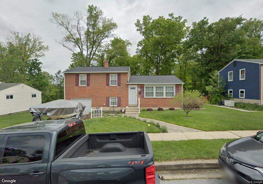
219 Worthmont Rd Catonsville, MD 21228
Estimated Value: $456,000 - $501,000
--
Bed
1
Bath
1,852
Sq Ft
$257/Sq Ft
Est. Value
About This Home
This home is located at 219 Worthmont Rd, Catonsville, MD 21228 and is currently estimated at $475,679, approximately $256 per square foot. 219 Worthmont Rd is a home located in Baltimore County with nearby schools including Westchester Elementary School, Catonsville Middle School, and Catonsville High School.
Ownership History
Date
Name
Owned For
Owner Type
Purchase Details
Closed on
Feb 28, 2003
Sold by
Secretary Of Housing
Bought by
Hall Michael C and Hall Diana L
Current Estimated Value
Purchase Details
Closed on
Oct 9, 2002
Sold by
Johnson Ronald Levurse
Bought by
Secretary Of Housing
Purchase Details
Closed on
Feb 29, 2000
Sold by
Secretary Of Housing
Bought by
Johnson Ronald Levurse
Purchase Details
Closed on
May 25, 1999
Sold by
Carroll Raymond M
Bought by
Secretary Of Housing
Create a Home Valuation Report for This Property
The Home Valuation Report is an in-depth analysis detailing your home's value as well as a comparison with similar homes in the area
Home Values in the Area
Average Home Value in this Area
Purchase History
| Date | Buyer | Sale Price | Title Company |
|---|---|---|---|
| Hall Michael C | $190,000 | -- | |
| Secretary Of Housing | $128,000 | -- | |
| Johnson Ronald Levurse | $123,200 | -- | |
| Secretary Of Housing | $130,000 | -- |
Source: Public Records
Tax History Compared to Growth
Tax History
| Year | Tax Paid | Tax Assessment Tax Assessment Total Assessment is a certain percentage of the fair market value that is determined by local assessors to be the total taxable value of land and additions on the property. | Land | Improvement |
|---|---|---|---|---|
| 2025 | $4,570 | $341,433 | -- | -- |
| 2024 | $4,570 | $321,000 | $106,200 | $214,800 |
| 2023 | $2,233 | $307,200 | $0 | $0 |
| 2022 | $4,249 | $293,400 | $0 | $0 |
| 2021 | $4,037 | $279,600 | $106,200 | $173,400 |
| 2020 | $4,037 | $275,267 | $0 | $0 |
| 2019 | $3,814 | $270,933 | $0 | $0 |
| 2018 | $3,657 | $266,600 | $95,700 | $170,900 |
| 2017 | $3,409 | $254,933 | $0 | $0 |
| 2016 | $2,876 | $243,267 | $0 | $0 |
| 2015 | $2,876 | $231,600 | $0 | $0 |
| 2014 | $2,876 | $231,600 | $0 | $0 |
Source: Public Records
Map
Nearby Homes
- 311 Radstock Rd
- 105 Oella Ave
- 302 Wessling Cir
- 2310 Rockwell Ave
- 2305 Rockwell Ave
- 2110 Edmondson Ave
- 231 Gralan Rd
- 627 Meyers Dr
- 627 Meyers Dr Unit PARCEL 108
- 2208 W Geipe Rd
- 2621 Westchester Ave
- 19 Clay Lodge Ln Unit 104
- 720 Mary Jo Way
- 11 Clay Lodge Ln Unit 204
- 1900 Lismore Ln
- 3 Rumford Dr Unit 202
- 2308 Quilting Bee Rd
- 1100 Lisadale Cir Unit 1A
- 8369 Governor Grayson Way
- 8 Seminole Ave
- 217 Worthmont Rd
- 221 Worthmont Rd
- 215 Worthmont Rd
- 223 Worthmont Rd
- 214 Worthmont Rd
- 212 Worthmont Rd
- 216 Worthmont Rd
- 210 Worthmont Rd
- 213 Worthmont Rd
- 225 Worthmont Rd
- 218 Worthmont Rd
- 208 Worthmont Rd
- 215 Radstock Rd
- 220 Worthmont Rd
- 211 Worthmont Rd
- 227 Worthmont Rd
- 2300 Whitby Ct
- 217 Radstock Rd
- 213 Radstock Rd
- 206 Worthmont Rd