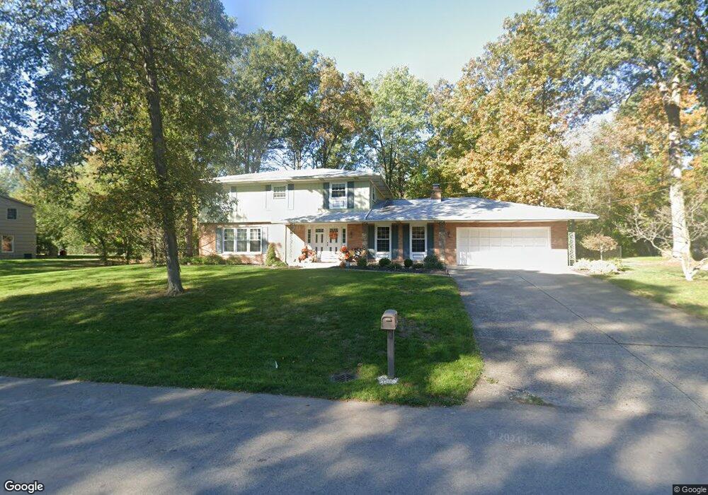
2190 High Ridge Rd Lima, OH 45805
Estimated Value: $296,000 - $340,000
4
Beds
3
Baths
2,276
Sq Ft
$142/Sq Ft
Est. Value
About This Home
This home is located at 2190 High Ridge Rd, Lima, OH 45805 and is currently estimated at $323,709, approximately $142 per square foot. 2190 High Ridge Rd is a home located in Allen County with nearby schools including Maplewood Elementary School, Elmwood Elementary School, and Shawnee Middle School.
Ownership History
Date
Name
Owned For
Owner Type
Purchase Details
Closed on
Feb 28, 2019
Sold by
Connaughton Kevin A
Bought by
Connaughton Virginia M and Cable Virginia M
Current Estimated Value
Purchase Details
Closed on
Sep 20, 2017
Sold by
Cable Elizabeth Marion
Bought by
Connaughton Virginia M and Cable Ii Chester M
Purchase Details
Closed on
Sep 5, 2017
Sold by
Estate Of Joan Marie Cable
Bought by
Cable Elizabeth Marion and Connaughton Virginia M
Purchase Details
Closed on
Jan 6, 1989
Bought by
Cable Joan M
Create a Home Valuation Report for This Property
The Home Valuation Report is an in-depth analysis detailing your home's value as well as a comparison with similar homes in the area
Home Values in the Area
Average Home Value in this Area
Purchase History
| Date | Buyer | Sale Price | Title Company |
|---|---|---|---|
| Connaughton Virginia M | -- | None Available | |
| Connaughton Virginia M | $70,000 | None Available | |
| Cable Elizabeth Marion | -- | None Available | |
| Cable Joan M | -- | -- |
Source: Public Records
Tax History Compared to Growth
Tax History
| Year | Tax Paid | Tax Assessment Tax Assessment Total Assessment is a certain percentage of the fair market value that is determined by local assessors to be the total taxable value of land and additions on the property. | Land | Improvement |
|---|---|---|---|---|
| 2024 | $4,111 | $81,690 | $17,360 | $64,330 |
| 2023 | $3,824 | $66,400 | $14,110 | $52,290 |
| 2022 | $3,830 | $66,400 | $14,110 | $52,290 |
| 2021 | $3,848 | $66,400 | $14,110 | $52,290 |
| 2020 | $2,787 | $55,830 | $13,370 | $42,460 |
| 2019 | $2,787 | $55,830 | $13,370 | $42,460 |
| 2018 | $2,651 | $55,830 | $13,370 | $42,460 |
| 2017 | $2,499 | $50,300 | $13,370 | $36,930 |
| 2016 | $2,478 | $50,300 | $13,370 | $36,930 |
| 2015 | $2,521 | $50,300 | $13,370 | $36,930 |
| 2014 | $2,521 | $50,580 | $12,850 | $37,730 |
| 2013 | $2,473 | $50,580 | $12,850 | $37,730 |
Source: Public Records
Map
Nearby Homes
- 3410 Greens Rd
- 115 Lanes End
- 2320 London Dr
- 1624 Pro Dr
- 0 Colonial Ln
- 3220 Fort Amanda Rd
- 2632 Alexandria Dr
- 3128 Clifford Dr
- 1446 Adak Ave
- 1453 W Shore Dr
- 1424 Loch Loman Way
- 1911 Wonderlick Rd
- 3031 Yoakam Rd
- 4211 Fort Amanda Rd
- 1440 Riverview Dr
- 2227 Seneca Dr
- 0 Zurmehly Rd
- 1408 Winghaven Dr
- 3390 Spencerville Rd
- 4039 Magnolia