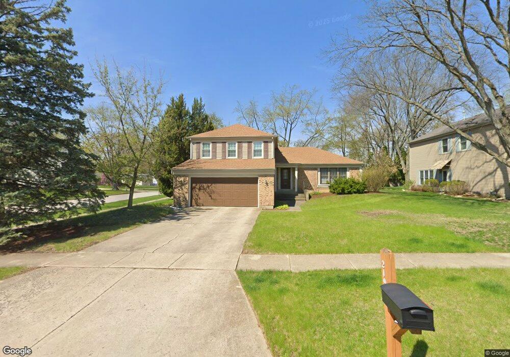
2190 Langford Ln Wheaton, IL 60189
Estimated Value: $485,349 - $577,000
4
Beds
3
Baths
2,239
Sq Ft
$238/Sq Ft
Est. Value
About This Home
This home is located at 2190 Langford Ln, Wheaton, IL 60189 and is currently estimated at $533,087, approximately $238 per square foot. 2190 Langford Ln is a home located in DuPage County with nearby schools including Arbor View Elementary School, Glen Crest Middle School, and Glenbard South High School.
Ownership History
Date
Name
Owned For
Owner Type
Purchase Details
Closed on
Sep 15, 2000
Sold by
Swindle George Frost and Swindle Patricia Anne
Bought by
Ballesteros Nestor A
Current Estimated Value
Home Financials for this Owner
Home Financials are based on the most recent Mortgage that was taken out on this home.
Original Mortgage
$218,250
Interest Rate
8.05%
Create a Home Valuation Report for This Property
The Home Valuation Report is an in-depth analysis detailing your home's value as well as a comparison with similar homes in the area
Home Values in the Area
Average Home Value in this Area
Purchase History
| Date | Buyer | Sale Price | Title Company |
|---|---|---|---|
| Ballesteros Nestor A | $242,500 | -- |
Source: Public Records
Mortgage History
| Date | Status | Borrower | Loan Amount |
|---|---|---|---|
| Closed | Ballesteros Nestor A | $218,250 |
Source: Public Records
Tax History
| Year | Tax Paid | Tax Assessment Tax Assessment Total Assessment is a certain percentage of the fair market value that is determined by local assessors to be the total taxable value of land and additions on the property. | Land | Improvement |
|---|---|---|---|---|
| 2024 | $9,816 | $145,936 | $36,970 | $108,966 |
| 2023 | $9,320 | $134,330 | $34,030 | $100,300 |
| 2022 | $9,921 | $136,980 | $32,160 | $104,820 |
| 2021 | $9,913 | $133,730 | $31,400 | $102,330 |
| 2020 | $10,419 | $132,490 | $31,110 | $101,380 |
| 2019 | $10,149 | $128,990 | $30,290 | $98,700 |
| 2018 | $9,391 | $118,440 | $28,540 | $89,900 |
| 2017 | $8,741 | $114,070 | $27,490 | $86,580 |
| 2016 | $8,610 | $109,510 | $26,390 | $83,120 |
| 2015 | $8,546 | $104,480 | $25,180 | $79,300 |
| 2014 | $8,729 | $105,030 | $26,750 | $78,280 |
| 2013 | $8,465 | $105,350 | $26,830 | $78,520 |
Source: Public Records
Map
Nearby Homes
- 1265 Windsor Dr
- 23W281 Cambridge Ct
- 23W302 Cambridge Ct
- 1926 Cheshire Ln
- 23W070 Mulberry Ln
- 23W100 Kings Ct
- 1756 Plymouth Ct Unit B
- 1755 Plymouth Ct Unit D
- 1733 Harrow Ct Unit B
- 371 W Arboretum Cir
- 1682 Monticello Ct Unit D
- 1230 Bunker Hill Ct Unit A
- 1135 Mount Vernon Ct Unit B
- 1675 Valley Forge Ct Unit A
- 1120 Mount Vernon Ct Unit C
- 3S481 Osage Dr
- 30 Danada Dr
- 121 Brighton Dr
- 1551 Briarcliffe Blvd
- 24 Winners Cup Cir Unit 3
- 2184 Langford Ln Unit 2
- 1351 E Hull Dr
- 2178 Langford Ln
- 1333 E Hull Dr
- 1401 E Hull Dr
- 1350 E Hull Dr
- 2177 Langford Ln
- 1336 Downing Ct
- 1332 E Hull Dr
- 1315 E Hull Dr
- 1411 E Hull Dr
- 1390 Langford Ct
- 1348 Downing Ct
- 1380 Langford Ct
- 2171 Langford Ln
- 1314 E Hull Dr
- 1300 Downing Ct
- 1421 E Hull Dr
- 1297 E Hull Dr
- 1351 Downing Ct
Your Personal Tour Guide
Ask me questions while you tour the home.