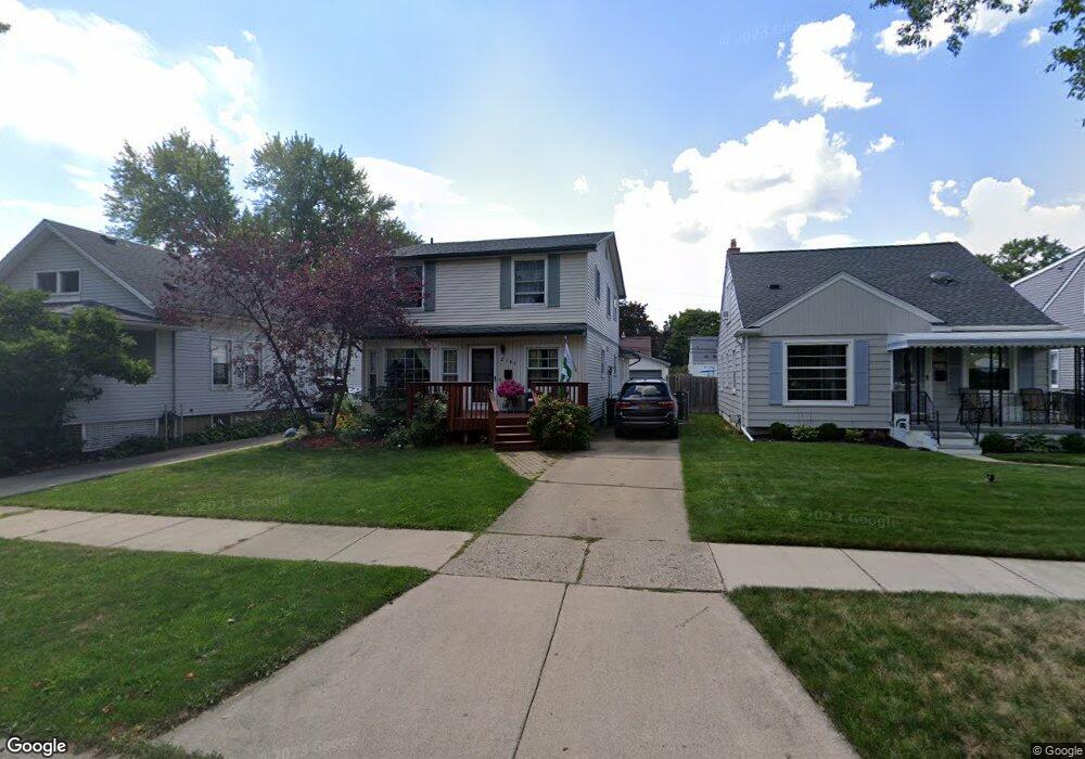
2193 Gardner Ave Berkley, MI 48072
Estimated Value: $378,000 - $545,000
3
Beds
2
Baths
2,128
Sq Ft
$218/Sq Ft
Est. Value
About This Home
This home is located at 2193 Gardner Ave, Berkley, MI 48072 and is currently estimated at $463,313, approximately $217 per square foot. 2193 Gardner Ave is a home located in Oakland County with nearby schools including Angell Elementary School, Anderson Middle School, and Berkley High School.
Ownership History
Date
Name
Owned For
Owner Type
Purchase Details
Closed on
May 25, 2012
Sold by
Smith Elise M and Smith Timothy
Bought by
Smith Timothy
Current Estimated Value
Home Financials for this Owner
Home Financials are based on the most recent Mortgage that was taken out on this home.
Original Mortgage
$193,066
Outstanding Balance
$134,052
Interest Rate
3.87%
Mortgage Type
New Conventional
Estimated Equity
$329,261
Purchase Details
Closed on
Jun 2, 2003
Sold by
Grady Daniel J and Grady Diane G
Bought by
Smith Timothy and Smith Elise M
Create a Home Valuation Report for This Property
The Home Valuation Report is an in-depth analysis detailing your home's value as well as a comparison with similar homes in the area
Home Values in the Area
Average Home Value in this Area
Purchase History
| Date | Buyer | Sale Price | Title Company |
|---|---|---|---|
| Smith Timothy | -- | Transtar National Title | |
| Smith Timothy | $272,000 | -- |
Source: Public Records
Mortgage History
| Date | Status | Borrower | Loan Amount |
|---|---|---|---|
| Open | Smith Timothy | $193,066 |
Source: Public Records
Tax History Compared to Growth
Tax History
| Year | Tax Paid | Tax Assessment Tax Assessment Total Assessment is a certain percentage of the fair market value that is determined by local assessors to be the total taxable value of land and additions on the property. | Land | Improvement |
|---|---|---|---|---|
| 2024 | $4,627 | $193,670 | $0 | $0 |
| 2023 | $4,170 | $182,520 | $0 | $0 |
| 2022 | $4,167 | $168,200 | $0 | $0 |
| 2021 | $4,074 | $165,070 | $0 | $0 |
| 2020 | $3,897 | $163,470 | $0 | $0 |
| 2019 | $4,092 | $151,070 | $0 | $0 |
| 2018 | $3,912 | $131,560 | $0 | $0 |
| 2017 | $3,863 | $130,600 | $0 | $0 |
| 2016 | $4,324 | $127,590 | $0 | $0 |
| 2015 | -- | $118,610 | $0 | $0 |
| 2014 | -- | $107,060 | $0 | $0 |
| 2011 | -- | $94,570 | $0 | $0 |
Source: Public Records
Map
Nearby Homes
- 2085 Gardner Ave
- 3325 Catalpa Dr
- 2907 Sunnyknoll Ave
- 1888 Griffith Ave
- 2756 Buckingham Ave
- 2863 Columbia Rd
- 2519 Phillips Ave
- 2783 Royal Ave
- 1799 Phillips Ave
- 2679 Columbia Rd
- 2678 Bacon Ave
- 14421 Labelle St
- 2435 Sunnyknoll Ave
- 2112 Ellwood Ave
- 14231 Borgman St
- 2716 Thomas Ave
- 14670 Talbot St
- 13680 Borgman St
- 2464 Greenfield Rd
- 14710 Loretta Place
- 2185 Gardner Ave
- 2215 Gardner Ave
- 2163 Gardner Ave
- 2235 Gardner Ave
- 2194 Tyler Ave
- 2236 Tyler Ave
- 2178 Tyler Ave
- 2149 Gardner Ave Unit Bldg-Unit
- 2149 Gardner Ave
- 2216 Tyler Ave
- 2164 Tyler Ave
- 2265 Gardner Ave
- 2150 Tyler Ave
- 2252 Tyler Ave
- 2194 Gardner Ave
- 2178 Gardner Ave
- 2125 Gardner Ave
- 2279 Gardner Ave
- 2132 Tyler Ave
- 2266 Tyler Ave