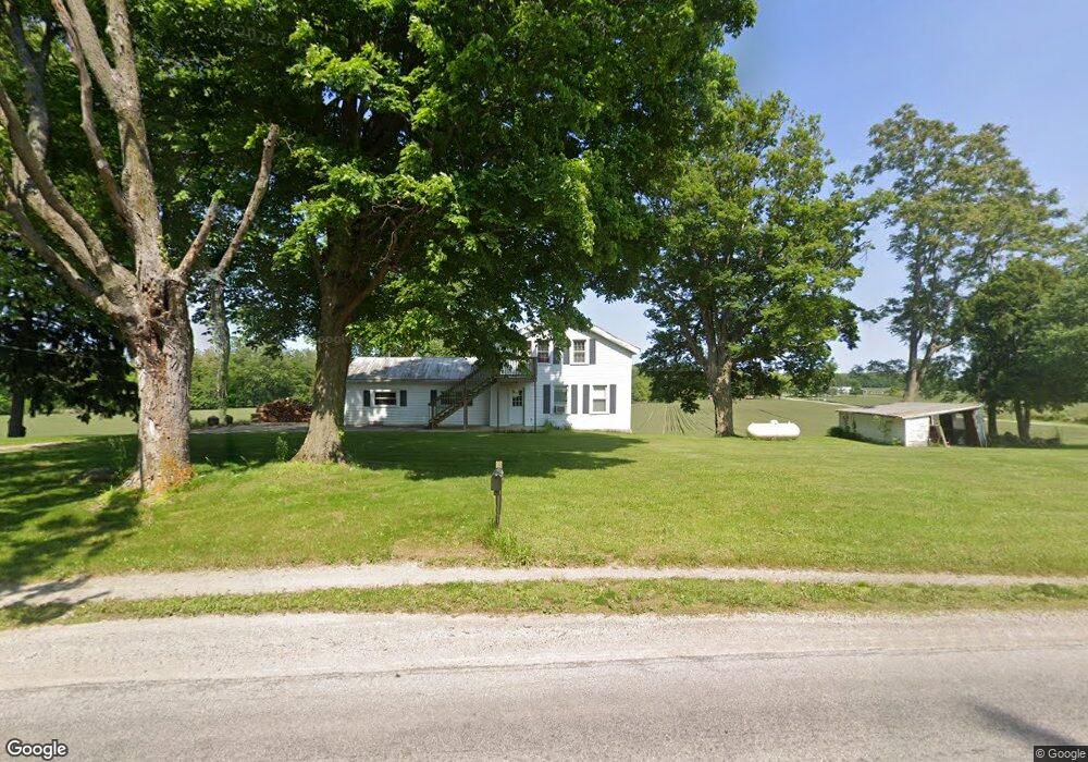
2194 Derussey Rd Norwalk, OH 44857
Estimated Value: $163,035 - $218,000
2
Beds
2
Baths
1,686
Sq Ft
$114/Sq Ft
Est. Value
About This Home
This home is located at 2194 Derussey Rd, Norwalk, OH 44857 and is currently estimated at $192,259, approximately $114 per square foot. 2194 Derussey Rd is a home located in Huron County with nearby schools including Maplehurst Elementary School, Pleasant Elementary School, and League Elementary School.
Ownership History
Date
Name
Owned For
Owner Type
Purchase Details
Closed on
Nov 4, 2014
Sold by
Delapp Craig and Delapp Bonita S
Bought by
Resor Adam L
Current Estimated Value
Home Financials for this Owner
Home Financials are based on the most recent Mortgage that was taken out on this home.
Original Mortgage
$83,435
Outstanding Balance
$64,775
Interest Rate
4.37%
Mortgage Type
FHA
Estimated Equity
$127,484
Purchase Details
Closed on
Dec 31, 2003
Bought by
Delapp Craig
Purchase Details
Closed on
Aug 25, 1997
Sold by
Trst Harry Delapp
Bought by
Harry A & Barbara E Delapp Trustee
Purchase Details
Closed on
Jul 17, 1997
Bought by
Delapp Harry Trustee
Purchase Details
Closed on
May 15, 1989
Bought by
Delapp Alta Trust W/Le A
Create a Home Valuation Report for This Property
The Home Valuation Report is an in-depth analysis detailing your home's value as well as a comparison with similar homes in the area
Home Values in the Area
Average Home Value in this Area
Purchase History
| Date | Buyer | Sale Price | Title Company |
|---|---|---|---|
| Resor Adam L | $85,000 | Hartung Title | |
| Delapp Craig | -- | -- | |
| Harry A & Barbara E Delapp Trustee | $70,000 | -- | |
| Delapp Harry Trustee | -- | -- | |
| Delapp Alta Trust W/Le A | -- | -- |
Source: Public Records
Mortgage History
| Date | Status | Borrower | Loan Amount |
|---|---|---|---|
| Open | Resor Adam L | $83,435 |
Source: Public Records
Tax History Compared to Growth
Tax History
| Year | Tax Paid | Tax Assessment Tax Assessment Total Assessment is a certain percentage of the fair market value that is determined by local assessors to be the total taxable value of land and additions on the property. | Land | Improvement |
|---|---|---|---|---|
| 2024 | $1,462 | $43,240 | $10,260 | $32,980 |
| 2023 | $1,462 | $33,180 | $7,650 | $25,530 |
| 2022 | $1,145 | $33,180 | $7,650 | $25,530 |
| 2021 | $1,182 | $33,180 | $7,650 | $25,530 |
| 2020 | $1,093 | $29,720 | $7,470 | $22,250 |
| 2019 | $1,088 | $29,720 | $7,470 | $22,250 |
| 2018 | $1,076 | $29,720 | $7,470 | $22,250 |
| 2017 | $1,156 | $32,500 | $7,350 | $25,150 |
| 2016 | $1,134 | $32,500 | $7,350 | $25,150 |
| 2015 | $1,042 | $32,510 | $7,350 | $25,160 |
| 2014 | $1,008 | $28,350 | $7,350 | $21,000 |
| 2013 | $997 | $28,350 | $7,350 | $21,000 |
Source: Public Records
Map
Nearby Homes
- 4 Mary Way Unit A
- 29 Olive St
- 120 Woodlawn Ave
- 85 Woodlawn Ave
- 29 Harris Ave
- 15 W Chestnut St
- 11 Granny Smith St
- 48 E Elm St
- 0 Cleveland Rd
- 29 Corwin St
- 50 Norwood Ave
- 40 Norwood Ave
- 14 Whitefield Blvd
- 27 Whitefield Blvd
- 14 Corwin St
- 21 Maple St
- 123 E Main St
- 29 W Seminary St
- 173 Saint Marys St
- 57 Milan Ave
- 2358 Derussey Rd
- 393 Old State Rd S
- 2 Jeffrey Way
- 408 Old State Rd S
- 250 Old State Rd S
- 3279 Old State Rd N
- 72 Executive Dr
- 4 Jeffrey Way
- 421 Old State Rd S
- 410 Old State Rd S
- 248 Old State Rd S
- 6 Jeffrey Way
- 5 Jeffrey Way
- 64 Executive Dr
- 65 Executive Dr
- 8 Jeffrey Way
- 414 Old State Rd S
- 425 Old State Rd S
- 15 Jeffrey Way
- 8 Executive Village Ct Unit A