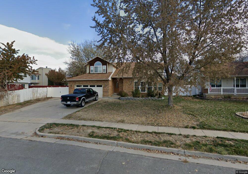
2194 N 1950 E Layton, UT 84040
Estimated Value: $539,000 - $636,000
5
Beds
5
Baths
3,434
Sq Ft
$176/Sq Ft
Est. Value
About This Home
This home is located at 2194 N 1950 E, Layton, UT 84040 and is currently estimated at $604,157, approximately $175 per square foot. 2194 N 1950 E is a home located in Davis County with nearby schools including Sarah Jane Adams Elementary School, North Layton Junior High School, and Northridge High School.
Ownership History
Date
Name
Owned For
Owner Type
Purchase Details
Closed on
Jul 14, 2014
Sold by
Tyrell Tili
Bought by
Tyrell Tili and Tyrell Moira S
Current Estimated Value
Home Financials for this Owner
Home Financials are based on the most recent Mortgage that was taken out on this home.
Original Mortgage
$180,050
Outstanding Balance
$136,433
Interest Rate
4.1%
Mortgage Type
VA
Estimated Equity
$467,724
Purchase Details
Closed on
Dec 1, 2003
Sold by
Jenkins Stanley J and Jenkins Mary Ann
Bought by
Tyrell Tili and Tyrell Moira S
Create a Home Valuation Report for This Property
The Home Valuation Report is an in-depth analysis detailing your home's value as well as a comparison with similar homes in the area
Home Values in the Area
Average Home Value in this Area
Purchase History
| Date | Buyer | Sale Price | Title Company |
|---|---|---|---|
| Tyrell Tili | -- | Backman Title Serv | |
| Tyrell Tili | -- | Backman Title Serv | |
| Tyrell Tili | -- | Mountain View Title & Escrow |
Source: Public Records
Mortgage History
| Date | Status | Borrower | Loan Amount |
|---|---|---|---|
| Open | Tyrell Tili | $180,050 |
Source: Public Records
Tax History
| Year | Tax Paid | Tax Assessment Tax Assessment Total Assessment is a certain percentage of the fair market value that is determined by local assessors to be the total taxable value of land and additions on the property. | Land | Improvement |
|---|---|---|---|---|
| 2025 | $305 | $319,550 | $123,792 | $195,758 |
| 2024 | $285 | $306,350 | $147,746 | $158,604 |
| 2023 | $263 | $538,000 | $199,490 | $338,510 |
| 2022 | $502 | $309,650 | $106,981 | $202,669 |
| 2021 | $237 | $410,000 | $162,775 | $247,225 |
| 2020 | $2,703 | $359,000 | $131,643 | $227,357 |
| 2019 | $2,651 | $347,000 | $117,631 | $229,369 |
| 2018 | $2,397 | $314,000 | $91,447 | $222,553 |
| 2016 | $2,172 | $149,435 | $48,158 | $101,277 |
| 2015 | $2,128 | $139,040 | $48,158 | $90,882 |
| 2014 | $2,119 | $141,694 | $48,158 | $93,536 |
| 2013 | -- | $124,115 | $25,032 | $99,083 |
Source: Public Records
Map
Nearby Homes
- 2189 N 1950 E
- 2273 N 1975 E
- 2340 N 2050 E
- 3142 E Thorley Dr
- 2096 N 1450 E
- 1540 E Primrose Ln
- 1444 E 2400 N
- 1465 E Sego Lily Ct
- 2202 N 2300 E
- 1907 N Bridge Ct
- 1843 Hayes Dr
- 1476 Kays Creek Dr
- 1930 N Camellia Way E Unit 407
- 1920 N Camellia Way Unit 406
- 2597 N 2300 E
- 1120 E 2200 N
- 1099 E 2125 N
- 1447 E 2700 N
- 1731 E 2825 N
- 1785 E 2825 N
Your Personal Tour Guide
Ask me questions while you tour the home.