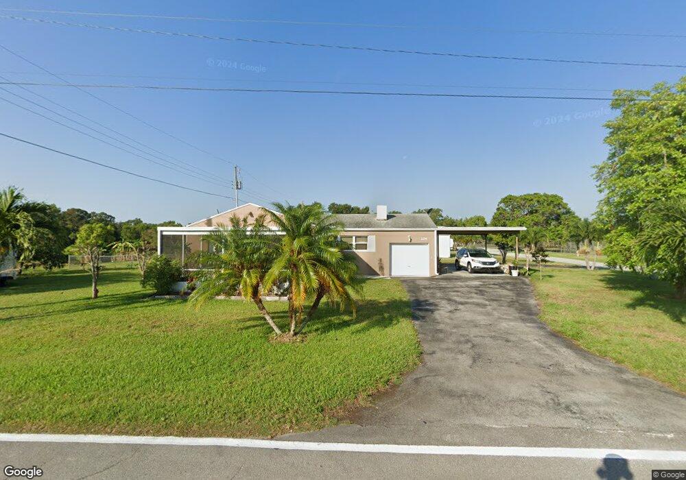
2196 SW Locks Rd Stuart, FL 34997
South Stuart NeighborhoodEstimated Value: $352,000 - $426,000
2
Beds
1
Bath
1,387
Sq Ft
$283/Sq Ft
Est. Value
About This Home
This home is located at 2196 SW Locks Rd, Stuart, FL 34997 and is currently estimated at $392,563, approximately $283 per square foot. 2196 SW Locks Rd is a home located in Martin County with nearby schools including Crystal Lake Elementary School, Dr. David L. Anderson Middle School, and South Fork High School.
Ownership History
Date
Name
Owned For
Owner Type
Purchase Details
Closed on
Nov 29, 2017
Sold by
Robbins Arthur J and Robbins Beverly A
Bought by
Robbins Arthur J and Robbins Beverly A
Current Estimated Value
Purchase Details
Closed on
Jun 10, 2014
Sold by
Isom Mary Ruth
Bought by
Robbins Family Trust and Robbins Beverly A
Purchase Details
Closed on
Aug 1, 1965
Bought by
Robbins Arthur J Co-Tr and Robbins Beverly A Co-Tr
Create a Home Valuation Report for This Property
The Home Valuation Report is an in-depth analysis detailing your home's value as well as a comparison with similar homes in the area
Home Values in the Area
Average Home Value in this Area
Purchase History
| Date | Buyer | Sale Price | Title Company |
|---|---|---|---|
| Robbins Arthur J | -- | None Available | |
| Robbins Family Trust | $71,400 | Lake Okeechobee Title Inc | |
| Robbins Arthur J Co-Tr | $8,000 | -- |
Source: Public Records
Tax History
| Year | Tax Paid | Tax Assessment Tax Assessment Total Assessment is a certain percentage of the fair market value that is determined by local assessors to be the total taxable value of land and additions on the property. | Land | Improvement |
|---|---|---|---|---|
| 2025 | $1,530 | $131,350 | -- | -- |
| 2024 | $1,467 | $127,649 | -- | -- |
| 2023 | $1,467 | $123,932 | $0 | $0 |
| 2022 | $1,391 | $120,323 | $0 | $0 |
| 2021 | $1,359 | $116,819 | $0 | $0 |
| 2020 | $1,268 | $115,207 | $0 | $0 |
| 2019 | $1,238 | $112,617 | $0 | $0 |
| 2018 | $1,204 | $110,517 | $0 | $0 |
| 2017 | $803 | $108,244 | $0 | $0 |
| 2016 | $1,109 | $106,017 | $0 | $0 |
| 2015 | $2,028 | $105,280 | $67,500 | $37,780 |
| 2014 | $2,028 | $107,120 | $72,000 | $35,120 |
Source: Public Records
Map
Nearby Homes
- 1800 SW Hackman Terrace
- 1944 SW College St
- 8006 SW Yachtsmans Dr
- 0 Unassigned St Unit R11141160
- 8388 SW Masthead Dr
- 2242 SW Panther Trace
- 1420 SW Belgrave Terrace
- 2189 SW Panther Trace
- 2136 SW Panther Trace
- 1286 SW Tropical Terrace
- 1201 SW Sunshine St
- 2650 SW Windship Way
- 8300 SW Cattleya Dr
- 8121 SW Marin Dr
- 1245 SW Kanner Hwy
- 8888 SW Fishermans Wharf Dr
- 8821 SW Kanner Oaks Dr
- 8831 SW Kanner Oaks Dr
- 8895 SW Fishermans Wharf Dr
- 8841 SW Kanner Oaks Dr
- 2222 SW Canal St
- 2195 SW Locks Rd
- 2242 SW Canal St
- 2129 SW Locks Rd
- 2133 SW Locks Rd
- 2155 SW Locks Rd
- 2135 SW Locks Rd
- 1900 SW Belgrave Terrace
- 1907 SW Belgrave Terrace
- 2145 SW Locks Rd
- 1880 SW Belgrave Terrace
- 8057 SW Yachtsmans Dr
- 7102 SW Gembrook Dr
- 2075 SW Hackman Terrace
- 8065 SW Yachtsmans Dr
- 8061 SW Yachtsmans Dr
- 8069 SW Yachtsmans Dr
- 2129 SW Hackman Tc
- 1887 SW Belgrave Terrace
- 2171 SW Oasis Terrace