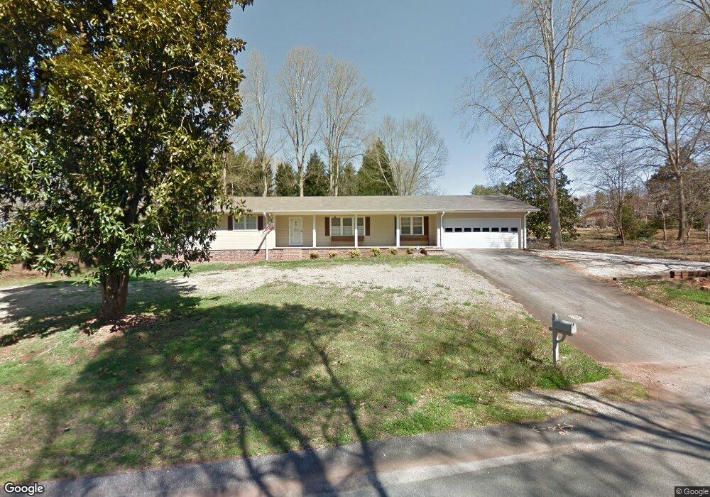
22 Abbott Ln Walhalla, SC 29691
Estimated Value: $293,000 - $377,000
3
Beds
2
Baths
1,942
Sq Ft
$175/Sq Ft
Est. Value
About This Home
This home is located at 22 Abbott Ln, Walhalla, SC 29691 and is currently estimated at $340,107, approximately $175 per square foot. 22 Abbott Ln is a home located in Oconee County with nearby schools including Walhalla Elementary School, Walhalla Middle School, and Walhalla High School.
Ownership History
Date
Name
Owned For
Owner Type
Purchase Details
Closed on
Oct 9, 2012
Sold by
Peeler H James and Peeler Margaret C
Bought by
Watson William J and Watson John David
Current Estimated Value
Home Financials for this Owner
Home Financials are based on the most recent Mortgage that was taken out on this home.
Original Mortgage
$111,000
Outstanding Balance
$76,642
Interest Rate
3.6%
Mortgage Type
New Conventional
Estimated Equity
$263,465
Purchase Details
Closed on
Jul 17, 2009
Sold by
Johns Kenneth E and Johns Kenneth E
Bought by
Peeler H James and Peeler Margaret C
Create a Home Valuation Report for This Property
The Home Valuation Report is an in-depth analysis detailing your home's value as well as a comparison with similar homes in the area
Home Values in the Area
Average Home Value in this Area
Purchase History
| Date | Buyer | Sale Price | Title Company |
|---|---|---|---|
| Watson William J | $136,000 | -- | |
| Peeler H James | $133,000 | -- |
Source: Public Records
Mortgage History
| Date | Status | Borrower | Loan Amount |
|---|---|---|---|
| Open | Watson William J | $111,000 |
Source: Public Records
Tax History
| Year | Tax Paid | Tax Assessment Tax Assessment Total Assessment is a certain percentage of the fair market value that is determined by local assessors to be the total taxable value of land and additions on the property. | Land | Improvement |
|---|---|---|---|---|
| 2025 | $2,092 | $10,838 | $432 | $10,406 |
| 2024 | $2,070 | $10,838 | $432 | $10,406 |
| 2023 | $1,027 | $5,480 | $510 | $4,970 |
| 2022 | $1,027 | $5,480 | $510 | $4,970 |
| 2021 | $1,014 | $5,210 | $510 | $4,700 |
| 2020 | $565 | $5,210 | $510 | $4,700 |
| 2019 | $565 | $0 | $0 | $0 |
| 2018 | $1,141 | $0 | $0 | $0 |
| 2017 | $1,014 | $0 | $0 | $0 |
| 2016 | $1,014 | $0 | $0 | $0 |
| 2015 | -- | $0 | $0 | $0 |
| 2014 | -- | $5,452 | $752 | $4,701 |
| 2013 | -- | $0 | $0 | $0 |
Source: Public Records
Map
Nearby Homes
- 00 Abbott Ln
- 00 N Church St
- 147 White Oak St
- 00 Fox Run Rd
- 323 Fox Run Rd
- Lot 57 Fox Run Rd
- 221 Cub Cove Dr
- 101 Hazelwood Way
- 324 Fox Run Rd
- 223 N Dogwood Dr
- 606 N Poplar St
- 209 Moore Ave
- 807 W Main St
- Tract B Bobolink Dr
- 804 W North Broad St
- 00 Keowee St
- 606 W South Broad St
- 204 Friendship Dr
- 320 Jaynes St
- 384 E Woodland Dr
- 49 - 53 Abbott Ln Unit Lots 16,17,18 Green
- 115 Letson Cir
- 109 Letson Cir
- 121 Letson Cir
- 21 Abbott Ln
- 21 Abbott Ln Unit LT 19, 20 21 Green A
- 103 Letson Cir
- 105 Playground Rd
- 107 Playground Rd
- 165 Letson Cir
- 106 Cherokee Dr
- 104 Playground Rd
- 104 Playground Rd
- 106 Playground Rd
- 107 Cherokee Dr
- 112 Cherokee Dr
- 444 N Church St
- 30 Lakeshore Dr
- 604 N Catherine St
- 202 Playground Rd
Your Personal Tour Guide
Ask me questions while you tour the home.