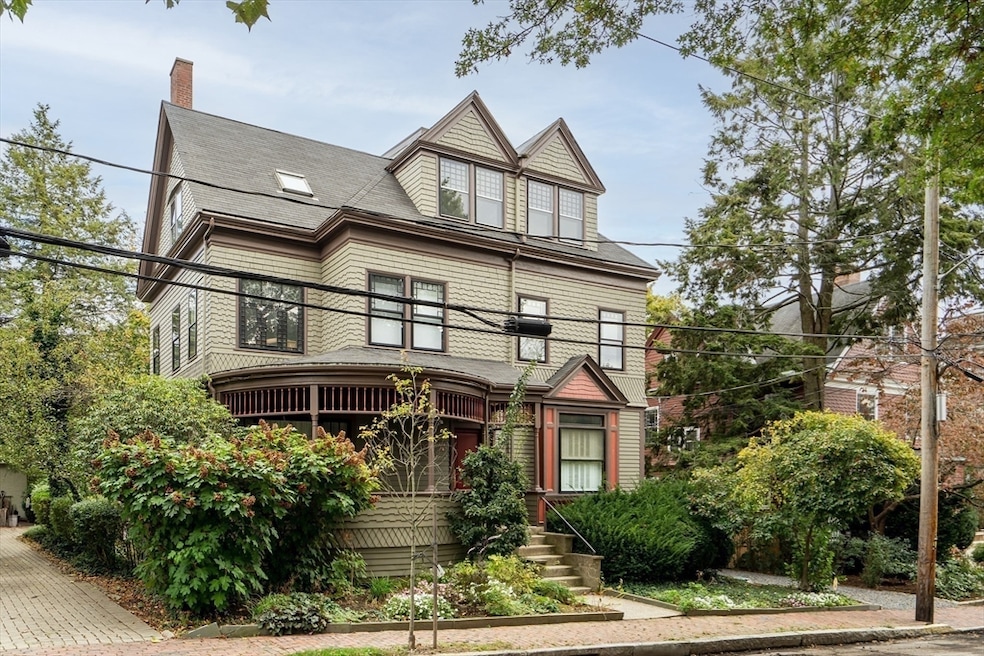

22 Agassiz St Cambridge, MA 02140
Neighborhood Nine NeighborhoodEstimated payment $11,628/month
Highlights
- Sauna
- Property is near public transit
- Loft
- Deck
- Wood Flooring
- 2 Fireplaces
About This Home
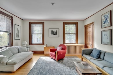
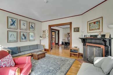
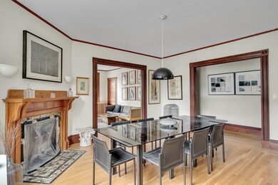
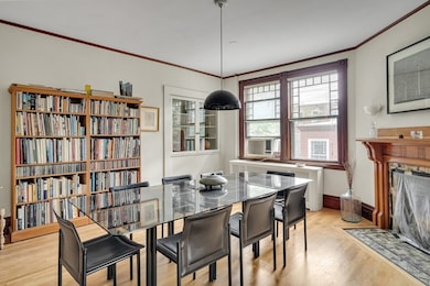
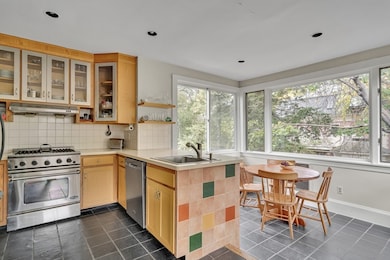
Rare opportunity. In an 1888 Queen Anne, this 3,010 sq. ft. condo retains its historic character while offering features for today’s living. The first level presents a delightful morning room, fire-placed living and dining rooms, a spacious study, a full bathroom, and a kitchen where the steel, glass, and wood of the cabinet design blend old and new elements, and expansive sliding windows overlook a serene view The upper level boasts four bedrooms, one with an en-suite full bath, and one with an en-suite half-bath, plus another full bath. An observatory holds a sauna and offers a unique space for spectacular views over the Boston skyline. Interiors are rich, with high ceilings, intricate woodwork, and an abundance of natural light. Nestled in the Avon Hill neighborhood, this home offers the perfect combination of urban convenience and historical attraction. A quintessential Cambridge treasure.
Property Details
Home Type
- Condominium
Est. Annual Taxes
- $15,882
Year Built
- Built in 1888
Lot Details
- Fenced Yard
- Garden
Parking
- 1 Car Detached Garage
- Unpaved Parking
- Open Parking
- Off-Street Parking
- Assigned Parking
Home Design
- Entry on the 2nd floor
- Shingle Siding
Interior Spaces
- 3,010 Sq Ft Home
- 3-Story Property
- Skylights
- 2 Fireplaces
- Loft
- Sauna
- Basement
- Laundry in Basement
- ENERGY STAR Qualified Washer
Kitchen
- Range
- ENERGY STAR Qualified Refrigerator
- ENERGY STAR Qualified Dishwasher
Flooring
- Wood
- Tile
Bedrooms and Bathrooms
- 4 Bedrooms
- Primary bedroom located on second floor
Outdoor Features
- Deck
Location
- Property is near public transit
- Property is near schools
Utilities
- No Cooling
- Heating System Uses Natural Gas
- Hot Water Heating System
- Electric Baseboard Heater
Listing and Financial Details
- Assessor Parcel Number M:00176 L:0005700022,412055
Community Details
Overview
- 2 Units
- 22 24 Agassiz Street Condominium Community
Amenities
- Common Area
- Shops
- Laundry Facilities
Recreation
- Park
Pet Policy
- Call for details about the types of pets allowed
Map
Home Values in the Area
Average Home Value in this Area
Tax History
| Year | Tax Paid | Tax Assessment Tax Assessment Total Assessment is a certain percentage of the fair market value that is determined by local assessors to be the total taxable value of land and additions on the property. | Land | Improvement |
|---|---|---|---|---|
| 2025 | $15,882 | $2,501,100 | $0 | $2,501,100 |
| 2024 | $15,917 | $2,688,700 | $0 | $2,688,700 |
| 2023 | $14,088 | $2,404,100 | $0 | $2,404,100 |
| 2022 | $14,052 | $2,373,600 | $0 | $2,373,600 |
| 2021 | $13,650 | $2,333,300 | $0 | $2,333,300 |
| 2020 | $12,528 | $2,178,800 | $0 | $2,178,800 |
| 2019 | $12,034 | $2,026,000 | $0 | $2,026,000 |
| 2018 | $9,863 | $1,864,300 | $0 | $1,864,300 |
| 2017 | $11,744 | $1,809,500 | $0 | $1,809,500 |
| 2016 | $11,489 | $1,643,700 | $0 | $1,643,700 |
| 2015 | $11,408 | $1,458,800 | $0 | $1,458,800 |
| 2014 | $11,280 | $1,346,100 | $0 | $1,346,100 |
Property History
| Date | Event | Price | List to Sale | Price per Sq Ft |
|---|---|---|---|---|
| 11/05/2025 11/05/25 | Pending | -- | -- | -- |
| 10/29/2025 10/29/25 | For Sale | $1,955,000 | -- | $650 / Sq Ft |
Purchase History
| Date | Type | Sale Price | Title Company |
|---|---|---|---|
| Deed | $620,000 | -- |
Mortgage History
| Date | Status | Loan Amount | Loan Type |
|---|---|---|---|
| Closed | $350,000 | No Value Available | |
| Closed | $340,000 | Purchase Money Mortgage |
Source: MLS Property Information Network (MLS PIN)
MLS Number: 73449057
APN: CAMB-000176-000000-000057-000022
Disclaimer: Certain information contained herein is derived from information provided by parties other than Homes.com. All information provided is deemed reliable, but is not guaranteed to be accurate and should be independently verified.
![]() The property listing data and information, or the Images, set forth herein were provided to MLS Property Information Network, Inc. from third party sources, including sellers, lessors and public records, and were compiled by MLS Property Information Network, Inc. The property listing data and information, and the Images, are for the personal, non-commercial use of consumers having a good faith interest in purchasing or leasing listed properties of the type displayed to them and may not be used for any purpose other than to identify prospective properties which such consumers may have a good faith interest in purchasing or leasing. MLS Property Information Network, Inc. and its subscribers disclaim any and all representations and warranties as to the accuracy of the property listing data and information, or as to the accuracy of any of the Images, set forth herein.
The property listing data and information, or the Images, set forth herein were provided to MLS Property Information Network, Inc. from third party sources, including sellers, lessors and public records, and were compiled by MLS Property Information Network, Inc. The property listing data and information, and the Images, are for the personal, non-commercial use of consumers having a good faith interest in purchasing or leasing listed properties of the type displayed to them and may not be used for any purpose other than to identify prospective properties which such consumers may have a good faith interest in purchasing or leasing. MLS Property Information Network, Inc. and its subscribers disclaim any and all representations and warranties as to the accuracy of the property listing data and information, or as to the accuracy of any of the Images, set forth herein.
- 33 Agassiz St
- 86 Avon Hill St
- 3 Arlington St Unit 52
- 43 Linnaean St Unit 42
- 1783 Massachusetts Ave Unit B
- 55 Raymond St
- 1 Richdale Ave Unit 2
- 15-15A Forest St
- 70 Walden St Unit 1
- 70 Walden St Unit 7
- 70 Walden St Unit 11
- 137 Walden St Unit 137
- 241 Upland Rd Unit 2
- 69A Walker St Unit A
- 202 Garden St
- 84 Garden St
- 32-40 White St
- 12 Mossland St
- 1963 Massachusetts Ave Unit 404
- 14 Mossland St
