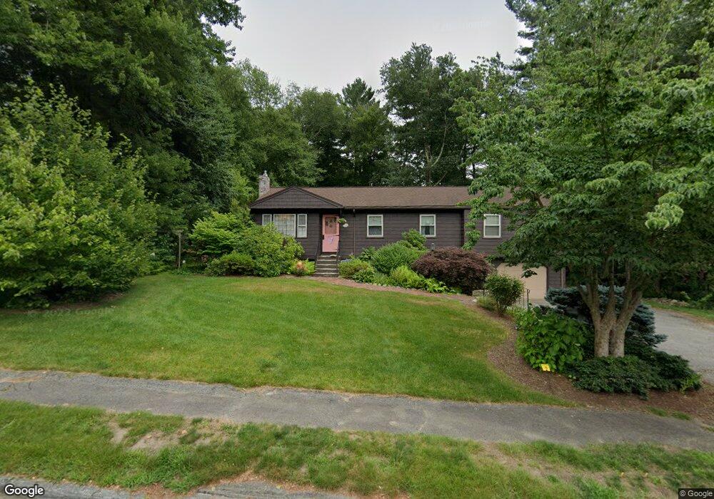
22 Andrew Ln Holliston, MA 01746
Estimated Value: $650,000 - $707,000
4
Beds
2
Baths
1,516
Sq Ft
$445/Sq Ft
Est. Value
About This Home
This home is located at 22 Andrew Ln, Holliston, MA 01746 and is currently estimated at $675,067, approximately $445 per square foot. 22 Andrew Ln is a home located in Middlesex County with nearby schools including Miller Elementary School, Robert H. Adams Middle School, and Holliston High School.
Ownership History
Date
Name
Owned For
Owner Type
Purchase Details
Closed on
Jul 2, 2018
Sold by
Stucchi Anthony and Stucchi Gretchen
Bought by
Anthony & G Stucchi Ft and Stucchi
Current Estimated Value
Purchase Details
Closed on
Jan 1, 1970
Bought by
Stucchi Anthony and Stucchi Gretchen
Create a Home Valuation Report for This Property
The Home Valuation Report is an in-depth analysis detailing your home's value as well as a comparison with similar homes in the area
Home Values in the Area
Average Home Value in this Area
Purchase History
| Date | Buyer | Sale Price | Title Company |
|---|---|---|---|
| Anthony & G Stucchi Ft | -- | -- | |
| Anthony & G Stucchi Ft | -- | -- | |
| Stucchi Anthony | -- | -- |
Source: Public Records
Mortgage History
| Date | Status | Borrower | Loan Amount |
|---|---|---|---|
| Previous Owner | Stucchi Anthony | $70,000 |
Source: Public Records
Tax History Compared to Growth
Tax History
| Year | Tax Paid | Tax Assessment Tax Assessment Total Assessment is a certain percentage of the fair market value that is determined by local assessors to be the total taxable value of land and additions on the property. | Land | Improvement |
|---|---|---|---|---|
| 2025 | $7,681 | $524,300 | $261,800 | $262,500 |
| 2024 | $7,069 | $469,400 | $261,800 | $207,600 |
| 2023 | $7,095 | $460,700 | $261,800 | $198,900 |
| 2022 | $6,982 | $401,700 | $261,800 | $139,900 |
| 2021 | $7,010 | $392,700 | $249,800 | $142,900 |
| 2020 | $6,884 | $365,200 | $227,300 | $137,900 |
| 2019 | $6,752 | $358,600 | $220,700 | $137,900 |
| 2018 | $6,695 | $358,600 | $220,700 | $137,900 |
| 2017 | $6,975 | $376,600 | $225,200 | $151,400 |
| 2016 | $6,484 | $345,100 | $193,700 | $151,400 |
| 2015 | $6,039 | $311,600 | $158,900 | $152,700 |
Source: Public Records
Map
Nearby Homes
- 75 Ridge Rd
- 263 Chamberlain St
- 30 Arthur St
- 56 Paul Rd
- 110 Bonney Dr
- Lot 2 Hanlon Rd
- 1014 Highland St
- 20 Hargrave Ave
- 1037 Washington St
- 154 Union St
- 43 Bittersweet Cir Unit 43
- 1366 Washington St
- 15 Broad Acres Farm Rd
- 10 Oak St
- 2 Emerald Dr
- 12 Longmeadow Ln
- 1 Emerald Dr
- 7 Hill St
- 116 Winthrop St
- 160 Winter St
- 0 Lot 6 Juniper Rd Unit 50378279
- 8 Lot 8 Juniper Rd
- 30 Andrew Ln
- 23 Andrew Ln
- 18 Juniper Rd Unit 151
- 15 Andrew Ln
- 0 Lot#20 Juniper Rd Unit 50261135
- 383 Chamberlain St
- 31 Andrew Ln
- 44 Andrew Ln
- 369 Chamberlain St
- 22 Juniper Rd
- 39 Andrew Ln
- 391 Chamberlain St
- 30 Juniper Rd
- 21 Juniper Rd
- 47 Andrew Ln
- 52 Andrew Ln
- 362 Chamberlain St
- 0 Lot 15a Juniper Rd Unit 50335029