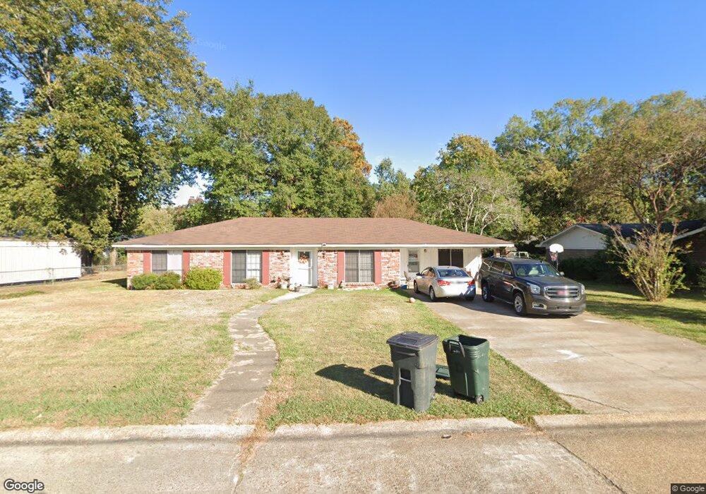
22 Audubon Dr Monroe, LA 71203
Estimated Value: $157,000 - $176,000
3
Beds
2
Baths
1,870
Sq Ft
$88/Sq Ft
Est. Value
About This Home
This home is located at 22 Audubon Dr, Monroe, LA 71203 and is currently estimated at $165,330, approximately $88 per square foot. 22 Audubon Dr is a home located in Ouachita Parish with nearby schools including Jack Hayes Elementary School, Ouachita Junior High School, and Ouachita Parish High School.
Ownership History
Date
Name
Owned For
Owner Type
Purchase Details
Closed on
Nov 19, 2014
Sold by
Miller Edward Kern and Miller Michelle
Bought by
Lagniappe Investors 103 Llc
Current Estimated Value
Purchase Details
Closed on
Jul 15, 2014
Sold by
Cooper Dennis Terrell and Cooper Kisha Richard
Bought by
Us Bank Na
Purchase Details
Closed on
Apr 30, 2014
Sold by
Cooper Dennis Terrell and Cooper Kisha Richard
Bought by
Wells Fargo
Purchase Details
Closed on
Jun 28, 2013
Sold by
Reddick Mattie and Brooks Theresa
Bought by
Hartwell Frankie Mae
Create a Home Valuation Report for This Property
The Home Valuation Report is an in-depth analysis detailing your home's value as well as a comparison with similar homes in the area
Purchase History
| Date | Buyer | Sale Price | Title Company |
|---|---|---|---|
| Lagniappe Investors 103 Llc | -- | None Available | |
| Us Bank Na | $62,667 | None Available | |
| Wells Fargo | $62,667 | None Available | |
| Hartwell Frankie Mae | -- | None Available |
Source: Public Records
Tax History
| Year | Tax Paid | Tax Assessment Tax Assessment Total Assessment is a certain percentage of the fair market value that is determined by local assessors to be the total taxable value of land and additions on the property. | Land | Improvement |
|---|---|---|---|---|
| 2025 | $416 | $2,215 | $1,445 | $770 |
| 2024 | $416 | $9,428 | $1,445 | $7,983 |
| 2023 | $419 | $9,428 | $1,445 | $7,983 |
| 2022 | $1,419 | $9,428 | $1,445 | $7,983 |
| 2021 | $1,430 | $10,198 | $1,445 | $8,753 |
| 2020 | $1,465 | $10,378 | $1,615 | $8,763 |
| 2019 | $1,445 | $10,378 | $1,615 | $8,763 |
| 2018 | $392 | $10,378 | $1,615 | $8,763 |
| 2017 | $1,401 | $10,314 | $1,615 | $8,699 |
| 2016 | $1,370 | $10,756 | $1,615 | $9,141 |
| 2015 | $391 | $10,756 | $1,615 | $9,141 |
| 2014 | $397 | $10,378 | $1,558 | $8,820 |
| 2013 | $406 | $10,378 | $1,615 | $8,763 |
Source: Public Records
Map
Nearby Homes
- 24 Elmwood Dr
- 10 Rosewood Dr
- 26 Karen Ln
- 31 Azalea Dr
- 26 Jana Dr
- 37 W Elmwood Dr
- 308 Woodale Dr Unit 2
- 314 Woodale Dr
- 303 Woodale Dr
- 55 Magnolia Dr
- 117 Oak Cir
- 0 Old Sterlington Rd
- 101 Tulip Wood Dr Unit 1
- 0 Sterlington Rd
- 219 Sterlington Dr
- 226 Monroe Dr
- 211 Cotton Trace Dr
- 000 Stubbs Vinson Rd
- 311 Birdie Ln
- 256 N Leo Ln