
22 Depot Ln Belfast, ME 04915
Estimated payment $690/month
Highlights
- 2.5 Acre Lot
- No HOA
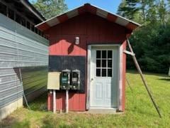
- Shed
About This Lot
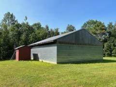
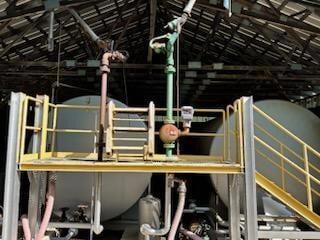
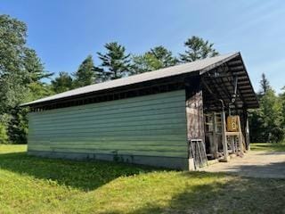
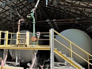
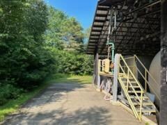
This property features a 40' x 58' building with a concrete berm and tank shelter, which houses 2 above ground fuel tanks.
1- 10,000 gallon and 1 - 15,000 gallon tank, used previously for the storage of petroleum products. The tank shelter has a concrete pad measuring 15'6'' x 40'. There is also a separate 8' x 10' shed on the property. Close to downtown Belfast. Call us on this property today.
Property Details
Property Type
- Land
Est. Annual Taxes
- $2,033
Lot Details
- 2.5 Acre Lot
- Dirt Road
- Street terminates at a dead end
- Property is zoned Searspt Ave Comm
Parking
- Gravel Driveway
- On-Street Parking
Utilities
- Natural Gas Not Available
- Water Not Available
- Sewer Not Available
Listing and Financial Details
- Tax Lot 32
- Assessor Parcel Number BELF-000007-000000-000032
Community Details
Overview
- No Home Owners Association
Recreation
- Shed
- Outbuilding
Map
Home Values in the Area
Average Home Value in this Area
Tax History
| Year | Tax Paid | Tax Assessment Tax Assessment Total Assessment is a certain percentage of the fair market value that is determined by local assessors to be the total taxable value of land and additions on the property. | Land | Improvement |
|---|---|---|---|---|
| 2024 | $4,072 | $264,400 | $207,000 | $57,400 |
| 2023 | $1,910 | $95,000 | $29,800 | $65,200 |
| 2022 | $2,033 | $95,000 | $29,800 | $65,200 |
| 2021 | $2,090 | $95,000 | $29,800 | $65,200 |
| 2020 | $2,728 | $117,100 | $39,600 | $77,500 |
| 2019 | $2,395 | $104,600 | $39,600 | $65,000 |
| 2018 | $2,374 | $104,600 | $39,600 | $65,000 |
| 2017 | $2,291 | $104,600 | $39,600 | $65,000 |
| 2016 | $2,388 | $104,300 | $39,300 | $65,000 |
| 2015 | $2,336 | $104,300 | $39,300 | $65,000 |
| 2014 | $2,258 | $104,300 | $39,300 | $65,000 |
| 2013 | $2,169 | $104,300 | $39,300 | $65,000 |
Property History
| Date | Event | Price | List to Sale | Price per Sq Ft |
|---|---|---|---|---|
| 08/01/2025 08/01/25 | Price Changed | $99,000 | 0.0% | -- |
| 08/01/2025 08/01/25 | For Sale | $99,000 | -10.0% | -- |
| 07/31/2025 07/31/25 | Off Market | $110,000 | -- | -- |
| 03/10/2025 03/10/25 | Price Changed | $110,000 | -26.7% | -- |
| 11/05/2024 11/05/24 | Price Changed | $150,000 | -11.8% | -- |
| 08/01/2024 08/01/24 | For Sale | $170,000 | 0.0% | -- |
| 07/31/2024 07/31/24 | Off Market | $170,000 | -- | -- |
| 07/25/2024 07/25/24 | Price Changed | $170,000 | -8.1% | -- |
| 05/06/2024 05/06/24 | Price Changed | $185,000 | -7.5% | -- |
| 04/16/2024 04/16/24 | Price Changed | $200,000 | -20.0% | -- |
| 08/08/2023 08/08/23 | For Sale | $250,000 | -- | -- |
Source: Maine Listings
MLS Number: 1568050
Disclaimer: Certain information contained herein is derived from information provided by parties other than Homes.com. All information provided is deemed reliable, but is not guaranteed to be accurate and should be independently verified.
![]() Listing data is derived in whole or in part from Maine Real Estate Information System, Inc. (d/b/a Maine Listings) and is for consumers' personal, noncommercial use only. Dimensions are approximate and not guaranteed. All data should be independently verified.
Listing data is derived in whole or in part from Maine Real Estate Information System, Inc. (d/b/a Maine Listings) and is for consumers' personal, noncommercial use only. Dimensions are approximate and not guaranteed. All data should be independently verified.
© 2025 Maine Real Estate Information System, Inc. All Rights Reserved. Equal Housing Opportunity.
Homes.com, LLC, 17600 Laguna Canyon Rd Irvine, CA 92618 (888)-952-6393
![]()
- 3 Porter Rd
- 22 Porter Rd
- 90 Searsport Ave
- Lot 1A Belle Point Rd
- Lot 1 Belle Point Rd
- 361 W Main St
- 27 Highview Terrace
- 343 W Main St
- 35 Trout Brook Ln
- 27 Trout Brook Ln
- 41 Sandy Ridge Ln
- 39 Sandy Ridge Ln
- 40 Sandy Ridge Ln
- 10 Serenity Ln
- Mp 1 Lt 43 Our Way
- 16 Cottage St
- 73 Swan Lake Ave
- 1 Miller St
- 19 Glenview Ln
- 2 Swan Lake Ave
- 60 Doak Rd
- 144 Upper Bluff Rd Unit A
- 74 Battle Ave Unit B
- 5 West Dr
- 103 US Route 1 Unit 3upstairsunit
- 18 Wenbelle Dr Unit 328
- 18 Wenbelle Dr Unit 302
- 6 Wenbelle Dr Unit 123
- 3 Cushing St Unit 2
- 12 Free St
- 1 Norwood Ave Unit B
- 153 Clark Rd Unit A
- 1 Pine Grove Dr
- 2213 Western Ave Unit C
- 1318 Bald Mountain Rd
- 167 Kennebec Rd Unit 12
- 128 Mayo Rd Unit F
- 148 Mayo Rd
- 1374 Bucksport Rd Unit 1
- 32 Emerson Mill Rd Unit 6
