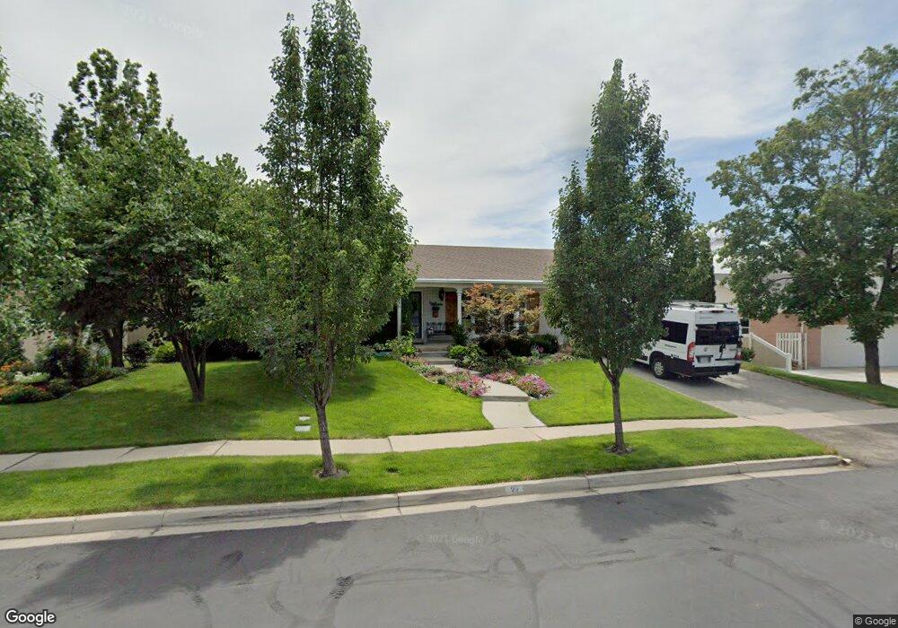
22 E 1010 N American Fork, UT 84003
Estimated Value: $581,000 - $588,378
3
Beds
2
Baths
1,626
Sq Ft
$359/Sq Ft
Est. Value
About This Home
This home is located at 22 E 1010 N, American Fork, UT 84003 and is currently estimated at $583,793, approximately $359 per square foot. 22 E 1010 N is a home located in Utah County with nearby schools including Shelley Elementary School, American Fork Junior High School, and American Fork High School.
Ownership History
Date
Name
Owned For
Owner Type
Purchase Details
Closed on
Dec 18, 2024
Sold by
Warnock D Carl D and Warnock Cindy H
Bought by
Warnock Family Trust and Warnock
Current Estimated Value
Purchase Details
Closed on
Jun 2, 2014
Sold by
Boss Timothy K and Boss Delenca K
Bought by
Warnock D Carl and Warnock Cindy H
Purchase Details
Closed on
Aug 24, 2010
Sold by
Boss Timothy K and Boss Delanea
Bought by
Boss Timothy K and Boss Delanea K
Home Financials for this Owner
Home Financials are based on the most recent Mortgage that was taken out on this home.
Original Mortgage
$262,000
Interest Rate
4.52%
Mortgage Type
New Conventional
Purchase Details
Closed on
Jun 30, 2005
Sold by
Devey Carl E and Devey Carol Ann
Bought by
Boss Timothy K and Boss Delanea
Home Financials for this Owner
Home Financials are based on the most recent Mortgage that was taken out on this home.
Original Mortgage
$150,000
Interest Rate
5.65%
Mortgage Type
Fannie Mae Freddie Mac
Create a Home Valuation Report for This Property
The Home Valuation Report is an in-depth analysis detailing your home's value as well as a comparison with similar homes in the area
Home Values in the Area
Average Home Value in this Area
Purchase History
| Date | Buyer | Sale Price | Title Company |
|---|---|---|---|
| Warnock Family Trust | -- | None Listed On Document | |
| Warnock D Carl | -- | Meridian Title Co | |
| Boss Timothy K | -- | Greenbrier Title Insurance | |
| Boss Timothy K | -- | Affiliated First Title Comp |
Source: Public Records
Mortgage History
| Date | Status | Borrower | Loan Amount |
|---|---|---|---|
| Previous Owner | Boss Timothy K | $262,000 | |
| Previous Owner | Boss Timothy K | $150,000 |
Source: Public Records
Tax History
| Year | Tax Paid | Tax Assessment Tax Assessment Total Assessment is a certain percentage of the fair market value that is determined by local assessors to be the total taxable value of land and additions on the property. | Land | Improvement |
|---|---|---|---|---|
| 2025 | $2,503 | $319,550 | -- | -- |
| 2024 | $2,503 | $278,135 | $0 | $0 |
| 2023 | $2,316 | $272,800 | $0 | $0 |
| 2022 | $2,568 | $298,485 | $0 | $0 |
| 2021 | $2,178 | $395,400 | $130,900 | $264,500 |
| 2020 | $2,054 | $361,800 | $116,900 | $244,900 |
| 2019 | $1,855 | $337,900 | $105,900 | $232,000 |
| 2018 | $1,740 | $303,000 | $98,600 | $204,400 |
| 2017 | $1,574 | $147,950 | $0 | $0 |
| 2016 | $1,615 | $141,020 | $0 | $0 |
| 2015 | -- | $138,985 | $0 | $0 |
| 2014 | $1,547 | $126,500 | $0 | $0 |
Source: Public Records
Map
Nearby Homes
- 894 N 60 E
- 1065 N 100 E
- 4650 W Magnolia Drive Dr Unit 8
- 10238 N 6530 W Unit 15
- 5277 N 11200 W Unit 4
- 5284 N 11200 W Unit 3
- 6079 W Whisper Ln Unit 404
- 1220 E 700 N
- 6111 W Whisper Ln Unit 402
- 603 S 370 E
- 234 W 1080 N
- 822 N 150 E Unit 5
- 183 E 760 St N
- 780 N 100 E
- 1016 N 250 W
- 1023 N 250 W
- 35 W 1350 N
- 621 N 100 W
- 788 N 150 E Unit 3
- 807 N 150 E
Your Personal Tour Guide
Ask me questions while you tour the home.