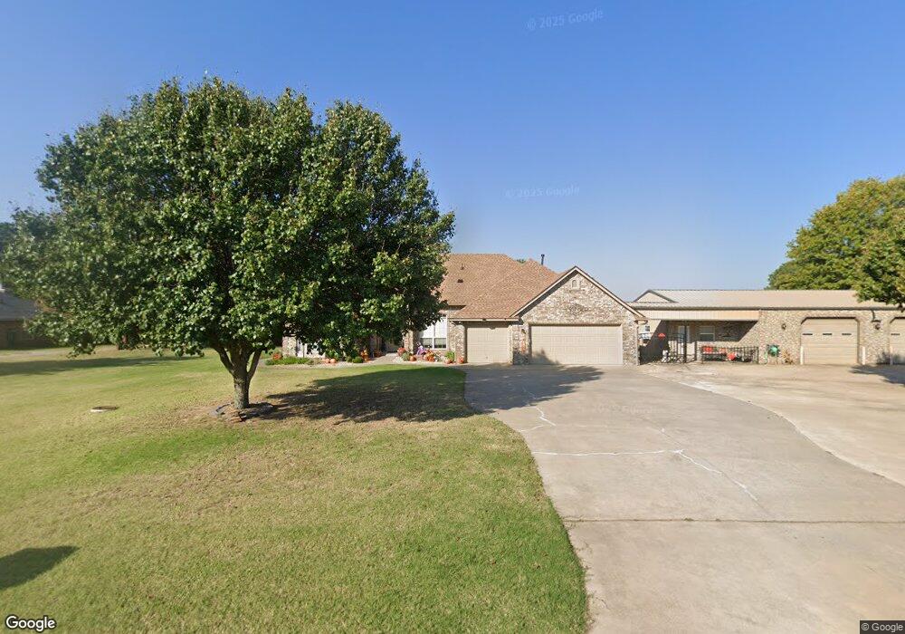
22 Melissa Shawnee, OK 74801
Estimated Value: $271,000 - $402,000
4
Beds
3
Baths
2,382
Sq Ft
$143/Sq Ft
Est. Value
About This Home
This home is located at 22 Melissa, Shawnee, OK 74801 and is currently estimated at $340,365, approximately $142 per square foot. 22 Melissa is a home located in Pottawatomie County with nearby schools including Earlsboro Elementary School and Earlsboro High School.
Ownership History
Date
Name
Owned For
Owner Type
Purchase Details
Closed on
Feb 18, 2016
Sold by
Ledford Ronnie and Ledford Euvonda
Bought by
Ledford Ronnie and Ledford Euvonda
Current Estimated Value
Home Financials for this Owner
Home Financials are based on the most recent Mortgage that was taken out on this home.
Original Mortgage
$192,000
Outstanding Balance
$152,752
Interest Rate
3.97%
Mortgage Type
New Conventional
Estimated Equity
$187,613
Purchase Details
Closed on
Jun 22, 2011
Sold by
Wilimett Leslie and Willmett Beatrice
Bought by
Ledford Euvonda and Gragg Dusti
Purchase Details
Closed on
Apr 15, 2002
Sold by
Romberg Donald and Romberg Orlena
Bought by
Willmett Leslie and Willmett Beatrie
Create a Home Valuation Report for This Property
The Home Valuation Report is an in-depth analysis detailing your home's value as well as a comparison with similar homes in the area
Home Values in the Area
Average Home Value in this Area
Purchase History
| Date | Buyer | Sale Price | Title Company |
|---|---|---|---|
| Ledford Ronnie | -- | First American Title | |
| Ledford Euvonda | -- | None Available | |
| Willmett Leslie | $10,500 | -- |
Source: Public Records
Mortgage History
| Date | Status | Borrower | Loan Amount |
|---|---|---|---|
| Open | Ledford Ronnie | $192,000 |
Source: Public Records
Tax History Compared to Growth
Tax History
| Year | Tax Paid | Tax Assessment Tax Assessment Total Assessment is a certain percentage of the fair market value that is determined by local assessors to be the total taxable value of land and additions on the property. | Land | Improvement |
|---|---|---|---|---|
| 2025 | $2,576 | $26,786 | $1,452 | $25,334 |
| 2024 | $2,533 | $26,007 | $1,410 | $24,597 |
| 2023 | $2,533 | $25,248 | $1,368 | $23,880 |
| 2022 | $2,412 | $24,513 | $1,328 | $23,185 |
| 2021 | $2,297 | $24,513 | $1,328 | $23,185 |
| 2020 | $2,234 | $23,106 | $1,251 | $21,855 |
| 2019 | $2,238 | $22,433 | $1,201 | $21,232 |
| 2018 | $2,126 | $21,780 | $1,148 | $20,632 |
| 2017 | $2,033 | $21,146 | $1,116 | $20,030 |
| 2016 | $2,095 | $20,529 | $1,085 | $19,444 |
| 2015 | $1,956 | $19,552 | $965 | $18,587 |
| 2014 | $1,862 | $18,621 | $949 | $17,672 |
Source: Public Records
Map
Nearby Homes
- 00 Allyson Ln
- 44630 Kingsbury
- 44508 Kingsbury Ln
- 00 S Rock Creek Rd
- 20302 Kings Rd
- 45201 Hardesty Rd
- 18509 Brangus Rd
- 45210 Hardesty Rd
- 44303 Hardesty Rd
- 00 Charleston Pointe
- 00 Hardesty Rd 15 Acres
- 17701 S Rock Creek Rd
- 46500 Bob Crouch Rd
- 19553 Crosslin Rd
- 0000 State Hwy 9
- 21024 Kings Rd
- 21427 S Rock Creek Rd
- 21198 Turquoise Trail
- 00 Benson Park Rd
- 18835 Ferdondo Dr