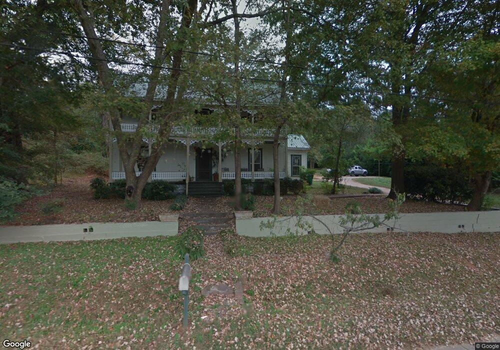
22 N Main St Maysville, GA 30558
Estimated Value: $308,000 - $386,225
4
Beds
2
Baths
2,356
Sq Ft
$152/Sq Ft
Est. Value
About This Home
This home is located at 22 N Main St, Maysville, GA 30558 and is currently estimated at $357,056, approximately $151 per square foot. 22 N Main St is a home located in Banks County with nearby schools including Banks County Primary School, Banks County Elementary School, and Banks County Middle School.
Ownership History
Date
Name
Owned For
Owner Type
Purchase Details
Closed on
May 1, 2025
Sold by
Cooley William L
Bought by
First American Bank & Trust Co Tr and Cooley Janey
Current Estimated Value
Purchase Details
Closed on
Dec 11, 2019
Sold by
First American Bank & Trust
Bought by
Foster Linda Cooley
Create a Home Valuation Report for This Property
The Home Valuation Report is an in-depth analysis detailing your home's value as well as a comparison with similar homes in the area
Home Values in the Area
Average Home Value in this Area
Purchase History
| Date | Buyer | Sale Price | Title Company |
|---|---|---|---|
| First American Bank & Trust Co Tr | -- | -- | |
| Ameriprise Bank Tr | -- | -- | |
| Cooley Mcclain Susan D | -- | -- | |
| Foster Linda Cooley | -- | -- | |
| Foster Linda Cooley | -- | -- | |
| Daniel Taylor Foster | -- | -- |
Source: Public Records
Tax History Compared to Growth
Tax History
| Year | Tax Paid | Tax Assessment Tax Assessment Total Assessment is a certain percentage of the fair market value that is determined by local assessors to be the total taxable value of land and additions on the property. | Land | Improvement |
|---|---|---|---|---|
| 2025 | $2,735 | $139,328 | $14,720 | $124,608 |
| 2024 | $2,735 | $133,886 | $13,847 | $120,039 |
| 2023 | $2,142 | $102,044 | $14,116 | $87,928 |
| 2022 | $1,731 | $79,468 | $13,148 | $66,320 |
| 2021 | $1,010 | $43,460 | $7,712 | $35,748 |
| 2020 | $1,039 | $43,460 | $7,712 | $35,748 |
| 2019 | $1,044 | $43,460 | $7,712 | $35,748 |
| 2018 | $1,049 | $43,016 | $7,712 | $35,304 |
| 2017 | $1,071 | $43,071 | $7,712 | $35,359 |
| 2016 | $1,105 | $43,071 | $7,712 | $35,359 |
| 2015 | $1,132 | $47,987 | $12,628 | $35,359 |
| 2014 | $1,132 | $47,987 | $12,628 | $35,359 |
| 2013 | -- | $47,987 | $12,628 | $35,359 |
Source: Public Records
Map
Nearby Homes
- 127 Brevard St
- 82 Maywood Ct
- 362 Sims St
- 129 Crane St
- 108 Lillie Ln
- 241 Sims St
- 382 Freeman Dr
- 393 W Freeman St
- 500 W Freeman St
- 75 Meadow Lark Way
- 199 Deadwyler Rd
- Plan 2604 at Eagle Heights
- Plan 2505 at Eagle Heights
- Plan 2906 at Eagle Heights
- Plan 1709 at Eagle Heights
- Plan 1826 at Eagle Heights
- Plan 2628 at Eagle Heights
- Plan 2239 at Eagle Heights
- Plan 1902 at Eagle Heights
- Plan 2307 at Eagle Heights