C
Seller's Agent in 2018
Carmen Price
United Real Estate
(407) 622-2122
11 Total Sales

Estimated Value: $1,183,000 - $1,540,000
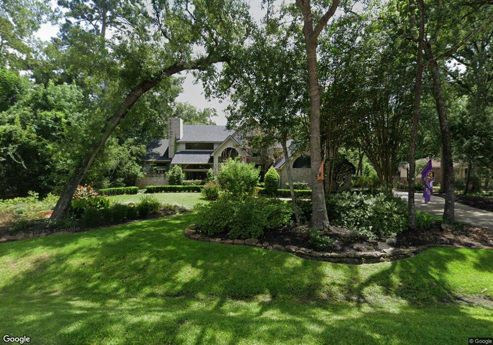
FABULOUS home in the prestigious Grogan's Point Subdivision. This resort-like home sits on almost an acre, green belt, private-wooded lot. Master bedroom down w/master bathroom that will take your breath away. Huge study/formal dining room w/windows galore. Chef's dream kitchen w/New Viking appliances. This gorgous home has been updated/remodeled in 2015-2016. Here are just a few as there are too many to name:all cabinet facings & hardware replaced in entire home, new kitchen upper/lower cabinets w/glass doors and lighting, new backsplash, new chandeliers: entryway, study and dining room, all bathrooms/laundry room remodeled ...and more. Wait until you see the gorgeous pool/spa, new outdoor kitchen w/mosquito system, outdoor security camera, whole-house gengerator and the AMAZING epoxy floor-covered 3 car garage with built-in cabinets/work bench/TV. Too much to list. Request list of updates/Improvements. You won't be disappointed. OPEN HOUSE CANCELLED FOR 2/18/18
Last Agent to Sell the Property
United Real Estate License #0650316 Listed on: 01/18/2018

| Date | Buyer | Sale Price | Title Company |
|---|---|---|---|
| Dawson Brian K | -- | Texas American Title Co | |
| Adams Thomas D | -- | Stewart Title Of Montgomery | |
| Adams Thomas D | -- | -- | |
| Adams Thomas D | -- | -- |
| Date | Status | Borrower | Loan Amount |
|---|---|---|---|
| Previous Owner | Dawson Brian K | $705,000 | |
| Previous Owner | Adams Thomas D | $417,000 |
| Date | Event | Price | List to Sale | Price per Sq Ft |
|---|---|---|---|---|
| 12/30/2021 12/30/21 | Off Market | -- | -- | -- |
| 03/27/2018 03/27/18 | Sold | -- | -- | -- |
| 02/25/2018 02/25/18 | Pending | -- | -- | -- |
| 01/18/2018 01/18/18 | For Sale | $875,000 | -- | $170 / Sq Ft |
| Year | Tax Paid | Tax Assessment Tax Assessment Total Assessment is a certain percentage of the fair market value that is determined by local assessors to be the total taxable value of land and additions on the property. | Land | Improvement |
|---|---|---|---|---|
| 2025 | $12,500 | $868,816 | -- | -- |
| 2024 | $11,336 | $789,833 | -- | -- |
| 2023 | $11,336 | $718,030 | $120,000 | $803,250 |
| 2022 | $13,191 | $652,750 | $120,000 | $719,960 |
| 2021 | $12,946 | $593,410 | $50,110 | $543,300 |
| 2020 | $14,483 | $635,800 | $50,110 | $585,690 |
| 2019 | $16,890 | $717,450 | $50,110 | $667,340 |
| 2018 | $20,545 | $872,690 | $50,110 | $822,580 |
| 2017 | $21,332 | $895,000 | $50,110 | $844,890 |
| 2016 | $23,410 | $982,170 | $50,110 | $1,017,060 |
| 2015 | $19,421 | $892,880 | $50,110 | $1,177,390 |
| 2014 | $19,421 | $811,710 | $50,110 | $761,600 |
C
Seller's Agent in 2018
Carmen Price
United Real Estate
(407) 622-2122
11 Total Sales
Source: Houston Association of REALTORS®
MLS Number: 3430046
APN: 9728-59-02500
Disclaimer: Certain information contained herein is derived from information provided by parties other than Homes.com. All information provided is deemed reliable, but is not guaranteed to be accurate and should be independently verified.
![]() Copyright 2026, Houston REALTORS® Information Service, Inc.
Copyright 2026, Houston REALTORS® Information Service, Inc.
The information provided is exclusively for consumers’ personal, non-commercial use, and may not be used for any purpose other than to identify prospective properties consumers may be interested in purchasing.
Information is deemed reliable but not guaranteed.
Ask me questions while you tour the home.