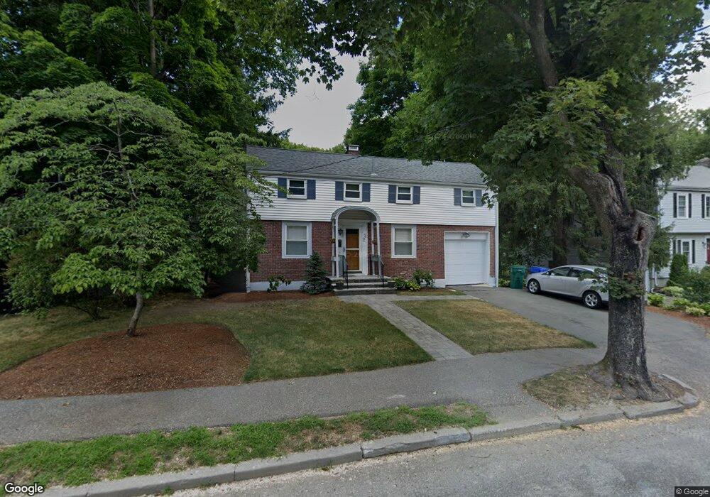
22 Roosevelt Rd Newton Center, MA 02459
Thompsonville NeighborhoodEstimated Value: $1,248,000 - $1,479,912
3
Beds
2
Baths
1,768
Sq Ft
$778/Sq Ft
Est. Value
About This Home
This home is located at 22 Roosevelt Rd, Newton Center, MA 02459 and is currently estimated at $1,375,728, approximately $778 per square foot. 22 Roosevelt Rd is a home located in Middlesex County with nearby schools including Countryside Elementary School, Bowen School, and Charles E Brown Middle School.
Ownership History
Date
Name
Owned For
Owner Type
Purchase Details
Closed on
May 30, 1997
Sold by
Gai Eliezer and Gai Margalit
Bought by
Gai Eliezer
Current Estimated Value
Home Financials for this Owner
Home Financials are based on the most recent Mortgage that was taken out on this home.
Original Mortgage
$80,000
Interest Rate
8.09%
Mortgage Type
Purchase Money Mortgage
Create a Home Valuation Report for This Property
The Home Valuation Report is an in-depth analysis detailing your home's value as well as a comparison with similar homes in the area
Home Values in the Area
Average Home Value in this Area
Purchase History
| Date | Buyer | Sale Price | Title Company |
|---|---|---|---|
| Gai Eliezer | $157,500 | -- |
Source: Public Records
Mortgage History
| Date | Status | Borrower | Loan Amount |
|---|---|---|---|
| Open | Gai Eliezer | $75,785 | |
| Closed | Gai Eliezer | $80,000 |
Source: Public Records
Tax History Compared to Growth
Tax History
| Year | Tax Paid | Tax Assessment Tax Assessment Total Assessment is a certain percentage of the fair market value that is determined by local assessors to be the total taxable value of land and additions on the property. | Land | Improvement |
|---|---|---|---|---|
| 2025 | $10,628 | $1,084,500 | $1,019,700 | $64,800 |
| 2024 | $10,276 | $1,052,900 | $990,000 | $62,900 |
| 2023 | $9,634 | $946,400 | $769,300 | $177,100 |
| 2022 | $9,219 | $876,300 | $712,300 | $164,000 |
| 2021 | $8,895 | $826,700 | $672,000 | $154,700 |
| 2020 | $8,631 | $826,700 | $672,000 | $154,700 |
| 2019 | $8,387 | $802,600 | $652,400 | $150,200 |
| 2018 | $7,927 | $732,600 | $587,100 | $145,500 |
| 2017 | $7,685 | $691,100 | $553,900 | $137,200 |
| 2016 | $7,350 | $645,900 | $517,700 | $128,200 |
| 2015 | $7,008 | $603,600 | $483,800 | $119,800 |
Source: Public Records
Map
Nearby Homes
- 28 Roosevelt Rd
- 16 Roosevelt Rd
- 16 Roosevelt Rd Unit 4
- 12 Roosevelt Rd
- 27 Theodore Rd
- 380 Parker St
- 33 Theodore Rd
- 34 Roosevelt Rd
- 384 Parker St Unit 386
- 386 Parker St Unit 386
- 384 Parker St Unit 384
- 388-390 Parker St
- 388 Parker St Unit 390
- 372 Parker St
- 19 Roosevelt Rd
- 25 Roosevelt Rd
- 39 Theodore Rd
- 15 Roosevelt Rd
- 40 Roosevelt Rd
- 31 Roosevelt Rd