
Seller's Agent in 2025
John McFadden
RE/MAX
(610) 455-2301
65 in this area
245 Total Sales
Estimated Value: $614,000 - $687,000
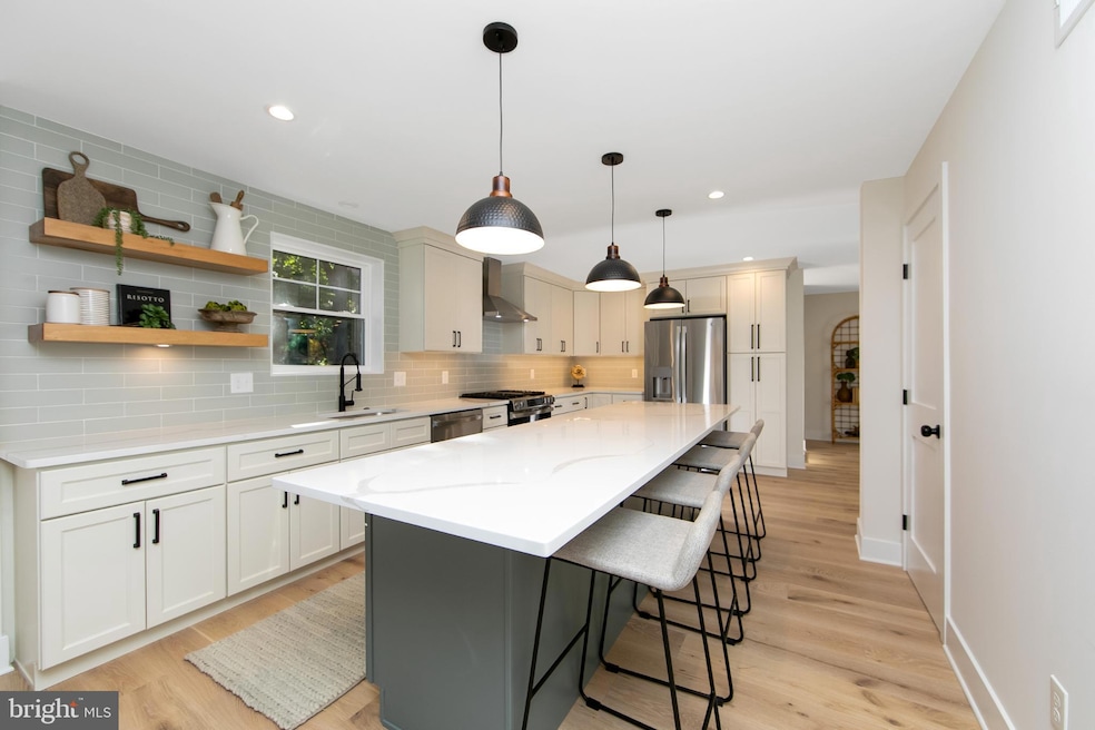
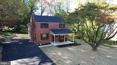
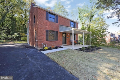
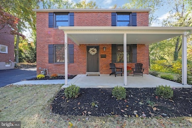
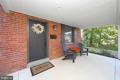
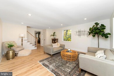
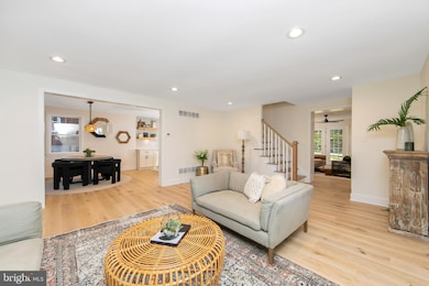
Homes like this are in high demand in the Springfield School District, and this stunning 4-bedroom brick colonial in the sought-after Scenic Hills section is truly a must-see. Perfectly situated on a picturesque lot backing to Walsh Park and a peaceful stream, this home offers a rare combination of privacy, scenery, and modern living. Taken down to the brick and completely rebuilt, it’s essentially new construction—everything from the studs to the insulation, wiring, plumbing, roof, siding, and HVAC are brand new. The already existing expansion foundation has also been finished, providing even more living space than the original footprint. Step onto the charming covered front porch and enter an impressively remodeled interior. The spacious living room welcomes you with new engineered white oak flooring that flows seamlessly throughout the main level. To your left, the dining area opens to a showstopping kitchen featuring a massive 10-foot island with breakfast bar, abundant cabinet and counter space, under cabinet lighting, and a gas stainless steel range with hood. The back side of the kitchen opens to a bright and inviting family room, where French doors lead to a rear patio overlooking the serene park and stream. Completing the main level are a convenient half bath and mud area tucked off the side entrance connect to the driveway that is brand new and side-by-side shared. Upstairs, the primary suite feels like a private retreat with a walk-in closet and a luxurious en-suite bath offering a double vanity and tile shower. Down the hall are three additional bedrooms, a hall bath, and the always-popular second-floor laundry room. The basement spans nearly 1,000 square feet between the original and expansion foundations, ready to be finished for even more living space, complete with walk-up access to the backyard. With the Septa trolley just down the block, Scenic Hills Elementary a stone's throw away, downtown Springfield approximately a mile away, and unbeatable access to Route 1, I-476, King of Prussia, the airport, Center City, Philly's Stadium District, and even tax-free Delaware, this home delivers exceptional style, comfort, and convenience in one of Delaware County’s most desirable ccommunities. Across the street are a large SEPTA lot to the left and Madison Rd to the right, both allowing for lots of guest parking.
Last Agent to Sell the Property
(610) 566-1340 johnmcfadden@remax.net RE/MAX Hometown Realtors License #RM420338 Listed on: 10/22/2025
Last Buyer's Agent
(610) 565-1995 klrw709@kw.com Keller Williams Real Estate - Media License #RS353970
| Date | Buyer | Sale Price | Title Company |
|---|---|---|---|
| Oakley Daniel | $685,000 | Keystone Premier Settlement Se | |
| Juliano Properties Llc | $225,000 | None Listed On Document | |
| Juliano Properties Llc | $225,000 | None Listed On Document | |
| Scarani Peter J | -- | -- |
| Date | Status | Borrower | Loan Amount |
|---|---|---|---|
| Open | Oakley Daniel | $650,750 | |
| Previous Owner | Juliano Properties Llc | $418,750 | |
| Previous Owner | Scarani Peter J | $128,000 |
| Date | Event | Price | List to Sale | Price per Sq Ft |
|---|---|---|---|---|
| 11/24/2025 11/24/25 | Sold | $685,000 | +0.8% | $262 / Sq Ft |
| 10/27/2025 10/27/25 | Pending | -- | -- | -- |
| 10/22/2025 10/22/25 | For Sale | $679,900 | -- | $260 / Sq Ft |
| Year | Tax Paid | Tax Assessment Tax Assessment Total Assessment is a certain percentage of the fair market value that is determined by local assessors to be the total taxable value of land and additions on the property. | Land | Improvement |
|---|---|---|---|---|
| 2025 | $7,690 | $273,610 | $100,170 | $173,440 |
| 2024 | $7,690 | $273,610 | $100,170 | $173,440 |
| 2023 | $7,405 | $273,610 | $100,170 | $173,440 |
| 2022 | $7,245 | $273,610 | $100,170 | $173,440 |
| 2021 | $11,220 | $273,610 | $100,170 | $173,440 |
| 2020 | $5,819 | $128,420 | $48,160 | $80,260 |
| 2019 | $5,683 | $128,420 | $48,160 | $80,260 |
| 2018 | $5,601 | $128,420 | $0 | $0 |
| 2017 | $5,472 | $128,420 | $0 | $0 |
| 2016 | $705 | $128,420 | $0 | $0 |
| 2015 | $719 | $128,420 | $0 | $0 |
| 2014 | $705 | $128,420 | $0 | $0 |
Seller's Agent in 2025
John McFadden
RE/MAX
(610) 455-2301
65 in this area
245 Total Sales
Seller Co-Listing Agent in 2025
Vincent Prestileo
RE/MAX
(610) 455-2313
47 in this area
147 Total Sales
Buyer's Agent in 2025
Susan Oakley
Keller Williams Real Estate - Media
(610) 209-6682
12 in this area
35 Total Sales
Source: Bright MLS
MLS Number: PADE2102644
APN: 42-00-05738-00
Disclaimer: Certain information contained herein is derived from information provided by parties other than Homes.com. All information provided is deemed reliable, but is not guaranteed to be accurate and should be independently verified.
![]() The data relating to real estate for sale on this website appears in part through the BRIGHT Internet Data Exchange program, a voluntary cooperative exchange of property listing data between licensed real estate brokerage firms, and is provided by BRIGHT through a licensing agreement.
The data relating to real estate for sale on this website appears in part through the BRIGHT Internet Data Exchange program, a voluntary cooperative exchange of property listing data between licensed real estate brokerage firms, and is provided by BRIGHT through a licensing agreement.
Listing information is from various brokers who participate in the Bright MLS IDX program and not all listings may be visible on the site.
The property information being provided on or through the website is for the personal, non-commercial use of consumers and such information may not be used for any purpose other than to identify prospective properties consumers may be interested in purchasing.
Some properties which appear for sale on the website may no longer be available because they are for instance, under contract, sold or are no longer being offered for sale.
Property information displayed is deemed reliable but is not guaranteed.
Copyright 2026 Bright MLS, Inc.
Ask me questions while you tour the home.