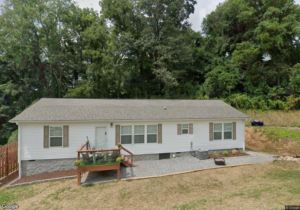
22 Sharptown Rd Canton, NC 28716
Estimated Value: $273,000 - $426,000
3
Beds
2
Baths
1,560
Sq Ft
$235/Sq Ft
Est. Value
About This Home
This home is located at 22 Sharptown Rd, Canton, NC 28716 and is currently estimated at $367,193, approximately $235 per square foot. 22 Sharptown Rd is a home located in Haywood County with nearby schools including North Canton Elementary School, Canton Middle, and Pisgah High School.
Ownership History
Date
Name
Owned For
Owner Type
Purchase Details
Closed on
Oct 28, 2022
Sold by
Whitaker Katherine Thomason
Bought by
Sanford Kenneth Brett and Milner Jennifer
Current Estimated Value
Create a Home Valuation Report for This Property
The Home Valuation Report is an in-depth analysis detailing your home's value as well as a comparison with similar homes in the area
Home Values in the Area
Average Home Value in this Area
Purchase History
| Date | Buyer | Sale Price | Title Company |
|---|---|---|---|
| Sanford Kenneth Brett | $1,000 | Chicago Title | |
| Sanford Kenneth Brett | $1,000 | Chicago Title |
Source: Public Records
Tax History
| Year | Tax Paid | Tax Assessment Tax Assessment Total Assessment is a certain percentage of the fair market value that is determined by local assessors to be the total taxable value of land and additions on the property. | Land | Improvement |
|---|---|---|---|---|
| 2025 | -- | $196,800 | $9,600 | $187,200 |
| 2024 | $12 | $196,800 | $9,600 | $187,200 |
| 2023 | $436 | $50,400 | $11,400 | $39,000 |
| 2022 | $429 | $50,400 | $11,400 | $39,000 |
| 2021 | $429 | $50,400 | $11,400 | $39,000 |
| 2020 | $326 | $28,500 | $9,000 | $19,500 |
| 2019 | $331 | $28,500 | $9,000 | $19,500 |
| 2018 | $331 | $28,500 | $9,000 | $19,500 |
| 2017 | $331 | $28,500 | $0 | $0 |
| 2016 | $326 | $28,600 | $0 | $0 |
| 2015 | $326 | $28,600 | $0 | $0 |
| 2014 | $247 | $28,600 | $0 | $0 |
Source: Public Records
Map
Nearby Homes
- 223 N Main St
- 83 Flint St
- 91 Star Ridge Rd
- 99999 Allen St
- 412 Trammell Ave
- 3 Elizabeth St
- 622 N Main St
- 761 N Main St
- 318 Academy St
- 28 Plemmons St
- 118 Mitchell St
- 62 Mitchell St
- 13 Eastwood Dr
- 687 Holtzclaw Rd
- 382 Holtzclaw St
- 228 Chestnut Mountain Rd
- 239 Northside St
- 113 Hillside St
- 112 Hy Vu Dr
- 606 Oakmont Dr
- 24 Sharptown Rd
- 78 Newfound St
- 9 Sharptown Rd
- 42 Sharptown Rd
- 6 Sharptown Rd
- 76 Newfound St
- 48 Sharptown Rd
- 2 Sharptown Rd
- 86 Newfound St
- 20 Sharptown Rd
- 53 Sharptown Rd
- 41 Sharptown Rd
- 70 Newfound St
- 81 Newfound St
- 77 Newfound St
- 83 Newfound St
- 409 Newfound St
- 75 Newfound St
- 85 Newfound St
- tbd Sharptown Rd
Your Personal Tour Guide
Ask me questions while you tour the home.