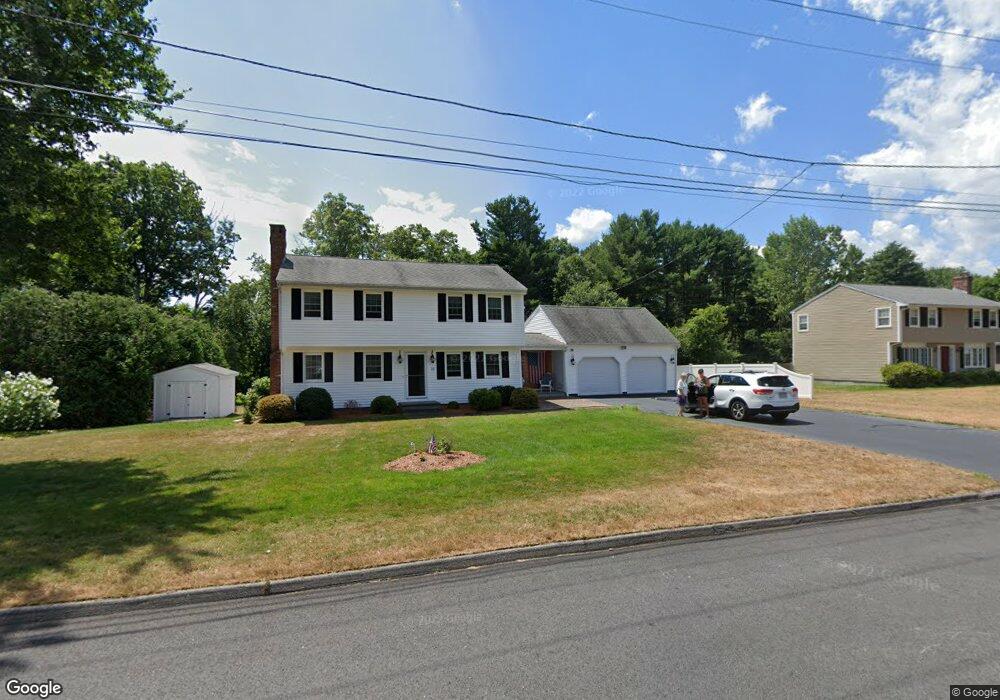
22 Trinity Ave Grafton, MA 01519
Estimated Value: $538,000 - $697,000
4
Beds
2
Baths
1,820
Sq Ft
$349/Sq Ft
Est. Value
About This Home
This home is located at 22 Trinity Ave, Grafton, MA 01519 and is currently estimated at $634,734, approximately $348 per square foot. 22 Trinity Ave is a home located in Worcester County with nearby schools including Grafton High School and Silver Spruce Montessori School.
Ownership History
Date
Name
Owned For
Owner Type
Purchase Details
Closed on
Jun 19, 2023
Sold by
Mooza Robert J and Mooza Jeanne M
Bought by
R J & Jeanne M Mooza Rt and Mooza
Current Estimated Value
Purchase Details
Closed on
Jun 1, 1979
Bought by
Mooza Robert J and Mooza Jeanne M
Create a Home Valuation Report for This Property
The Home Valuation Report is an in-depth analysis detailing your home's value as well as a comparison with similar homes in the area
Home Values in the Area
Average Home Value in this Area
Purchase History
| Date | Buyer | Sale Price | Title Company |
|---|---|---|---|
| R J & Jeanne M Mooza Rt | -- | None Available | |
| R J & Jeanne M Mooza Rt | -- | None Available | |
| R J & Jeanne M Mooza Rt | -- | None Available | |
| Mooza Robert J | -- | -- |
Source: Public Records
Mortgage History
| Date | Status | Borrower | Loan Amount |
|---|---|---|---|
| Previous Owner | Mooza Robert J | $200,000 | |
| Previous Owner | Mooza Robert J | $101,000 | |
| Previous Owner | Mooza Robert J | $100,000 | |
| Previous Owner | Mooza Robert J | $75,000 |
Source: Public Records
Tax History
| Year | Tax Paid | Tax Assessment Tax Assessment Total Assessment is a certain percentage of the fair market value that is determined by local assessors to be the total taxable value of land and additions on the property. | Land | Improvement |
|---|---|---|---|---|
| 2025 | $8,042 | $576,900 | $204,000 | $372,900 |
| 2024 | $7,875 | $550,300 | $194,300 | $356,000 |
| 2023 | $7,450 | $474,200 | $194,300 | $279,900 |
| 2022 | $7,130 | $422,400 | $166,600 | $255,800 |
| 2021 | $7,020 | $408,600 | $151,500 | $257,100 |
| 2020 | $6,702 | $406,200 | $151,500 | $254,700 |
| 2019 | $6,158 | $369,600 | $136,200 | $233,400 |
| 2018 | $5,670 | $341,800 | $135,500 | $206,300 |
| 2017 | $5,333 | $325,200 | $127,700 | $197,500 |
| 2016 | $4,551 | $271,700 | $105,400 | $166,300 |
| 2015 | $4,498 | $272,600 | $104,300 | $168,300 |
| 2014 | $4,276 | $280,200 | $122,100 | $158,100 |
Source: Public Records
Map
Nearby Homes
- 56 Luka Dr Unit 56
- 64 Fisherville Terrace
- 62 Fisherville Terrace
- 58 Fisherville Terrace
- 44 Fisherville Terrace
- 55 Fisherville Terrace
- 53 Fisherville Terrace
- 29 Pullard Rd
- 51 Londonderry Rd Unit 51
- 7 Pleasant St
- 70 Londonderry Rd
- 63 Providence Rd Unit 2
- 150 Ariel Cir
- 24 Cortland Way
- 6 Oak St
- 191 Hartness Rd
- 90 Leland Hill Rd
- 17 Worcester St
- 8 Autumn Gate Cir
- 12 Village Green
- 20 Trinity Ave
- 24 Trinity Ave
- 21 Trinity Ave
- 19 Trinity Ave
- 18 Trinity Ave
- 23 Trinity Ave
- 17 Trinity Ave
- 16 Trinity Ave
- 19 Powerline Dr
- 13 Trinity Ave
- 14 Trinity Ave
- 17 Powerline Dr
- 25 Trinity Ave
- 16 Powerline Dr
- 11 Trinity Ave
- 12 Trinity Ave
- 14 Powerline Dr
- 9 Trinity Ave
- 13 Powerline Dr
- 10 Trinity Ave
Your Personal Tour Guide
Ask me questions while you tour the home.