Estimated Value: $92,000 - $136,000
--
Bed
--
Bath
1,456
Sq Ft
$77/Sq Ft
Est. Value
About This Home
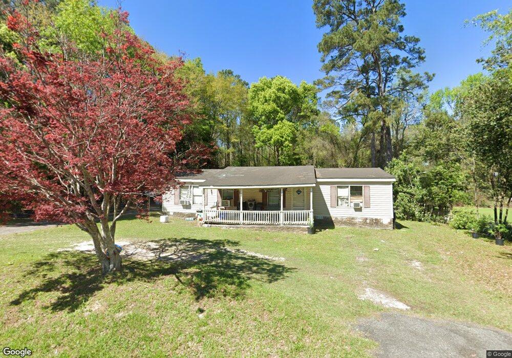
This home is located at 220 12th Ave SW, Cairo, GA 39828 and is currently estimated at $111,667, approximately $76 per square foot. 220 12th Ave SW is a home with nearby schools including Cairo High School.
Ownership History
Date
Name
Owned For
Owner Type
Purchase Details
Closed on
Dec 31, 2009
Sold by
United National Bank
Bought by
Bustamante Rachel M
Current Estimated Value
Purchase Details
Closed on
Nov 3, 2009
Sold by
United National Bank
Bought by
United National Bank
Purchase Details
Closed on
Jan 7, 2005
Sold by
Mills Robbie
Bought by
Shulenberger William and Shulenberger Gloria
Purchase Details
Closed on
Dec 21, 1994
Bought by
Ellis Debbie
Create a Home Valuation Report for This Property
The Home Valuation Report is an in-depth analysis detailing your home's value as well as a comparison with similar homes in the area
Home Values in the Area
Average Home Value in this Area
Purchase History
| Date | Buyer | Sale Price | Title Company |
|---|---|---|---|
| Bustamante Rachel M | $45,000 | -- | |
| United National Bank | -- | -- | |
| Shulenberger William | $42,500 | -- | |
| Ellis Debbie | $40,000 | -- |
Source: Public Records
Tax History Compared to Growth
Tax History
| Year | Tax Paid | Tax Assessment Tax Assessment Total Assessment is a certain percentage of the fair market value that is determined by local assessors to be the total taxable value of land and additions on the property. | Land | Improvement |
|---|---|---|---|---|
| 2024 | $252 | $6,392 | $5,200 | $1,192 |
| 2023 | $118 | $3,181 | $2,944 | $237 |
| 2022 | $122 | $3,181 | $2,944 | $237 |
| 2021 | $123 | $3,181 | $2,944 | $237 |
| 2020 | $123 | $3,181 | $2,944 | $237 |
| 2019 | $123 | $3,181 | $2,944 | $237 |
| 2016 | -- | $10,423 | $2,944 | $7,479 |
| 2015 | -- | $10,423 | $2,944 | $7,479 |
| 2014 | -- | $10,423 | $2,944 | $7,479 |
| 2013 | -- | $3,180 | $2,944 | $236 |
Source: Public Records
Map
Nearby Homes
- 109 Oriac Ave SW
- 117 Pine Cir SW
- 112 Pine Cir SW
- 1193 S Broad St
- 720 1st St SW
- 270 Muggridge Ln
- 75 14th Ave SE
- 27 6th Ave SW
- 460 2nd St SW
- 786 Madison Ln
- 40 5th Ave SW
- 000 Hwy 111 South 20 59 Acres
- 000 S Broad St
- 425 8th St SW
- 130 17th Ave SE
- 602 4th St SE
- 1310 Stone Ave
- 1406 Platt Ave
- 481 4th St SE
- 530 6th Ave SE
- 200 12th Ave SW
- 230 12th Ave SW
- 205 12th Ave SW
- 236 12th Ave SW
- 220 13th Ave SW
- 198 12th Ave SW
- 235 12th Ave SW
- 232 13th Ave SW
- 244 13th Ave SW
- 187 12th Ave SW
- 182 12th Ave SW
- 144 Pine Cir SW
- 287 12th Ave SW
- 221 13th Ave SW
- 231 13th Ave SW
- 107 Oriac Ave SW
- 173 12th Ave SW
- 241 13th Ave SW
- 162 12th Ave SW
- 129 Pine Cir SW