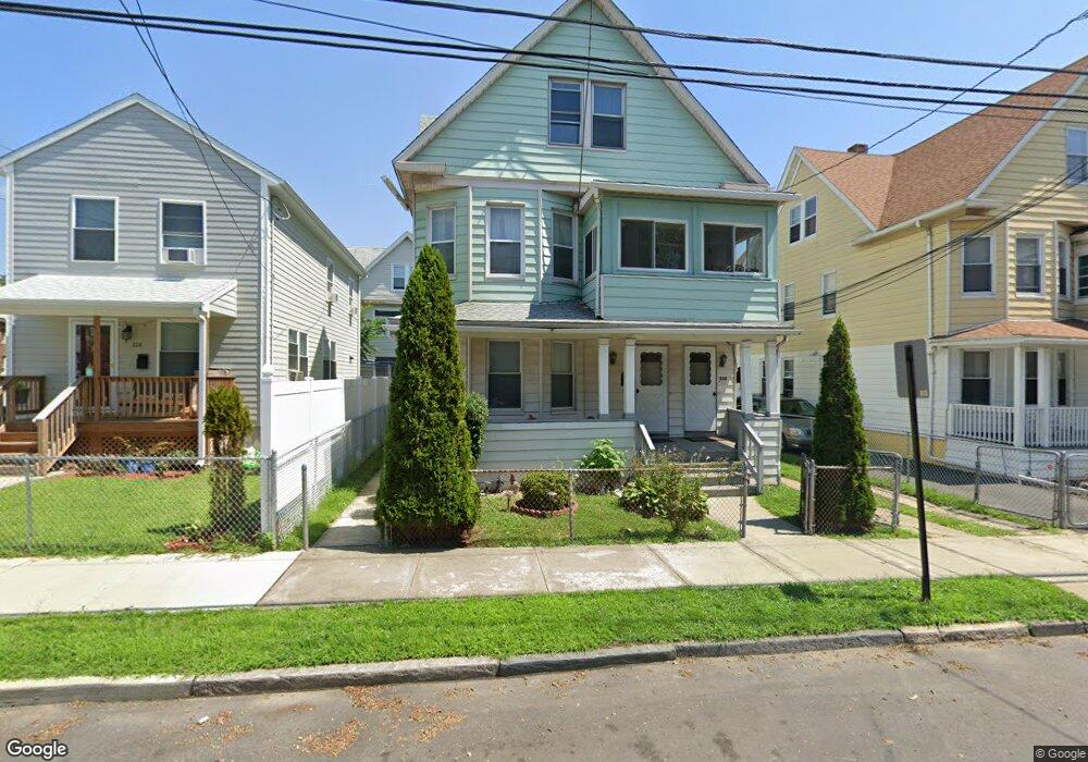
220 Davenport St Unit 222 Bridgeport, CT 06607
East End NeighborhoodEstimated Value: $334,363 - $514,000
4
Beds
2
Baths
2,966
Sq Ft
$146/Sq Ft
Est. Value
About This Home
This home is located at 220 Davenport St Unit 222, Bridgeport, CT 06607 and is currently estimated at $434,341, approximately $146 per square foot. 220 Davenport St Unit 222 is a home located in Fairfield County with nearby schools including Jettie S. Tisdale School, Harding High School, and Capital Prep Harbor Upper School.
Ownership History
Date
Name
Owned For
Owner Type
Purchase Details
Closed on
Oct 2, 1995
Sold by
Fnma
Bought by
Lovell Marva N
Current Estimated Value
Purchase Details
Closed on
Nov 21, 1990
Sold by
Mcaden Ralph
Bought by
Campbell Randal
Create a Home Valuation Report for This Property
The Home Valuation Report is an in-depth analysis detailing your home's value as well as a comparison with similar homes in the area
Home Values in the Area
Average Home Value in this Area
Purchase History
| Date | Buyer | Sale Price | Title Company |
|---|---|---|---|
| Lovell Marva N | $22,000 | -- | |
| Lovell Marva N | $22,000 | -- | |
| Campbell Randal | $114,000 | -- |
Source: Public Records
Mortgage History
| Date | Status | Borrower | Loan Amount |
|---|---|---|---|
| Open | Campbell Randal | $198,317 | |
| Closed | Campbell Randal | $195,387 |
Source: Public Records
Tax History Compared to Growth
Tax History
| Year | Tax Paid | Tax Assessment Tax Assessment Total Assessment is a certain percentage of the fair market value that is determined by local assessors to be the total taxable value of land and additions on the property. | Land | Improvement |
|---|---|---|---|---|
| 2025 | $6,353 | $146,210 | $28,290 | $117,920 |
| 2024 | $6,353 | $146,210 | $28,290 | $117,920 |
| 2023 | $6,353 | $146,210 | $28,290 | $117,920 |
| 2022 | $6,353 | $146,210 | $28,290 | $117,920 |
| 2021 | $6,353 | $146,210 | $28,290 | $117,920 |
| 2020 | $6,066 | $112,360 | $15,830 | $96,530 |
| 2019 | $6,066 | $112,360 | $15,830 | $96,530 |
| 2018 | $6,109 | $112,360 | $15,830 | $96,530 |
| 2017 | $6,109 | $112,360 | $15,830 | $96,530 |
| 2016 | $6,109 | $112,360 | $15,830 | $96,530 |
| 2015 | $6,747 | $159,890 | $27,140 | $132,750 |
| 2014 | $6,747 | $159,890 | $27,140 | $132,750 |
Source: Public Records
Map
Nearby Homes
- 179 Read St
- 1440 Stratford Ave
- 1034 Connecticut Ave
- 68 Edwin St Unit 70
- 306 Carroll Ave
- 363 Carroll Ave Unit 365
- 408 Union Ave
- 785 Connecticut Ave Unit 2
- 580 Wilmot Ave Unit 2
- 610 Wilmot Ave Unit 4
- 591 Wilmot Ave Unit 3
- 566 Wilmot Ave Unit 4
- 819 Connecticut Ave Unit 6
- 49 Bunnell St Unit 51
- 54 6th St
- 643 Newfield Ave Unit 645
- 221 Bunnell St
- 40 5th St
- 205 Smith St
- 93 Clifford St
- 212 Davenport St Unit 214
- 228 Davenport St
- 128 Kelsey St Unit 130
- 166 Kelsey St Unit 3
- 164 Kelsey St Unit 166
- 164 Kelsey St Unit 1ST F
- 164 Kelsey St Unit 3d FL
- 164 Kelsey St Unit 2
- 202 Davenport St
- 199 Alex St
- 168 Kelsey St Unit 170
- 168 Kelsey St Unit 1
- 168 Kelsey St Unit 2
- 120 Kelsey St
- 120 Kelsey St Unit 2nd Fl.
- 248 Davenport St Unit 254
- 233 Alex St
- 255 Davenport St Unit 3
- 255 Davenport St Unit 1st
- 255 Davenport St