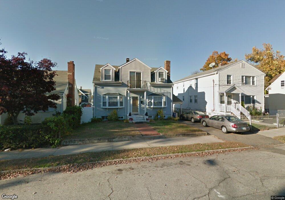
220 Hansen Ave Bridgeport, CT 06605
Black Rock NeighborhoodEstimated Value: $350,000 - $471,000
4
Beds
2
Baths
1,562
Sq Ft
$263/Sq Ft
Est. Value
About This Home
This home is located at 220 Hansen Ave, Bridgeport, CT 06605 and is currently estimated at $410,075, approximately $262 per square foot. 220 Hansen Ave is a home located in Fairfield County with nearby schools including Black Rock School, Bassick High School, and Park City Prep Charter School.
Ownership History
Date
Name
Owned For
Owner Type
Purchase Details
Closed on
Jun 8, 2001
Sold by
Rizzetta Frank and Rizzetta Anna
Bought by
Furino Derek and Furino Zunilda
Current Estimated Value
Home Financials for this Owner
Home Financials are based on the most recent Mortgage that was taken out on this home.
Original Mortgage
$138,550
Interest Rate
7.08%
Create a Home Valuation Report for This Property
The Home Valuation Report is an in-depth analysis detailing your home's value as well as a comparison with similar homes in the area
Home Values in the Area
Average Home Value in this Area
Purchase History
| Date | Buyer | Sale Price | Title Company |
|---|---|---|---|
| Furino Derek | $140,750 | -- | |
| Furino Derek | $140,750 | -- |
Source: Public Records
Mortgage History
| Date | Status | Borrower | Loan Amount |
|---|---|---|---|
| Open | Furino Derek | $315,000 | |
| Closed | Furino Derek | $210,000 | |
| Closed | Furino Derek | $138,550 |
Source: Public Records
Tax History Compared to Growth
Tax History
| Year | Tax Paid | Tax Assessment Tax Assessment Total Assessment is a certain percentage of the fair market value that is determined by local assessors to be the total taxable value of land and additions on the property. | Land | Improvement |
|---|---|---|---|---|
| 2025 | $8,532 | $196,360 | $109,070 | $87,290 |
| 2024 | $8,532 | $196,360 | $109,070 | $87,290 |
| 2023 | $8,532 | $196,360 | $109,070 | $87,290 |
| 2022 | $8,532 | $196,360 | $109,070 | $87,290 |
| 2021 | $8,532 | $196,360 | $109,070 | $87,290 |
| 2020 | $7,542 | $139,700 | $70,810 | $68,890 |
| 2019 | $7,542 | $139,700 | $70,810 | $68,890 |
| 2018 | $7,595 | $139,700 | $70,810 | $68,890 |
| 2017 | $7,595 | $139,700 | $70,810 | $68,890 |
| 2016 | $7,595 | $139,700 | $70,810 | $68,890 |
| 2015 | $6,029 | $142,860 | $59,500 | $83,360 |
| 2014 | $6,029 | $142,860 | $59,500 | $83,360 |
Source: Public Records
Map
Nearby Homes
- 82 Waldorf Ave
- 144 Whittier St
- 135 Whittier St
- 167 Scofield Ave
- 105 Scofield Ave
- 31 Whittier St
- 25 Whittier St
- 166 Alfred St
- 51 Princeton St
- 855 Brewster St Unit 857
- 118 Berwick Ave
- 130 Brentwood Ave
- 2773 Fairfield Ave Unit 3
- 37 Rowsley St Unit 6
- 145 Brentwood Ave
- 26 Rowsley St Unit 3
- 20 Haddon St Unit 5
- 222 Ellsworth St
- 554 Brewster St Unit 4
- 165 Bennett St
- 210 Hansen Ave
- 230 Hansen Ave
- 212 Hansen Ave
- 240 Hansen Ave
- 65 Davis Ave
- 67 Davis Ave
- 77 Davis Ave
- 198 Hansen Ave
- 55 Davis Ave Unit 1st
- 55 Davis Ave Unit 3
- 55 Davis Ave
- 55 Davis Ave Unit 1
- 53 Davis Ave Unit 55
- 53 Davis Ave Unit 3
- 217 Hansen Ave
- 247 Hansen Ave
- 87 Davis Ave
- 37 Davis Ave
- 248 Hansen Ave
- 227 Hansen Ave