
Seller's Agent in 2025
Erica McIlwaine
The Legacy Real Estate Group
(678) 787-8594
9 in this area
29 Total Sales
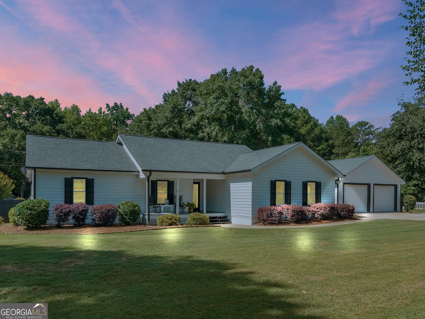
Charming Ranch with In-Law Suite & Private Backyard Oasis. Welcome to this beautifully maintained ranch-style home offering 3 spacious bedrooms, 3 full bathrooms, and a thoughtfully designed in-law suite with its own private entrance and full bath-perfect for multi-generational living or guests. Inside, you'll find a warm, inviting layout with two separate living areas designed for both everyday comfort and special gatherings. The formal living room greets you near the entrance with elegant finishes, and a cozy fireplace to welcome guests or unwind in a quieter setting. Toward the heart of the home, the family room offers a more casual retreat with plenty of space for entertaining and is perfect for movie nights, game days, or family time. The kitchen flows effortlessly between both living spaces and the dining area, creating an ideal layout for entertaining. The primary suite is a true retreat, complete with a luxuriously sized master closet and a private en-suite bath, offering ample room for wardrobe organization and storage. The primary suite has a separate deck overlooking the pool. Each bedroom provides comfort and privacy, with an additional private en-suite bath for the secondary bedroom. Don't forget about the in-law suite that includes a private full bath with it's own sitting area, a separate entrance, and separate parking -great for extended stays or independent living. Outside you will find your private backyard oasis, featuring a sparkling saltwater inground pool, lush landscaping and a generous patio area for outdoor dining and relaxation. As an added bonus, the crawl space is encapsulated to make it this home more energy efficient! This home is the perfect blend of style, comfort, and flexibility with a new roof, flooring, and fresh paint -ready to welcome you home!
Last Agent to Sell the Property
The Legacy Real Estate Group Brokerage Phone: 678-787-8594 License #234982 Listed on: 07/17/2025
| Date | Type | Sale Price | Title Company |
|---|---|---|---|
| Limited Warranty Deed | $399,900 | -- | |
| Warranty Deed | -- | -- | |
| Warranty Deed | -- | -- |
| Date | Status | Loan Amount | Loan Type |
|---|---|---|---|
| Open | $392,656 | FHA |
| Date | Event | Price | List to Sale | Price per Sq Ft |
|---|---|---|---|---|
| 09/12/2025 09/12/25 | Sold | $399,900 | 0.0% | $152 / Sq Ft |
| 07/19/2025 07/19/25 | Pending | -- | -- | -- |
| 07/17/2025 07/17/25 | For Sale | $399,900 | -- | $152 / Sq Ft |
| Year | Tax Paid | Tax Assessment Tax Assessment Total Assessment is a certain percentage of the fair market value that is determined by local assessors to be the total taxable value of land and additions on the property. | Land | Improvement |
|---|---|---|---|---|
| 2025 | $4,423 | $156,368 | $16,000 | $140,368 |
| 2024 | $4,423 | $150,680 | $14,720 | $135,960 |
| 2023 | $3,762 | $142,120 | $14,160 | $127,960 |
| 2022 | $3,689 | $117,520 | $13,080 | $104,440 |
| 2021 | $3,370 | $103,920 | $11,240 | $92,680 |
| 2020 | $3,142 | $94,160 | $10,560 | $83,600 |
| 2019 | $2,967 | $86,680 | $10,040 | $76,640 |
| 2018 | $2,817 | $80,200 | $9,280 | $70,920 |
| 2016 | $2,888 | $74,240 | $7,240 | $67,000 |
| 2015 | $2,807 | $69,960 | $7,800 | $62,160 |
| 2014 | -- | $58,240 | $7,800 | $50,440 |
Seller's Agent in 2025
Erica McIlwaine
The Legacy Real Estate Group
(678) 787-8594
9 in this area
29 Total Sales
S
Buyer's Agent in 2025
Stephanie Delay
Maximum One Realtor Partners
(770) 653-1558
13 in this area
42 Total Sales
Source: Georgia MLS
MLS Number: 10564042
APN: 0142-01-028-054
Disclaimer: Certain information contained herein is derived from information provided by parties other than Homes.com. All information provided is deemed reliable, but is not guaranteed to be accurate and should be independently verified.
![]() The data relating to real estate for sale on this web site comes in part from the Broker Reciprocity Program of Georgia MLS. Real estate listings held by brokerage firms other than Redfin are marked with the Broker Reciprocity logo and detailed information about them includes the name of the listing brokers. Information deemed reliable but not guaranteed. Copyright 2025 Georgia MLS. All rights reserved.
The data relating to real estate for sale on this web site comes in part from the Broker Reciprocity Program of Georgia MLS. Real estate listings held by brokerage firms other than Redfin are marked with the Broker Reciprocity logo and detailed information about them includes the name of the listing brokers. Information deemed reliable but not guaranteed. Copyright 2025 Georgia MLS. All rights reserved.