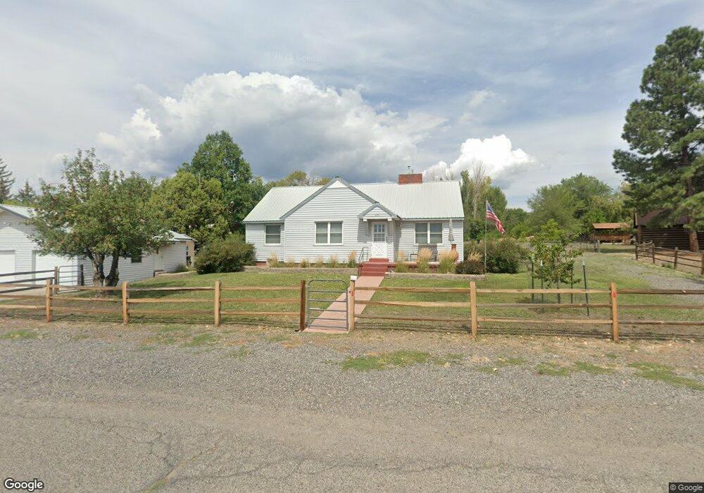
220 NW Aspen Cedaredge, CO 81413
Estimated Value: $438,515 - $526,000
3
Beds
1
Bath
1,979
Sq Ft
$248/Sq Ft
Est. Value
About This Home
This home is located at 220 NW Aspen, Cedaredge, CO 81413 and is currently estimated at $490,129, approximately $247 per square foot. 220 NW Aspen is a home located in Delta County with nearby schools including Cedaredge Elementary School, Cedaredge Middle School, and Cedaredge High School.
Ownership History
Date
Name
Owned For
Owner Type
Purchase Details
Closed on
Jul 15, 2019
Sold by
Mason Chad Ronald and Mason Britnet Lynn
Bought by
Mcgirr Jennifer J and Mcgirr Kevin P
Current Estimated Value
Home Financials for this Owner
Home Financials are based on the most recent Mortgage that was taken out on this home.
Original Mortgage
$217,600
Outstanding Balance
$190,950
Interest Rate
3.9%
Mortgage Type
New Conventional
Estimated Equity
$299,179
Purchase Details
Closed on
Sep 15, 2014
Sold by
Hampton Delmar R and Hampton Norma J
Bought by
Mason Chad Ronald and Mason Britney Lynn
Home Financials for this Owner
Home Financials are based on the most recent Mortgage that was taken out on this home.
Original Mortgage
$156,000
Interest Rate
4.15%
Mortgage Type
New Conventional
Create a Home Valuation Report for This Property
The Home Valuation Report is an in-depth analysis detailing your home's value as well as a comparison with similar homes in the area
Home Values in the Area
Average Home Value in this Area
Purchase History
| Date | Buyer | Sale Price | Title Company |
|---|---|---|---|
| Mcgirr Jennifer J | $272,000 | Heritage Title Co | |
| Mason Chad Ronald | $195,000 | Heritage Title |
Source: Public Records
Mortgage History
| Date | Status | Borrower | Loan Amount |
|---|---|---|---|
| Open | Mcgirr Jennifer J | $217,600 | |
| Previous Owner | Mason Chad Ronald | $156,000 |
Source: Public Records
Tax History Compared to Growth
Tax History
| Year | Tax Paid | Tax Assessment Tax Assessment Total Assessment is a certain percentage of the fair market value that is determined by local assessors to be the total taxable value of land and additions on the property. | Land | Improvement |
|---|---|---|---|---|
| 2024 | $1,629 | $23,898 | $3,773 | $20,125 |
| 2023 | $1,629 | $23,898 | $3,773 | $20,125 |
| 2022 | $1,336 | $19,948 | $4,518 | $15,430 |
| 2021 | $1,331 | $20,522 | $4,648 | $15,874 |
| 2020 | $830 | $12,415 | $3,933 | $8,482 |
| 2019 | $829 | $12,415 | $3,933 | $8,482 |
| 2018 | $706 | $10,082 | $2,880 | $7,202 |
| 2017 | $706 | $10,092 | $2,880 | $7,212 |
| 2016 | $840 | $13,048 | $4,211 | $8,837 |
| 2014 | -- | $14,077 | $3,662 | $10,415 |
Source: Public Records
Map
Nearby Homes
- 245 NW 3rd St
- 225 NW 4th St
- 215 N Grand Mesa Dr
- 345 1/2 NW 4th St
- 190 & 170 SW 2nd Ave Unit A, B, C
- 365 NW Cedar Ave
- 490 W Main St
- 590 NW Aspen
- 470 NW Cedar Ave
- 160 SE Antelope Ave
- 395 NW 7th St
- 105 SE Buffalo Ave
- 180 NW 7th St
- 135 SE Buffalo Ave
- 285 NW 7th St
- 155 SE Buffalo Ave
- 540 SW 3rd Ave
- 565 N Grand Mesa Dr
- 633 E Main St
- 435 NE 4th St
- 190 NW 2nd St
- 195 NW 2nd St
- 280 NW Aspen
- 265 NW Aspen
- 210 N Grand Mesa Dr
- 225 NW 3rd St
- 195 NW 3rd St
- 165 NW Aspen
- 165 NW 2nd St
- 155 NW 2nd St
- 165 NW 3rd St
- 255 NW 3rd St
- 190 N Grand Mesa Dr
- 130&140 W Main St
- NW 3rd St
- 180 NW 3rd St
- 160 N Grand Mesa Dr
- 110 NW 2nd St
- 230 & 240 W Main St
- 240 N Grand Mesa Dr