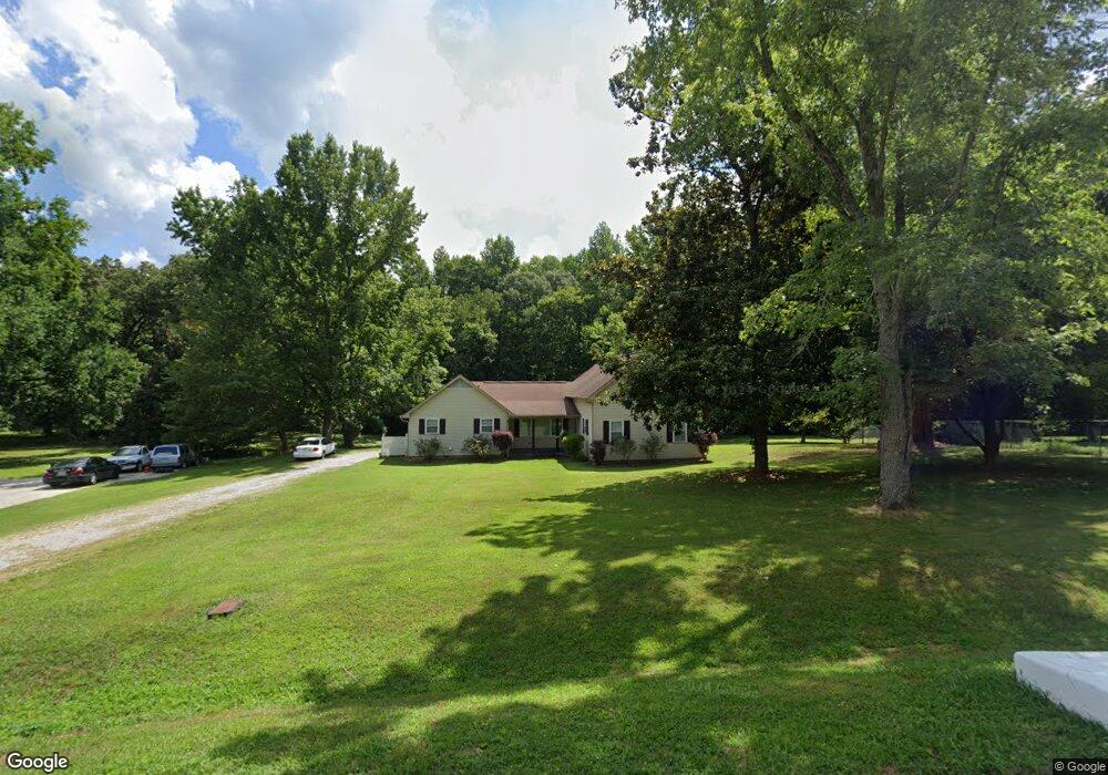
220 Powell St Gurley, AL 35748
Estimated Value: $209,000 - $276,000
3
Beds
2
Baths
1,679
Sq Ft
$144/Sq Ft
Est. Value
About This Home
This home is located at 220 Powell St, Gurley, AL 35748 and is currently estimated at $241,885, approximately $144 per square foot. 220 Powell St is a home located in Madison County with nearby schools including Central School and Madison County High School.
Ownership History
Date
Name
Owned For
Owner Type
Purchase Details
Closed on
Aug 29, 2023
Sold by
Millard Deric Shawn
Bought by
Richey Laura Lynn
Current Estimated Value
Home Financials for this Owner
Home Financials are based on the most recent Mortgage that was taken out on this home.
Original Mortgage
$169,750
Outstanding Balance
$165,783
Interest Rate
6.9%
Mortgage Type
New Conventional
Estimated Equity
$76,103
Purchase Details
Closed on
Aug 11, 2009
Sold by
Fowler George W
Bought by
Millard Larry and Millard Ruby P
Create a Home Valuation Report for This Property
The Home Valuation Report is an in-depth analysis detailing your home's value as well as a comparison with similar homes in the area
Home Values in the Area
Average Home Value in this Area
Purchase History
| Date | Buyer | Sale Price | Title Company |
|---|---|---|---|
| Richey Laura Lynn | -- | None Listed On Document | |
| Richey Laura Lynn | -- | None Listed On Document | |
| Richey Laura Lynn | -- | None Listed On Document | |
| Millard Larry | -- | -- |
Source: Public Records
Mortgage History
| Date | Status | Borrower | Loan Amount |
|---|---|---|---|
| Open | Richey Laura Lynn | $169,750 | |
| Closed | Richey Laura Lynn | $169,750 |
Source: Public Records
Tax History Compared to Growth
Tax History
| Year | Tax Paid | Tax Assessment Tax Assessment Total Assessment is a certain percentage of the fair market value that is determined by local assessors to be the total taxable value of land and additions on the property. | Land | Improvement |
|---|---|---|---|---|
| 2024 | $577 | $16,960 | $3,500 | $13,460 |
| 2023 | $561 | $33,900 | $7,000 | $26,900 |
| 2022 | $1,033 | $28,720 | $5,000 | $23,720 |
| 2021 | $931 | $25,920 | $5,000 | $20,920 |
| 2020 | $854 | $23,820 | $5,000 | $18,820 |
| 2019 | $830 | $23,140 | $5,000 | $18,140 |
| 2018 | $790 | $22,060 | $0 | $0 |
| 2017 | $772 | $21,560 | $0 | $0 |
| 2016 | $772 | $21,560 | $0 | $0 |
| 2015 | $772 | $21,560 | $0 | $0 |
| 2014 | $765 | $21,380 | $0 | $0 |
Source: Public Records
Map
Nearby Homes
- 218 Powell St
- 211 Powell St
- 102 Peyton Cir
- 107 Nolan Dr
- 221 Grasslands Rd
- 216 Grasslands Rd
- 235 Grasslands Rd
- 309 Gilliam Rd
- 1519 Ryland Pike
- 0 Gilliam Rd
- 172 Day Dr
- 3608 Maysville Rd NE
- 111 Cool Cir
- 483 Moontown Rd
- 477 Moontown Rd
- 506 Moontown Rd
- 362 Moontown Rd
- 350 Moontown Rd
- 123 Delta Pine Dr
- PPin#507136 Moontown Rd
- 7001 Huddersfield Ln SE
- 7017 Huddersfield Ln SE
- 222 Powell St
- 215 Powell St
- 216 Powell St
- 221 Powell St
- 214 Powell St
- 213 Powell St
- 212 Powell St
- 103 Peyton Cir
- 223 Powell St
- 105 Peyton Cir
- 227 Powell St
- 209 Powell St
- 228 Powell St
- 210 Powell St
- 229 Powell St
- 208 Powell St
- 230 Powell St
- 106 Strong Ln